|
|
Home--Indroducing GetRealtime automated retrieval and computations of
free real-time hydrological and meteorological
data available on the web.
About--Description and uses of the GetRealtime programs
for data acquisition and computation, visual display, and data management in
real-time.
Down Loads--Links for
free downloading latest version of programs.
Register--Restister so
I can keep an eye on you... you may need ... you know... help.
Help--Help for using Getrealtime.exe, GetGraphs.exe, and GetAccess.exe...
see.
GetNexrad Help--Help for using GetNexrad.exe radar viewer and
LatLongPixel.exe radar pixel locater. Includes NASCAR Cup Series
racing schedule and radar sites for ETA of storm cells.
More Stuff--Additional software of use to hydrologists and extensions of
GetRealtime that include:
Excel GetRegression.xls
Excel ProbabilityGraphs.xls
Excel Example with GoalSeek/Tips
GetMapArea.exe
Excel GetFlowRecord.xls
GetNexrad.exe
VolumeTimer.exe
CookingTimer.exe
ChannelStorage.exe
Excel ModPuls.xls
HurricaneAlex2010Gifs.zip
HurricaneEarl2010Gifs.zip and storms etc.
Topo Maps on Google Earth quick & easy tip
LatLongMap--Full screen Google Maps used by GetMapArea.exe for finding lat
and long of points of interest.
BigMap--Full screen Google Maps used by GetMapArea.exe for determining
runoff basin boundarys.

Getting Started with Nashville Example Rainfall Runoff (Zip 9 MB)--Fully operational project example
for radar rainfall, adjustment, and runoff computations for 3 subs at Nashville,
TN with Hec HMS, RAS and EPA-SWMM projects. Unzip the download to C:\ where the
folder C:\GetNashville will be created and
read the file READ_ME.txt.. After getting this project working then you
can copy it and convert it to your basin of interest. And here is a fully
operational SNOWMELT setup
example in New York. More questions, see
next Start Here!
Getting Started with Radar Rainfall--Steps for downloading and installing
needed programs for radar rainfall and adjustment. Get started here.
See
Radar Rainfall
Ajustment, Charlotte, NC for
really how it's done. More questions, see next Start Here!
Getting
Started with
Radar Rainfall Runoff Setup Example Harvard
Gulch--A concise step by step quide to setups for using GetRealtime radar rainfall and
runoff (top half). More questions, see Help! at top.
Getting Started with Snowmelt
(Zip 9 MB)--Fully operational project example in New York
I'm using winter and summer. If the radar over shoots and leaves you
high and dry... just set the midnight snow water equivelant from heated gages or
NOAA swe and let the melt or rain on snow proceed... and shell Hec-Ras for ice
jams I guess.
Example
Simple Single Rain Gage Adjustment Evaluation (Zip 13 MB) all inclusive setup.
I did this to compare forecasts using NWS, HRRR, and Radar Nowcasts for Hurricane Florence of
Sep 2018. If all else seems overwhelming just install GetRealtime and then
forget about that install and unzip this to C:\GetProjects\ to see a much
simpler setup. Just remember a single gage adjusted POINT radar BETTER look just
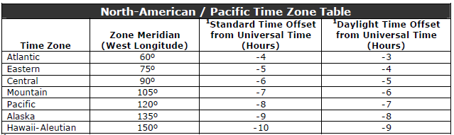
like the gaged rainfall. Also I have a -3 hr Pacific time zone shift in
NWS Forecast in GetRealtime_setup.txt and the rain gage in table 'rsite'.
---------------------------------------------------------------------
Case studies in real-time
(GetRealtime has been improved over the years as reflected in these
studies, so be sure to check out the latest results near the bottom of
each web page... actually it's the input rainfall that's been improved.)
---------------------------------------------------------------------
 Radar Rainfall
Ajustment, Charlotte, NC--Confidence building using 3 Wundergages
to adjust radar rainfall at 6 USGS rain gages and an adjusted basin runoff
comparisons. Also includes comparison of super res Level 2, Composite N0Q, and good ol' N0Q... yes, N0Q cleans their clock... I hope!
Study completed in 2013 but is still an important read. Radar Rainfall
Ajustment, Charlotte, NC--Confidence building using 3 Wundergages
to adjust radar rainfall at 6 USGS rain gages and an adjusted basin runoff
comparisons. Also includes comparison of super res Level 2, Composite N0Q, and good ol' N0Q... yes, N0Q cleans their clock... I hope!
Study completed in 2013 but is still an important read.
Radar Rainfall
3-hr NOWCAST Comparisons from around the USA--Gallery of ongoing comparisons
of
Nowcasts using Lagrangian frame of reference by moving subbasins upwind
each 5 minutes on last radar image to see how well they work... or not.
Includes NWS 7 day and HRRR 18 hour.
A Farmers Guide for the Cadillac Desert--Adjusting Water Orders on the
Colorado River Arizona-California with Gila River flooding. Includes
setups.
154 sqmi Slate Creek at Wellington, KS--Easy
automation of HEC-HMS runoff and hydrologic routings and HEC-RAS unsteady flow using GetRealtimes gage adjusted radar
rain and snowmelt for real-time continuous operation and forecasting.
Includes setups.
11.8 sqmi Browns Creek nr Nashville, TN
--3 small urban subbasins with frequent rainfall I use for testing a lot. Includes a quick look at the
frequencies of the epic May 2010 radar. Currently NOAA Madis rain gages
checked and HMS runoff routing and
is a currently updated daily to provide eyes on HMS version compatibility since
Kansas Slate Cr discontinued.
----------------------------------------------------------------
Past real-time examples of NEXRAD rainfall and runoff studies.
----------------------------------------------------------------
NWS Snowcasts of Melt and SWE Comparisons to GetRealtime from around the USA--Gallery
of ongoing comparisons of the NWS forecasts of SWE and Melt to GetRealtime
snowmelt computations (and has already let to improvements in GRT).
Runoff Comparison
Big Creek in San Joaquin Valley, CA - Updates --Comparisons of Nexrad radar generated area
averaged rainfall and snowmelt runoff with a USGS stream gage in San Joaquin
Valley, CA. Study Part 1 ended 5/18/2011. Part 2 added snowpack/melt but ended
with a Snafu and a Fubar. Part 3 winter 2013 redeems Snafu and Fubar using hourly
adjusted radar and continuous SCS loss methods. Study continues and
includes the NWS 7-day hourly weather forecast and 3-hour Nowcassts for computation of projected
rain/melt and runoff.
54 sqmi Rapid
Creek above Canyon Lake Dam, SD--5 subbasins combine with
scheduled realease from upstream Pactola Dam.
23.9 sqmi Willow Creek
nr Crooks, SD--Another high plains GetRealtimes gage adjusted radar
rain and snowmelt for real-time continuous operation and forecasting. These
basins on the high plains have extrememly long peak rain to peak runoff times,
20 hours for a 23 sqmi basin. Maybe its groundwater lag with all the
sand or something???
63.2 sqmi
Massies Creek
nr Wilmington, OH--Another close to radar GetRealtimes gage
adjusted radar rain and snowmelt for real-time continuous operation and
forecasting in Ohio. Single subbasin with GetRealtime snowmelt method.
11.8 sqmi Browns Creek nr Nashville, TN
--3 small urban subbasins with frequent rainfall. Includes a quick look at the
frequencies of the epic May 2010 radar. I've added HMS runoff routing and
is a currently updated daily to provide eyes on HMS version compatibility.
Flood control reservoirs at Houston, TX--Reservoir storage
release ratings were constructed for 2 flood control reservoirs on Buffalo Bayou
above Houtson actively operated using Hurricane Harvey 30", 2000 year(?) rainfall with current flood
relase forecasts.
168 sqmi Bear Creek
below Ashland, OR-- Nexrad 5-Minute Radar Rainfall/Snowmelt-Runoff Comparisons in Real-Time With Radar1-HR Ratio Adjustments
and Contiuous SCS Curve Number Soil Flood Potential. Updated routings for
automated scheduling of dam releases and canal diversions for
active operations for an irrigation district.
40 sqmi
Mill Creek at Dalton, GA-- Nexrad 5-Minute Radar Rainfall-Runoff Comparisons in Real-Time With Radar1-HR Ratio Adjustments
and Contiuous SCS Curve Number Soil Flood Potential. Shows reservoir
operations for 2 reservoirs not actively operated.
114 sqmi
Oneida Creek at Oneida, NY-- Snowwpack &
Melt/Rainfall Runoff Comparisons in Real-Time. Study started again Oct 1,
2017 using A2M multi-radar multi-sensor 2-minute rain rates for
winter snowfall to see if no adjustment and less overshoot can be found. Like
all other NWS precip products, A2M was once again found to be a complete dud
here.
114 sqmi
Oneida Creek at Oneida, NY-- Nexrad 5-Minute Radar Snowpack &
Melt/Rainfall Runoff Comparisons in Real-Time With Radar1-HR Ratio Adjustments
and Contiuous SCS Curve Number. Study ended with Nexrad Product dual pol.
Total Rainfall PTA a complete dud. Also the NWS runoff forecast had
forecast zero rise in stage while GetRealtime was showing Major flood stage
because of Nowcasts and just plain way better rainfall than NWS - PTA.
Large 610 sqmi Burro Creek
Basin nr Bagdad, AZ was subdivided to see if runoff computations
could be improved for this dry desert basin with some winter snowpack using N0Q
and NCQ. Because of bad results due to distance from radar sites and few
rain gages, radar product PTA storm total was tried without success so now
multi-radar multi-sensor product A2M unadjusted rainfall rate
wasevaluted and FAILED.
80 sqmi
Napa River above St Helena, CA-- Nexrad 5-Minute Radar Rainfall-Runoff Comparisons in Real-Time With Radar1-HR Ratio Adjustments
and Contiuous SCS Curve Number Soil Flood Potential. Shows reservoir
operations for a reservoir not actively operated.
Runoff Comparison
in Las Vegas, NV--Comparisons of Nexrad radar generated
area averaged rainfall runoff with a USGS stream gage and tipping bucket network
in Las Vegas Valley, NV. Includes adjusted radar rainfall error
comparisons at the tipping buckets.
Web Automation
Demo--Demonstrates GetRealtime's automation in real-time web
dissemination of runoff and forecasts imagery using the large and complex
Tallapoosa River Basin at Harris Dam, AL. Let's see if we can simplify
things and tame this big beast with radar.
Runoff Computations
for Maurice River NJ--A temporary setup example for the swampy Maurice
River near Norma, NJ.
Rainfall Comparisons
Blue Ridge Mtns, NC--Comparisons of 3 simultaneous Nexrad radar sites
generated point rainfall amounts with tipping bucket rain gages and with a 90.8
sqmi catchment with snowpack, melt, and runoff.. Radar rainfall adjusted
hourly.
Snowfall
Precip/Pack/Melt Comparisons--Comparisons
of Nexrad radar generated point snow water equivilants with Sierra snow
gauges (and Fargo). With a radar over shoot discussion and computation.
Rush
River near Fargo, ND-- Snowwpack & Melt/Rainfall Runoff Comparisons
in Real-Time.
Runoff Comparisons
in Arizon--Comparisons of four Nexrad radar generated area averaged
rainfall runoff with USGS stream gages in the northwestern Arizona deserts and
canyon lands that just never did too well but may be resussitated someday.
ET and Rainfall along
the Lower Colorado River, AZ-CA--Ongoing comparison of CIMIS vs
Wunderground Evapotranspiration computations and Nexrad radar generated
point and area averaged rainfall at irrigated farm districts of the sunny
southwestern deserts (and an African example).
Rainfall Comparisons--Comparisons of Nexrad radar generated
point rainfall amounts with tipping bucket rain gages. Includes
hypothedical peak runoff comparisons for those foolishly daring to go beyond
daily rainfall totals (this aint pretty). Study ended 5/18/2011.
More Rainfall Comparisons
Ft Lauderdale, FL--Comparisons of different Nexrad radar products
generated point rainfall amounts with tipping bucket rain gages
--------VIDEOS--------------------------------------------------------
Indirect Peak Flow Videos:
Indirect Peak Flow Measuredment by Critical Depth
Indirect Peak Flow Measuredment by
Slope-Area
More GetRealTime videos on YouTube can be found at the bottom
of my list here:
https://www.youtube.com/@GetMyRealTime/videos
--------ODDS
and ENDS----------------------------------------------
Getlocal.htm for setting GetNexrad location:
Get your PC's location info
Google Earth EPA WATERS KMZ streams and catchment boundaries as
of Sep 15, 2020:
https://www.epa.gov/waterdata/viewing-waters-data-using-google-earth
Google Earth USGS Topo Quads KMZ as of Sep 15, 2020:
http://www.earthsurvey.us/quads/quads.html
|
Year |
DST Begins 2 a.m. (Second Sunday in March) |
DST Ends 2 a.m. (First Sunday in November) |
|
2007 |
11 March 2007 |
4 November 2007 |
|
2008 |
9 March 2008 |
2 November 2008 |
|
2009 |
8 March 2009 |
1 November 2009 |
|
2010 |
14 March 2010 |
7 November 2010 |
|
2011 |
13 March 2011 |
6 November 2011 |
|
2012 |
11 March 2012 |
4 November 2012 |
|
2013 |
10 March 2013 |
3 November 2013 |
|
2014 |
9 March 2014 |
2 November 2014 |
|
2015 |
8 March 2015 |
1 November 2015 |
|
2016 |
13 March 2016 |
6 November 2016 |
|
2017 |
12 March 2017 |
5 November 2017 |
|
2018 |
11 March 2018 |
4 November 2018 |
|
2019 |
10 March 2019 |
3 November 2019 |
|
2020 |
8 March 2020 |
1 November 2020 |
|
2021 |
14 March 2021 |
7 November 2021 |
|
2022 |
13 March 2022 |
6 November 2022 |
|
2023 |
12 March 2023 |
5 November 2023 |
|
2024 |
10 March 2024 |
3 November 2024 |
|
2025 |
9 March 2025 |
2 November 2025 |
|
2026 |
8 March 2026 |
1 November 2026 |
|
2027 |
14 March 2027 |
7 November 2027 |
|
2028 |
12 March 2028 |
5 November 2028 |
|
2029 |
11 March 2029 |
4 November 2029 |
|
2030 |
10 March 2030 |
3 November 2030 |
|
2031 |
9 March 2031 |
2 November 2031 |
|
2032 |
14 March 2032 |
7 November 2032 |
----------------------------------------------------------------
Latest Sotware Updates/Fixes:
Listing of of changes to all the programs
since Jan1, 2018: CodeUpdates.txt
Updated GetRealtime_datatypes.txt
Updated RadarSiteMosaics.txt in your
GetRealtime.exe folder for Canada radar codes.
Check your RGB table A2M radar product is this one for GetRealtime.exe,
GetNexrad.exe:
Level3RGB2RainRateA2m.txt
|
|