|
August 1 to Sep 18, 2017:
5-minute NEXRAD N0Q
radar, rain gages, and USGS elevation and release gages was downloaded with my
free GetRealtime for both Addicks and Barker flood control reservoirs.
This period was run to adjust runoff
coefficients to match USGS reservoir levels and releases. These initial calibrations
with 30" rainfall of Hurricane Harvey are discussed and shown at bottom.
Just below are current GetRealtime rainfall, lake levels, and
my forecast releases for both
Addicks and Barker reservoirs. The reservoir releases are actively
operated by USACE to minimize downstream flooding so take my rated release forecasts with a grain of salt. The NWS and USACE consult
for their downstream forecasts. I'm not in their loop but I'll add the NWS
forecast flow trace to my graph below when available.
The point here is to show reservoirs that do not have USACE/NWS consulted
forecast releases can still be provided with flood forecasts given a guesstimate
of a release rating. These two here are the most actively operated reservoirs
that I have modeled, so smaller reservoirs also can be modeled with
GetRealtime's Modpul reservoir techniques (see my Ashton OR irrigation reservoir
and my Dalton GA 2 water supply and sportsman reservoirs web page examples...
and Sonoma CA reservoir on my website map page. If you want to operate
Grand Coolee's powerhouse with GetRealtime then just shell Hec-ResSim.
Current NWS forecast of flow below both reservoirs includes 35 sqmi's of
side inflow:
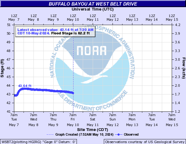
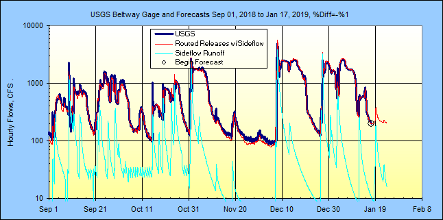
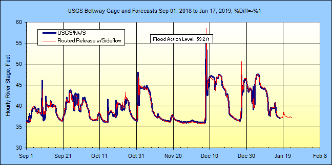
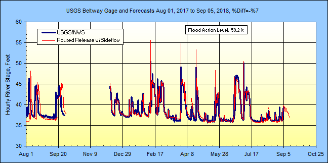
Model and NWS flood stage forecasts West Belt Drive:
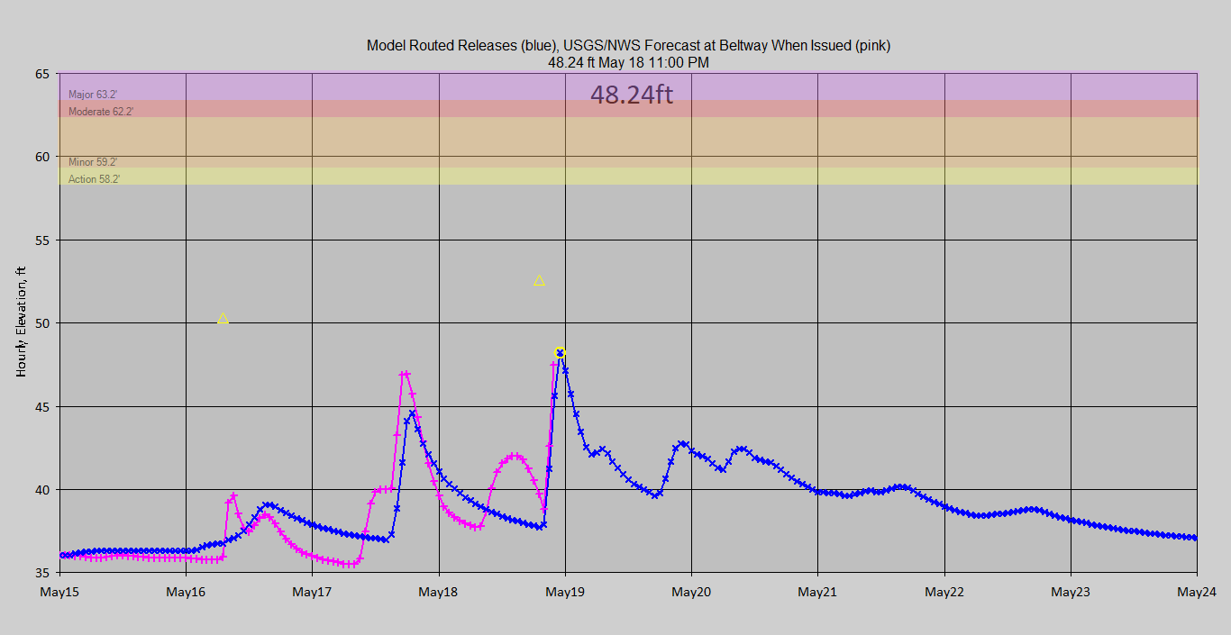
Alert triangles on stage forecasts > 50 ft ... and can be emailed.
My release ratings are based on the Big One of 2017. Almost anything less can be
stored so that only the 35 sqmi side inflow below the 2 reservoirs matter.
Caveat emptor until full. Just keeping you awake.
Looks like for less than hurricane size rainfalls, like the stalled Jun 20, 2018
Tropical Depression, in addition to GetRealtime routing option 'RELEASE 1410 -1
rhour' a low rated flow Modpul should normally be used to project last hours
reservoir release for the next 7 days. One has to remember to use the high flow
modpul rating for projections should a hurricane come into play. My current low
flow modpul rating goes to hurricane levels above a selected high reservoir
level (95 ft) so that may still be a good way to go.
Both Addicks (north reservoir) and Barker (south reservoir) basins were
subdivided into 3 subs:
Addicks s411 reservoir water area, 21.20 sqmi.
Addicks s412 urban area, 63.94 sqmi.
Addicks s413 farm area, 48.27 sqmi.
Barker s421 reservoir water area, 19.31 sqmi.
Barker s422 urban area, 69.70 sqmi.
Barker s423 farm area, 45.20 sqmi.
Area below Dams at Beltway USGS gage s408, 35.0 sqmi. (NWS Flood Forecast Point)
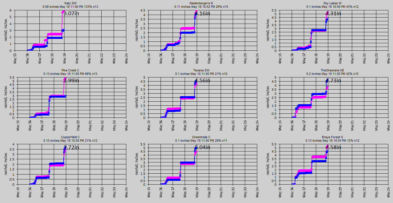
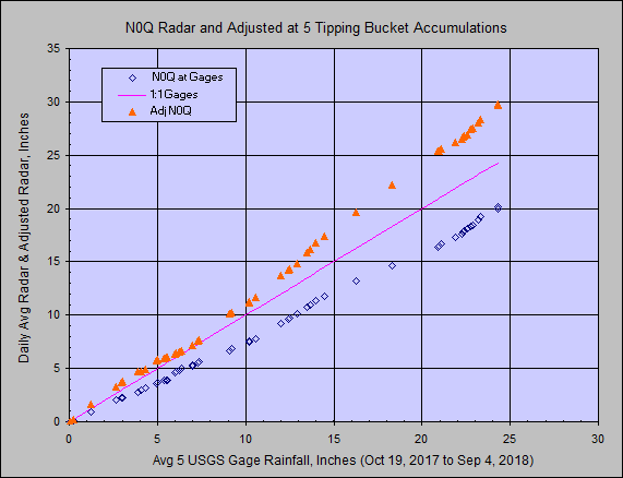
Nine Wunderground rain gages were used to adjust the HGX radar N0Q product.
Several USGS rain gages are available for comparison but are not real-time and
were not used. I hope the basin size is not to large for a single or even
2 G/R ratios so we shall see. Update Nov 1, 2017: The 2 G/R ratios seemed
to be over estimating the adjusted radar rainfall so 5 G/R ratios are now being
used with the 9 Wundergages as Sub 1's and below and each of the other 4 subs.
(results much better)
Update 6/20/2018: The 5 ratios were replaced with 2 ratios, 9
Wundergages for Below Reservoirs and Subs 1 & 2 in both reservoirs. 5
Wundergages used for Subs 3 in both reservoirs. The period 6/9 to 6/20/2018 was
rerun with very little difference. The adjusted radar (9 Wgages) at 5 USGS gages
are now being evaluated instead of 2 USGS gages vs a whole subbasin with much
better correlation but are still over estimating the USGS gages. The
single subbasin below the reservoirs probably need a separate ratio adjustment
with 2 GOOD Wundergages will be looked at next but will be back where I started.
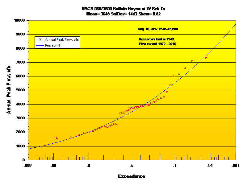
Update 12/08/2018: The peak below the reservoirs was a
2000 year flood while the rainfall was a 3 year event. Changing the Curve
Number for the below res basin to match the peak was unrealistic. Instead
of using an off the shelf 35 sqmi basin boundary below the
reservoirs, I re-digitized catchments with Google Earth Pro and and got a
22.4 sqmi subbasin. I lowered the Curve Number loss from 70 to 64 and increased
the Clark unit graph storage factor from 1.5 to 3.5. Still needs broken in to 2 subs but that's
another day.
Now the model matches the USGS peak and the 3 year rain produces a 6 year
flood. Also my basin total sqmi of 290 matches the USGS.
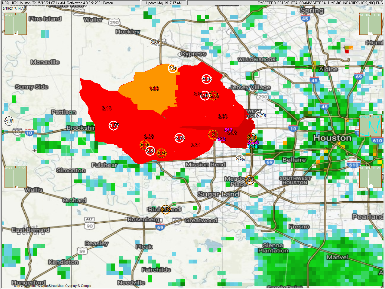
Last real-time radar image monitoring with my free GetNexrad:
(today and yesterday sums red=adj basin radar, white=Wundergages, orange=dead or
USGS gages, black circled=turned OFF, violet=USGS max flow, blue=Model max flow, radar cells are 0.6
miles wide)
Intellicast
big picture Current Texas Gulf Radar Loop:

If you need data from the database sent to your web page sort of like this data table,
then GetRealtime can shell my free GetFromAccessNow:
Current real-time monitoring graphs with my free GetGraphs in my Pacific
time:
Rainfall Forecasts:
The 6-hour block 7-day NWS forecasts are distributed to 5-minutes using my Vegas
distribution and nowcasts based on winds aloft are limited to next 3 hours with
3 addionial hours using HRRR multi radar multi sensor radar forecasts.
My 3-hr Nowcasts are being evaluated on my
web page here.
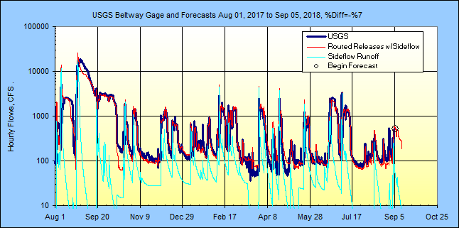
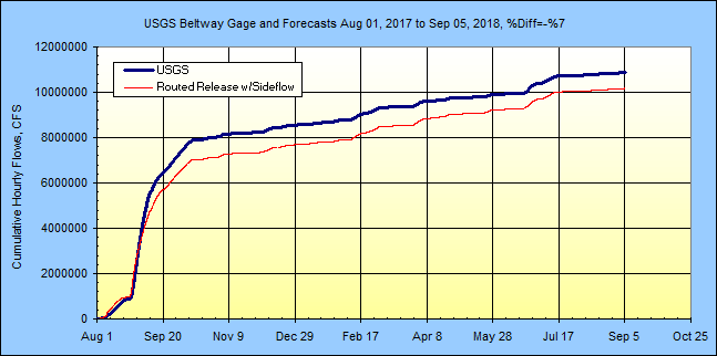
Beltway gage flows P=annual flood recurrence interval in years:
(all graphs pink colored series is the second
source referred to so the pink
here is raw radar w/nowcast)
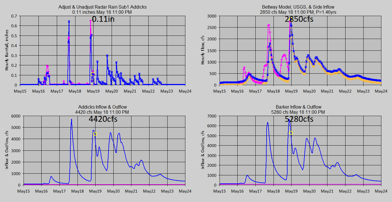
One of many Barker inflow channels:
(Tributary
collector 1 mile upstream of Buffalo Bayou below Katy, flow away from
camera...usually?)

Addicks forebay
and tailrace:
/ASI.LatestImage()/?size=full)
/ASI.LatestImage()/?size=full)
Barker forebay
and tailrace:
/ASI.LatestImage()/?size=full)
/ASI.LatestImage()/?size=full)
=========================================
More Current Info in my Pacific Time Zone.....
=========================================
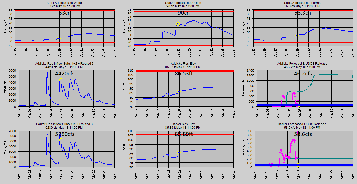
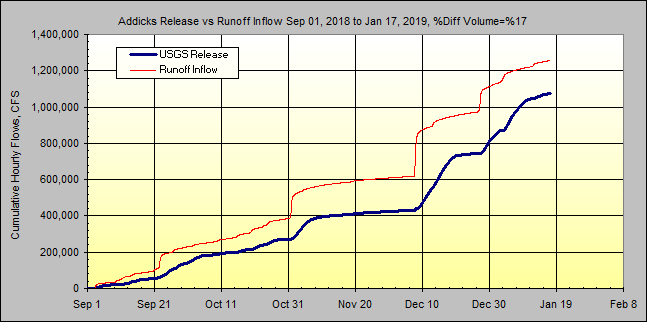
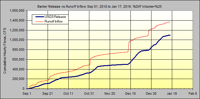
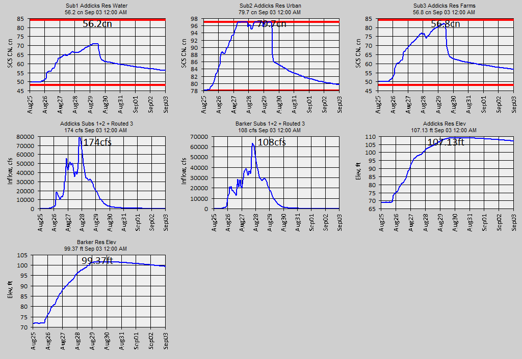
Soil SCS curve numbers, total reservoir inflows, elevations, and forecast
realeses:
Wundergages and raw radar rainfall
with weighted mean absolute % error:
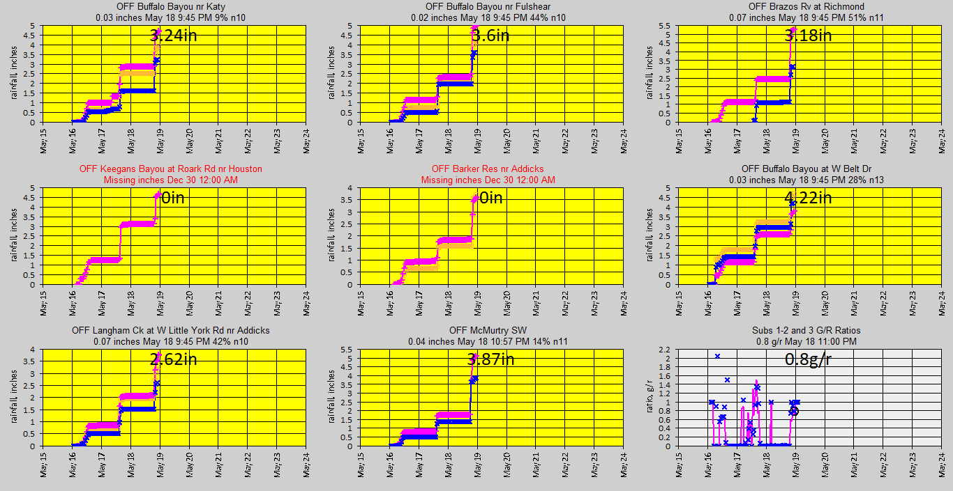
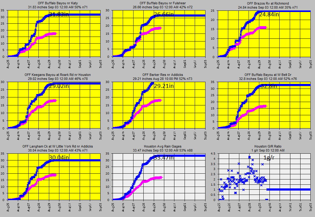
USGS raingages (not used) and raw radar and G/R adjustment ratios:
Adusted Radar
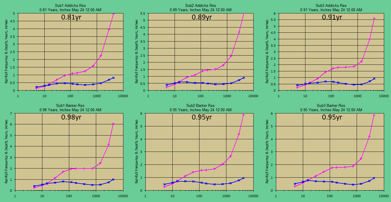
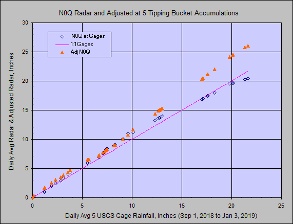
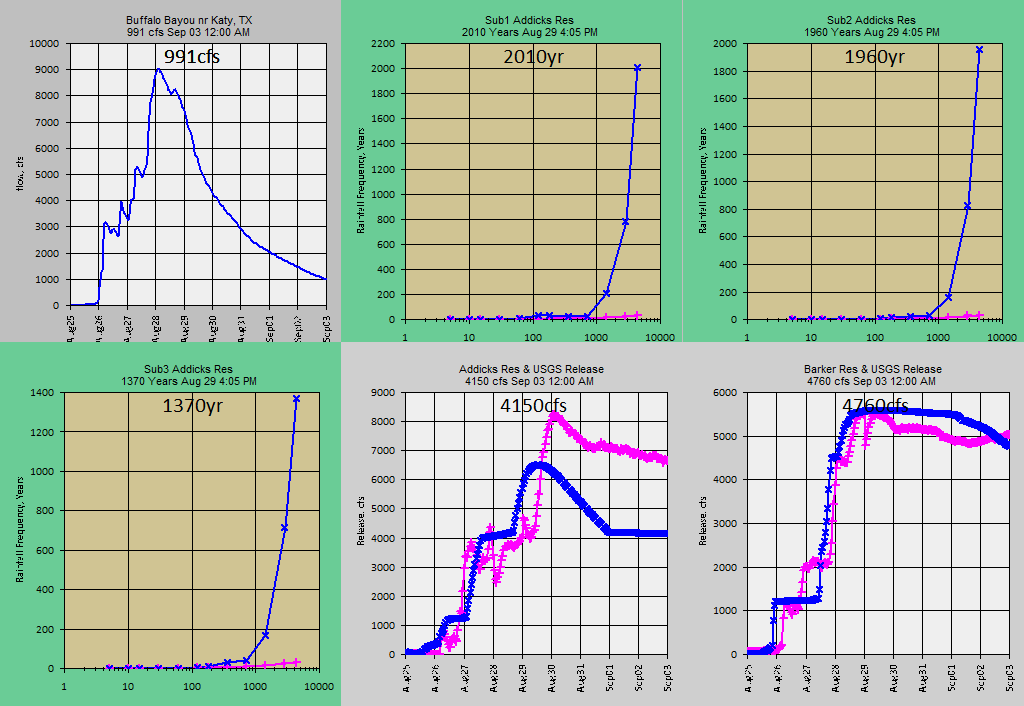
Rainfall frequencies and depths at each subbasn:
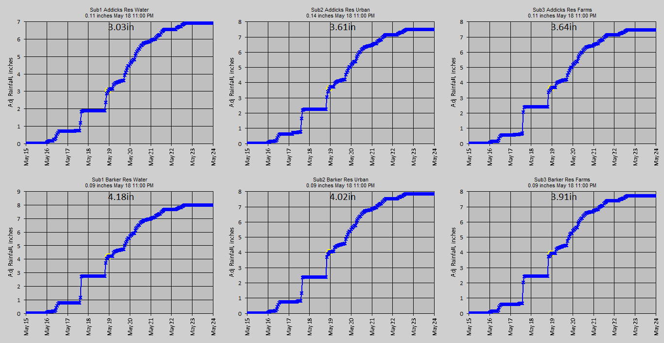
Adjusted radar rainfall and forecast at the subbasins:
Longer Term Info Sep 1, 2018 to ... :
Hourly Adjusted 5 Point Radar vs 5 USGS Gage Average:
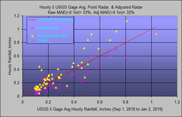
5 Point Adjusted Radar at Gages Avg vs 5 USGS Gage Avg:
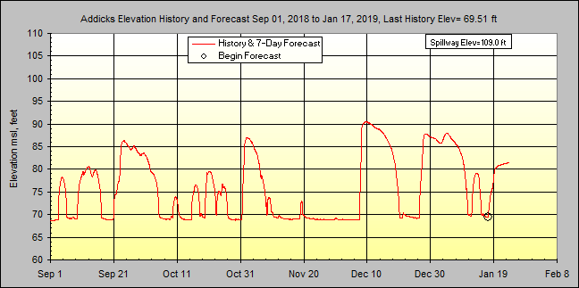
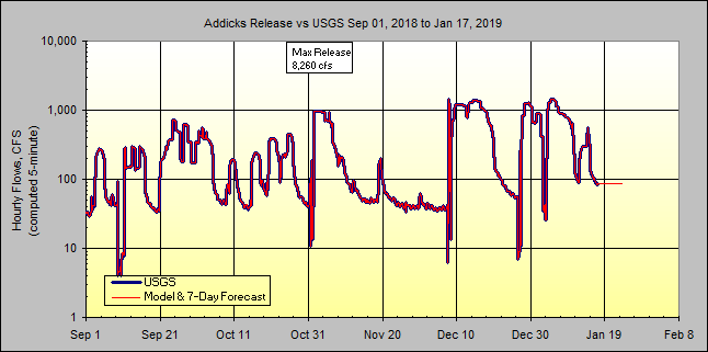
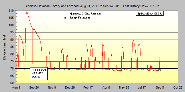
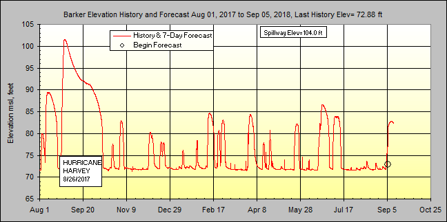
Addicks Elevations and Releases...
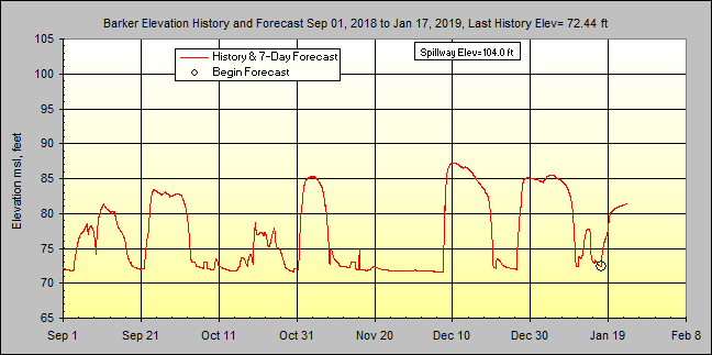
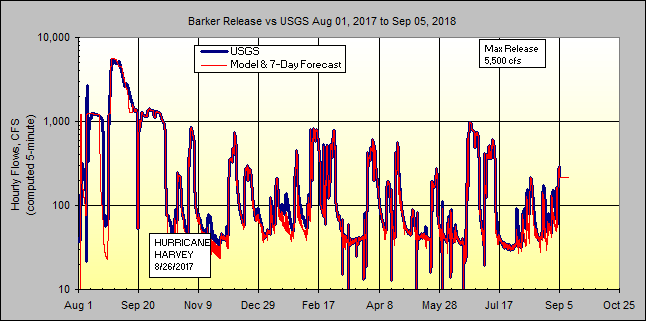
Barker Elevations and Releases...
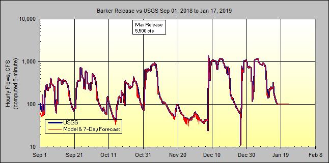
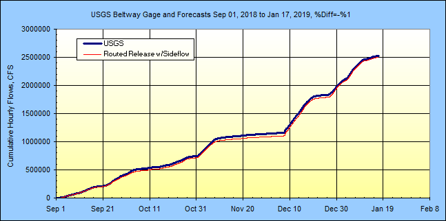
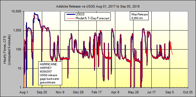
Beltway USGS gage w/NWS forecast and Routed Releases Forecast...
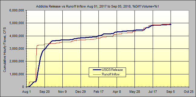
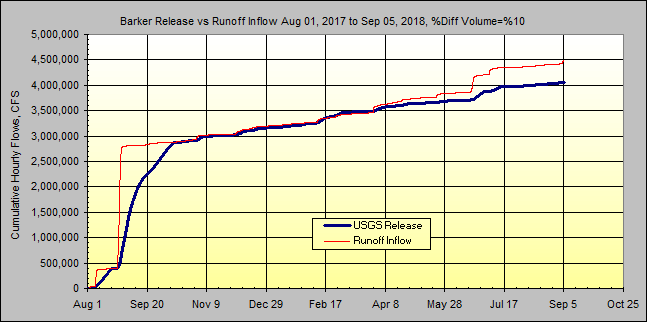
Longer Term Info Aug 1, 2017 to Sep 1, 2018:
Hourly Adjusted 5 Point Radar vs 5 USGS Gage Average:
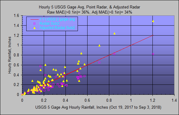
5 Point Adjusted Radar at Gages Avg vs 5 USGS Gage Avg:
Addicks Elevations and Releases...
Barker Elevations and Releases...
Beltway USGS gage w/NWS forecast and Routed Releases Forecast...
Hurricane Harvey Calibrations Aug 1 to Sep 18, 2017
The elevation-release-capactiy tables for the 2 reservoirs were constructed
(cough) using actual operation data for August 1 to Sep 18, 2017 USGS pool
elevations and downstream flow stations. The storage and release were used
to calibrate the runoff coefficients for the 3 subbasins in each reaservoir.
Real-time forecasts of storage and release for the next 7 days by GetRealtime
uses the actual starting pool elevation and current release if less than my
constructed release rating here. The intent is to use current USGS release
value as next 7-day schedule but allow for higher forecast releases for forecast
storm runoff inflow. GetRealtime routings have several options on how to operate
a Modpul rating with scheduling.
I would be happy to send anyone all my database data and setups if they would
like to put some more refinement effort into any part of this for their own use.
I think the Barker calibrations worked out better because of possible less of
less gage backwater. You can see I never got all the rain volume that
releases show out of Addicks.
Also I had to compute the missing Addicks releases for the peak period (I think
the USGS is updating the rating and may fill it in so that might help a lot).
Update: Now that I think about it, I was trying to kill 2 birds with one
run... both calibrate the runoff inflows and develope a release rating. I
should have set the releases with my RELEASE method to use USGS actual releases
to calibrate the runoff inflows to match pool elevations AND THEN run and jiggle
the Modpul release rating to some what match the USGS elevs and releases.
Seems ok for now so there's always the next project... and Wunderground rain
gage graph 6 below should have been turned off... do you see why?
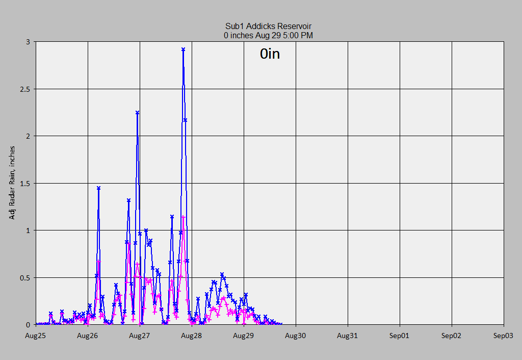
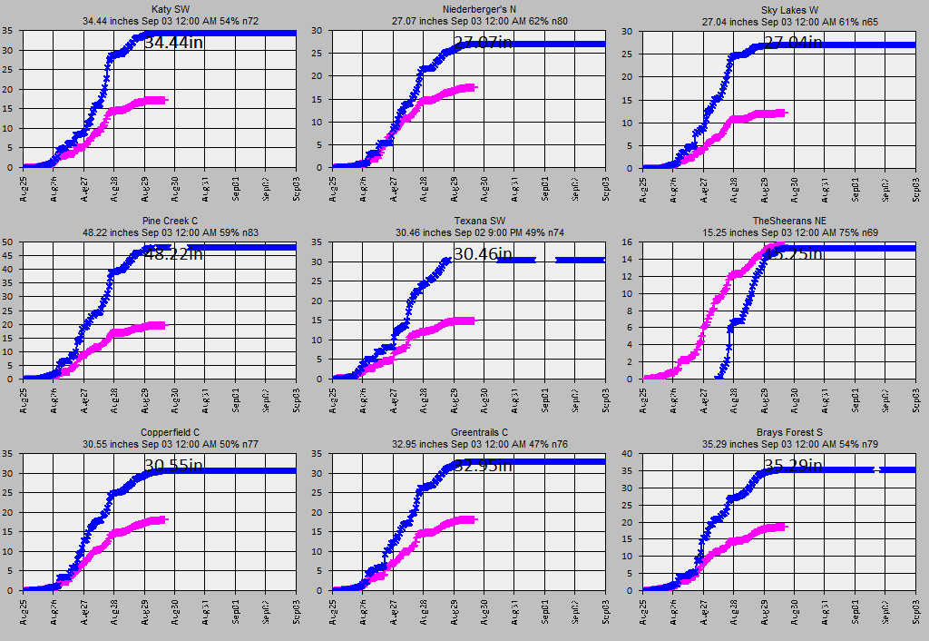
Addicks Subbasin 1 adjusted and raw radar rainfall:
Wunderground rainfall gages and raw radar (uh oh, notice graph 6 TheShreerans NE
gage was down):
USGS rainfall gages for comparison (not used) and raw radar:
3-day rainfall recurrences woooweeee!; model and USGS reservoir releases:
Model soil, release, and reservoir elevation:
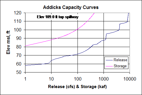
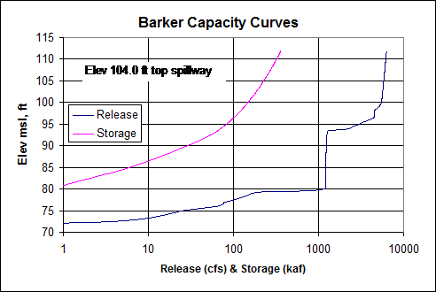
A guesstimate of Addicks and Barker Release curves; Storage USACE Survey
date 2008-10-01:
NON-Log Pearson III (logs were +6 skewed):
Texas has no Atlast 14 yet so this Atlas 14 table is for a point at the Louisana
state border near Interstate 210.
Just over the LA border on the Freeway--Carson
Point precipitation frequency estimates (inches)
NOAA Atlas 14 Volume 9 Version 2
Data type: Precipitation depth
Time series type: Partial duration
Project area: Southeastern States
Location name (ESRI Maps): Vinton Louisiana USA
Station Name: - Latitude: 30.1395° Longitude: -93.6182°
Elevation (USGS): 2.49 ft
PRECIPITATION FREQUENCY ESTIMATES by duration for ARI (years):
1 2 5 10 25 50 100 200 500 1000
5-min: 0.585 0.663 0.79 0.894 1.04 1.15 1.25 1.36 1.5 1.61
10-min: 0.857 0.971 1.16 1.31 1.52 1.68 1.84 1.99 2.2 2.36
15-min: 1.05 1.18 1.41 1.6 1.85 2.05 2.24 2.43 2.69 2.88
30-min: 1.56 1.76 2.09 2.37 2.76 3.08 3.4 3.73 4.17 4.52
60-min: 2.09 2.35 2.8 3.21 3.82 4.32 4.85 5.43 6.23 6.88
2-hr: 2.62 2.94 3.52 4.05 4.87 5.56 6.31 7.12 8.29 9.24
3-hr: 2.96 3.33 4.03 4.69 5.71 6.6 7.56 8.63 10.2 11.4
6-hr: 3.53 4.07 5.08 6.03 7.5 8.78 10.2 11.7 13.9 15.7
12-hr: 4.13 4.92 6.34 7.66 9.67 11.4 13.2 15.3 18.2 20.5
24-hr: 4.84 5.79 7.52 9.13 11.6 13.7 15.9 18.4 21.9 24.8
2-day: 5.69 6.67 8.5 10.2 12.9 15.2 17.7 20.5 24.5 27.8
3-day: 6.16 7.25 9.23 11.1 13.9 16.3 19 21.8 25.9 29.3
GetRealtime_setup.txt info:
Future Days=5
Percent Missing Allowed= 100%
Write Dailys= True
Write Hourly Avg= True
Write Daily Max= True
Write Unit Values= True
Write Unit Shifts= False
Overwrite Protected Source 5= True
Check for Possible Bad Values= False
Possible Bad Value Change= 200%
Last Runoff Run's Storage= True
Minutes between retrievals=60
Max hours of radar=4
Save Radar greater than= False
Beep on Save= True
Delete temporary internet files=True
Loop radar boundaries=True
Use Nexrad Ridge1 full web file listing=False
Use Nexrad short web file listing=False
Use Nexrad Ridge2 Iowa State Mesonet=True
Use Nowcast 70R30 line=False
Compact and Backup HDB at midnight= True
GetAccess.exe folder=C:\FFS\BUFFALODAMS\GETACCESS\
GetGraphs.exe folder=C:\FFS\BUFFALODAMS\GETGRAPHS\
GetNexrad.exe folder=C:\FFS\BUFFALODAMS\GETNEXRAD\
NowCast Info folder=C:\FFS\BUFFALODAMS\GETNEXRAD\
Gage Avg OnOff folder=
Radar Boundary File folder=C:\FFS\BUFFALODAMS\GETREALTIME\BOUNDARIES\
Menu Pic=C:\FFS\BUFFALODAMS\GETREALTIME\ADDICKS.JPG
Menu Text Color= 0
Minimize to System Tray=True
Column Widths=1395,1620,840,2910,555,4395,6870
Alert Address=
Alert Address CC=
Alert Address BCC=
Alert Start Time=-1
Don't Ask Questions=True
Create Winds Aloft graphic file=True
Metric Units=False
Database Connection String=Provider=Microsoft.Jet.OLEDB.4.0;Data
Source=C:\FFS\BuffaloDams\GetAccess\GetAccessHDB.mdb;User Id=admin;Password=;
Station_ID; Datatype_Site_ID; Datatype_Name; Site_Name; base1; shift1; formula1;
base2; shift2; formula2; base3; shift3; formula3
******; ******; ******; ******NWS Forecast Flow (includes 26 sqmi side
inflow)********
FORECAST-NWS,wsbt2; 1409; Forecast Flow; USGS Beltway Gage Flows below
Reservoirs
******; ******; ******; ******USGS**********************
08073600; 1409; Flow; USGS Flows below Reservoirs at Beltway
08073100, 5min; 1410; Flow; Langham Ck at Addicks Res Outflow
08072600, 5min; 1420; Flow; Buffalo Bayou at Barker Res Outflow
08073000, 5min;
2411; Elev; Addicks Res nr Addicks, TX
08072500, 5min; 3421; Elev; Barker Res nr Addicks, TX
******; ******; ******; ******USGS Rainfall
display only*******************
08072300; 10203; Rainfall; Buffalo Bayou nr Katy
08072350; 10204; Rainfall; Buffalo Bayou nr Fulshear
08114000; 10205; Rainfall; Brazos Rv at Richmond
08074800; 10206; Rainfall; Keegans Bayou at Roark Rd nr Houston
08072500; 10207; Rainfall; Barker Res nr Addicks
08073600; 10208; Rainfall; Buffalo Bayou at W Belt Dr
08072760; 10209; Rainfall; Langham Ck at W Little York Rd nr Addicks
08074150; 10210; Rainfall; Cole Ck at Deihl Rd
******; ******; ******; ******Wundergages
Rainfall**********************
KTXKATY149; 10301; Rainfall; Katy SW
KTXCYPRE74; 10302; Rainfall; Niederberger's NW Cypress
KTXWALLE17; 10303; Rainfall; Sky Lakes W
KTXCYPRE194; 10304; Rainfall; Pine Creek C
KTXFULSH20; 10305; Rainfall; Fulshear SW
KTXWINCH2; 10306; Rainfall; Thesheerans NE
KTXHOUST789; 10307; Rainfall; Copperfield C
KTXHOUST820; 10308; Rainfall; Greentrails C
KTXHOUST1979; 10309; Rainfall; Brays Forest S
******; ******; ******; ******NWS Forecast**********************
Run-FORECAST-NWS; -11411; Forecast Rain; Addicks S1; -2; 29.791,-95.734, 3
FORECAST-NWS; -11412; Forecast Rain; Addicks S2; -2; 29.791,-95.734, 3
FORECAST-NWS; -11413; Forecast Rain; Addicks S3; -2; 29.791,-95.734, 3
FORECAST-NWS; -11421; Forecast Rain; Barker S1; -2; 29.791,-95.734, 3
FORECAST-NWS; -11422; Forecast Rain; Barker S2; -2; 29.791,-95.734, 3
FORECAST-NWS; -11423; Forecast Rain; Barker S3; -2; 29.791,-95.734, 3
******; ******; ******; ******Radar
N0Q**********************
NEXRAD-HGX; -10411; Rainfall; Addicks Sub1 Reservoir Water; 0; nowcast 3, type 3
NEXRAD-HGX; -10412; Rainfall; Addicks Sub2 Housing; 0; nowcast 3, type 3
NEXRAD-HGX; -10413; Rainfall; Addicks Sub3 Farms; 0; nowcast 3, type 3
NEXRAD-HGX; -10421; Rainfall; Barker Sub1 Reservoir Water; 0; nowcast 3, type 3
NEXRAD-HGX; -10422; Rainfall; Barker Sub2 Housing; 0; nowcast 3, type 3
NEXRAD-HGX; -10423; Rainfall; Barker Sub3 Farms; 0; nowcast 3, type 3
NEXRAD-HGX; -10301; Rainfall; Katy SW; 0
NEXRAD-HGX; -10302; Rainfall; Niederberger's NW Cypress; 0
NEXRAD-HGX; -10303; Rainfall; Sky Lakes W; 0
NEXRAD-HGX; -10304; Rainfall; Pine Creek C; 0
NEXRAD-HGX; -10305; Rainfall; Fulshear SW; 0
NEXRAD-HGX; -10306; Rainfall; Thesheerans; 0
NEXRAD-HGX; -10307; Rainfall; Copperfield; 0
NEXRAD-HGX; -10308; Rainfall; Greentrails; 0
NEXRAD-HGX; -10309; Rainfall; Brays Forest; 0
NEXRAD-HGX; -10203; Rainfall; Buffalo Bayou nr Katy; 0
NEXRAD-HGX; -10204; Rainfall; Buffalo Bayou nr Fulshear 0
NEXRAD-HGX; -10205; Rainfall; Brazos Rv at Richmond; 0
NEXRAD-HGX; -10206; Rainfall; Keegans Bayou at Roark Rd nr Houston; 0
NEXRAD-HGX; -10207; Rainfall; Barker Res nr Addicks; 0
NEXRAD-HGX; -10208; Rainfall; Buffalo Bayou at W Belt Dr; 0
NEXRAD-HGX; -10209; Rainfall; Langham Ck at W Little York Rd nr Addicks; 0
NEXRAD-HGX; -10210; Rainfall; Cole Ck at Deihl Rd; 0
******; ******; ******; ******HRRR Forecast**********************
Run-Forecast-HRRR; -11411; Forecast Rain; Addicks S1; 0; 29.791,-95.734, 6
Forecast-HRRR; -11412; Forecast Rain; Addicks S2; 0; 29.791,-95.734, 6
Forecast-HRRR; -11413; Forecast Rain; Addicks S3; 0; 29.791,-95.734, 6
Forecast-HRRR; -11421; Forecast Rain; Barker S1; 0; 29.791,-95.734, 6
Forecast-HRRR; -11422; Forecast Rain; Barker S2; 0; 29.791,-95.734, 6
Forecast-HRRR; -11423; Forecast Rain; Barker S3; 0; 29.791,-95.734, 6
******; ******; ******; ******G/R Ratios**********************
COMPUTE-Hour; 10401; Rainfall; Houston Avg Rain Gages; 0; 0;
(P1+P2+P3+P4+P5+P6+P7+P8+P9)/N
COMPUTE-Hour; -10401; Rainfall; Houston Avg Radars; 0; 0;
(P1+P2+P3+P4+P5+P6+P7+P8+P9)/N
Run-COMPUTE-Hour; 31401; Ratio; Houston G/R Ratio; 0; 0.01, 1.0, 5; P1/P2
******; ******; ******; ******Adjusted Radar**********************
COMPUTE; -11411; Adjusted Rain; Addicks Sub1; 0; -1, 1.0, 0.3, 0.80; P1*P2
COMPUTE; -11412; Adjusted Rain; Addicks Sub2; 0; -1, 1.0, 0.3, 0.80; P1*P2
COMPUTE; -11413; Adjusted Rain; Addicks Sub3; 0; -1, 1.0, 0.3, 0.80; P1*P2
COMPUTE; -11421; Adjusted Rain; Barker Sub1; 0; -1, 1.0, 0.3, 0.80; P1*P2
COMPUTE; -11422; Adjusted Rain; Barker Sub2; 0; -1, 1.0, 0.3, 0.80; P1*P2
COMPUTE; -11423; Adjusted Rain; Barker Sub3; 0; -1, 1.0, 0.3, 0.80; P1*P2
******; ******; ******; ******GRT Runoff **********************
COMPUTE; -30411; RUNOFF; Addicks Reservoir Water; 0; 1, 50, 0.10, 30, 21.20,
0.4, 0.3, 0.5, 1.5, 0.2, 3.0, 84, 48, .8, 0.2, 3.5, 0.2, 0.8, 0.03, 1, 0, 0.2,
0, 0.7, -1, LagV; P1; 1.5; Clark UGF
COMPUTE; -30412; RUNOFF; Addicks Housing; 0; 4, 82, 0.10, 20, 63.94, 0.4, 0.3,
0.5, 1.5, 0.2, 3.0, 97, 78, .8, 0.2, 3.5, 0.2, 0.8, 0.03, .8, 0, 0.2, 0, 0.7,
-1, LagV; P1; 1.5; Clark UGF
COMPUTE; -30413; RUNOFF; Addicks Farms; 0; 6, 50, 0.10, 1, 48.27, 0.4, 0.3, 0.5,
1.5, 0.2, 3.0, 84, 48, 0.8, 0.2, 1, 0.2, 0.8, 0.03, 1, 0, 0.2, 0, 0.7, -1, LagV;
P1; 1.5; Clark UGF
COMPUTE; -30421; RUNOFF; Barker Reservoir Water; 0; 1, 50, 0.10, 30, 19.31, 0.4,
0.3, 0.5, 1.5, 0.2, 3.0, 84, 48, .8, 0.8, 3.5, 0.2, 0.8, 0.03, 1, 0, 0.2, 0,
0.7, 0, LagV; P1; 1.5; Clark UGF
COMPUTE; -30422; RUNOFF; Barker Housing; 0; 5, 82, 0.10, 20, 69.7, 0.4, 0.3,
0.5, 1.5, 0.2, 3.0, 97, 78, .8, 0.5, 3.5, 0.2, 0.8, 0.03, .8, 0, 0.2, 0, 0.7, 0,
LagV; P1; 1.5; Clark UGF
COMPUTE; -30423; RUNOFF; Barker Farms; 0; 8, 50, 0.10, 1, 45.2, 0.4, 0.3, 0.5,
1.5, 0.2, 3.0, 84, 48, 0.8, 0.8, 1, 0.2, 0.8, 0.03, 1, 0, 0.2, 0, 0.7, 0, LagV;
P1; 1.5; Clark UGF
******; ******; ******; ******GRT Routings **********************
ROUTE; -1413; Flow; Addicks Farms 3 to Res
Compute; -24411; Inflow; Addicks Subs 1+2 + Routed 3; 0; 0; P1+P2+P3
ROUTE; -1411; Release; Addicks Res Mopul
ROUTE; -1423; Flow; Barker Farms 3 to Res
Compute; -24421; Inflow; Barker Subs 1+2 + Routed 3; 0; 0; P1+P2+P3
ROUTE; -1421; Release; Barker Res Mopul
ROUTE; -1409; Flow; Barker + Addicks Releases + Sub 408 Runoff
******; ******; ******; ******Soil **********************
COMPUTE-unit; -6421; SCS CN; Addicks Reservoir Water Soil CN; 0; 0; 1000/(P1+10)
COMPUTE-unit; -6422; SCS CN; Addicks Housing Soil CN; 0; 0; 1000/(P1+10)
COMPUTE-unit; -6423; SCS CN; Addicks Farm Soil CN; 0; 0; 1000/(P1+10)
******; ******; ******; ******USGS Overwrite With History**********************
08073000, 5min; 2411; Elev; Addicks Res nr Addicks, TX
08072500, 5min; 3421; Elev; Barker Res nr Addicks, TX
******; ******; ******; ******SHELL ftp to web **********************
SHELL-C:\FFS\BuffaloDams\GETNEXRAD\GetNexrad.exe -2 mypassword; 0; Pic; Pic of
Radar; 0
SHELL-C:\FFS\BuffaloDams\GETGRAPHS\GetGraphs.exe 4 mypassword; 0; Graphs;
Getgraphs to Web; 0
SHELL-C:\FFS\BuffaloDams\GETGRAPHS\GetFromAccessNOW.exe rdaymax, 10401 -10401
-11412 -11422 2411 3421, -2, 5, HoustonNOW.txt, mypassword; 0; Flow Data to Web;
Put Flow Data Text File on Web; 0
END
GetRealtime reservoir routing file example:
Route Subs 1,2,3 thru Addicks Dam
GET 4 -24411 Subs 1 2 3 inflow unit values
RELEASE 1410 -1 RHOUR use USGS hourlys history and for forecast release if >
rated
ROUTE Modpul 2411 Modpul_Addicks_Rated.Rat -3 0.8 Seldon KS evap*.8, -3 write
elev's on actual start day, not runoff begin
END
Important Note: Nothing on this page is intended as
interpretation of any legal authority such as water rights and supply. This page
is intended solely as a demonstration of techniques in flood potential
monitoring. The reader assumes all risk for any damages whatsoever in connection
with the access, use, quality, or performance of the supplied data just so you
know.
|