|
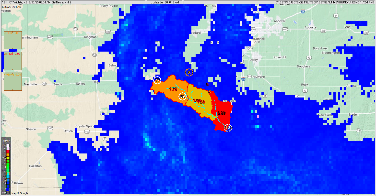
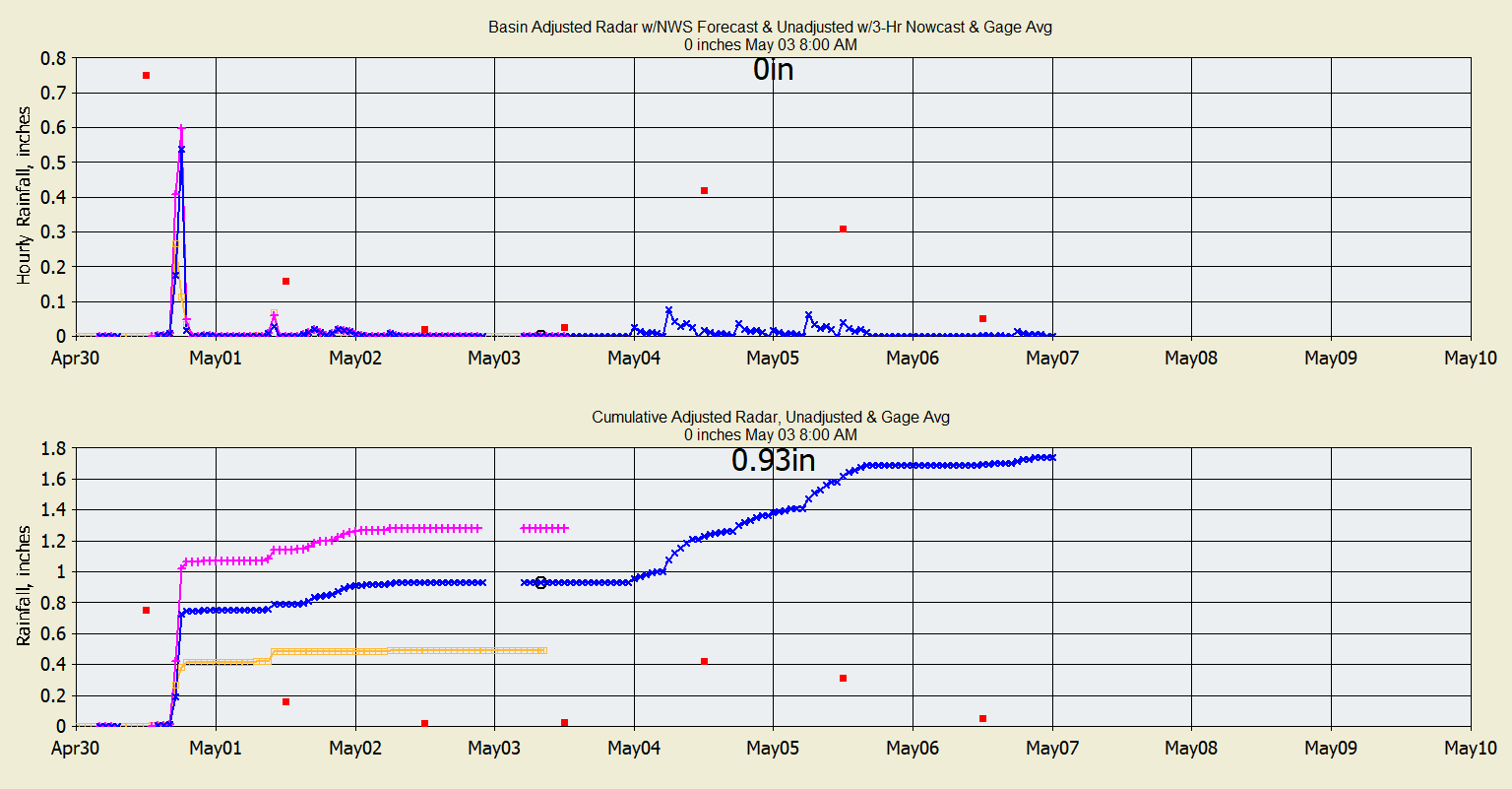
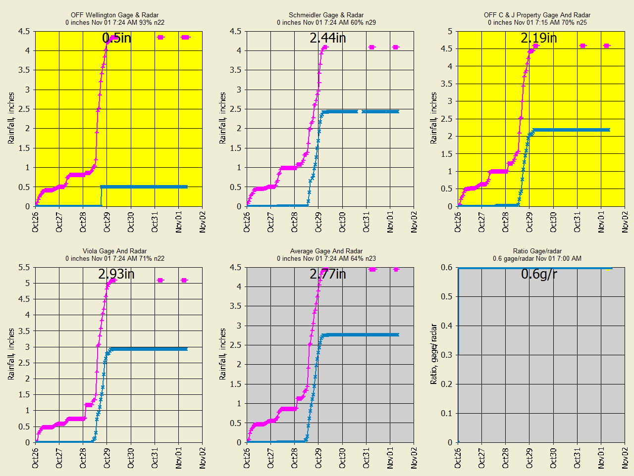
Below is zoomed A2M
hi-res radar rainfall (not dbz), Wundergages, and
adjusted A2M rainfall at the watersheds. Note that the raw A2M radar here almost
never
shows "ground clutter" evan being this close to the radar site.
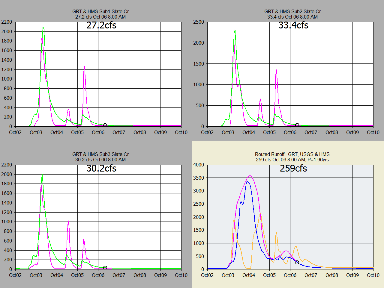
The runoff here is very inconsistant which I think is due to poor rain gages so
I thought I would try A2M instead of N0B but I'm pretty sure adjusting the A2M
with poor rain gages will exactly the same erratic runoff results.
GetRealtime can automate gage adjusted radar
rainfall and snowmelt for EPA-SWMM (or HEC-HMS) model and shell SWMM or HMS and retrieve the
SWMM or HMS
output in realtime. I am NOT
experienced with SWMM or HMS setups for use in real-time for continuous modeling so this
is probably more of how my GetRealtime runoff compares to the USGS gage than a
very well performed SWMM or HMS setup comparison. This study does show that HMS
can be used by more experienced HMS modelers so I'll leave that part up to you.
HEC-RAS was also used for comparison with GRT's Muskingum-Gunge and shows
Unsteady Flow calcs are needed. SWMM is now beting used to replace the HMS
runoff and routing but RAS routing continues for now. SWMM also has
unsteady flow routing but kinematic wave is used to link the catchments unless
noted as RAS.
The Slate Creek basin was subdivided into 3 basins and GRT (GetRealTime)
used Muskingum-Cunge
and SWMM used Kinematic Wave (or HMS used the same channel info for Muskingum-Cunge routings). HMS does
not seem to route very well and is probably due to my operater screw ups.
Again, this study shows HOW to operate HEC-HMS in realtime and not very much on
how to setup HMS. I gave it my best shot. My GRT uses my continuous
soil moisture adjsted SCS Curve Number method. HMS uses just the standard
SCS Curve Number of 64 for the 3 subbasins with simple 0.03" leaf loss and
monthly ET values for doing HEC stuff to the losses what ever that is. My
GRT model uses the same monthly ET values but distribued on an hourly basis over
the year (ET is computed w and w/o gaged Solar for display only here but could
have also been used.
Last model run info from database as text each run
(GetFromAccessNOW.exe):
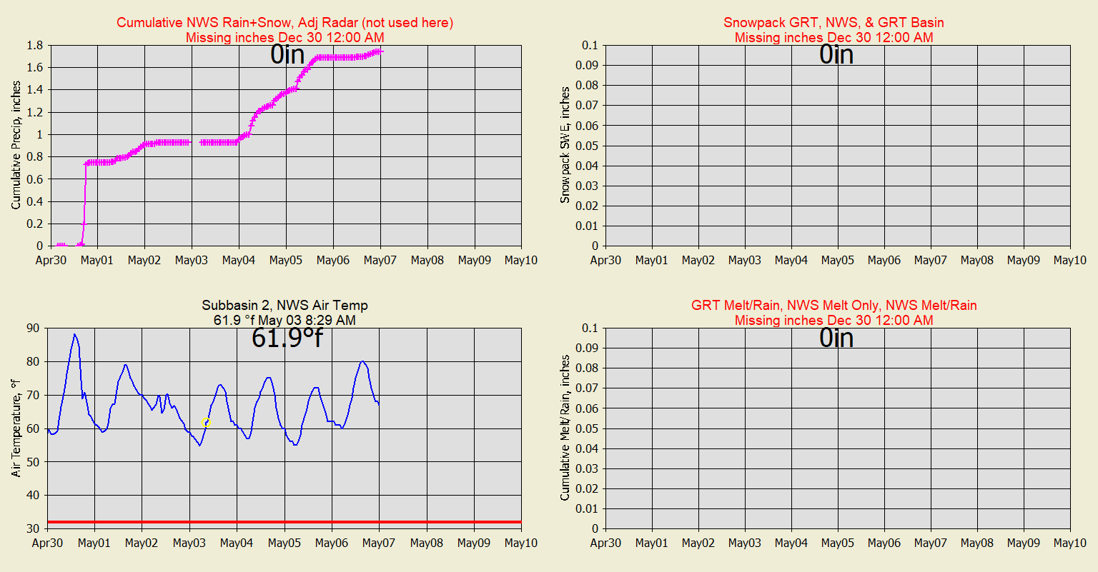
Slate Creek NWS SNOWCAST:

NWS Model Point KS-KM-4 Compared to GRT Using NWS Rain+Snow Precip:
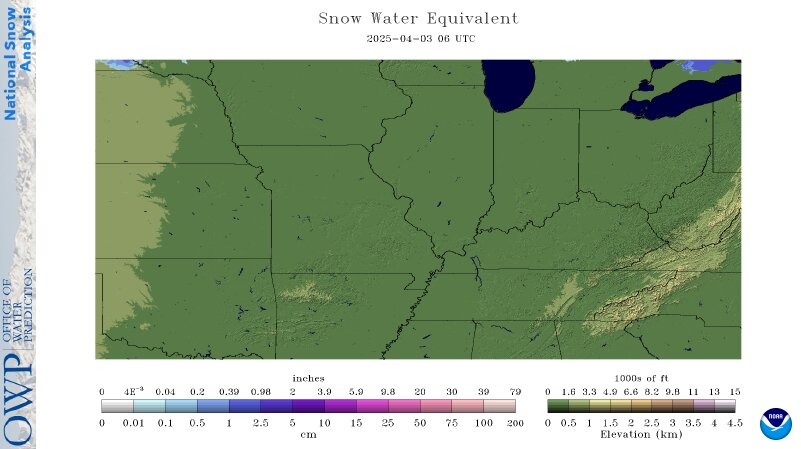
Current NWS snowpack:
NOTE ALL TIMES ARE FOR MY PACIFIC TIME ZONE
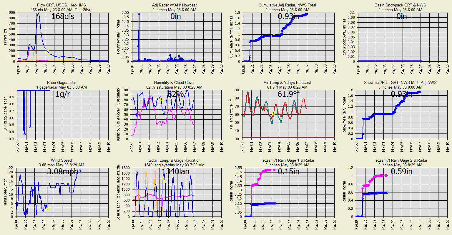
Current automated graphs and radar (updated when runoff)
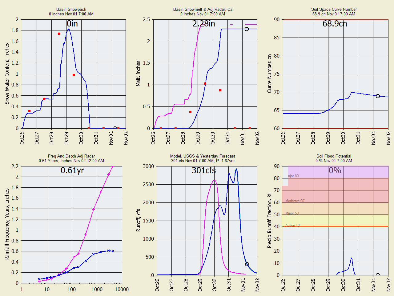
Summary of Snowmelt (Series 1=Blue, Series 2=Pink, Series 3=Orange):
Radar ratio adjusted rainfall and
Wundergages (pink is second source referred to) :
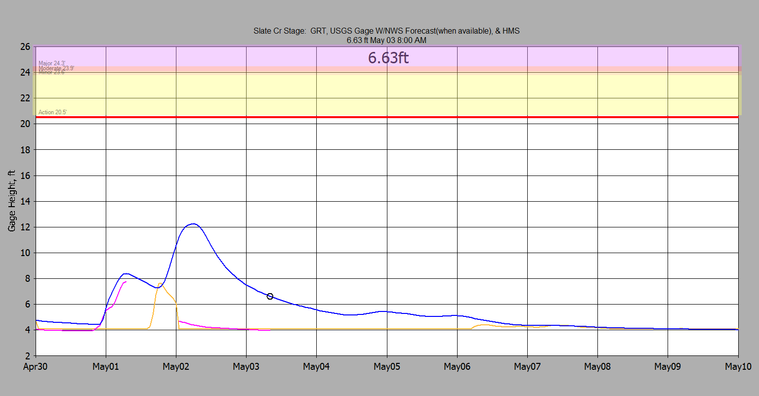
Stage from GRT green, USGS gage pink, & HMS (3rd
source SWMM is orange):
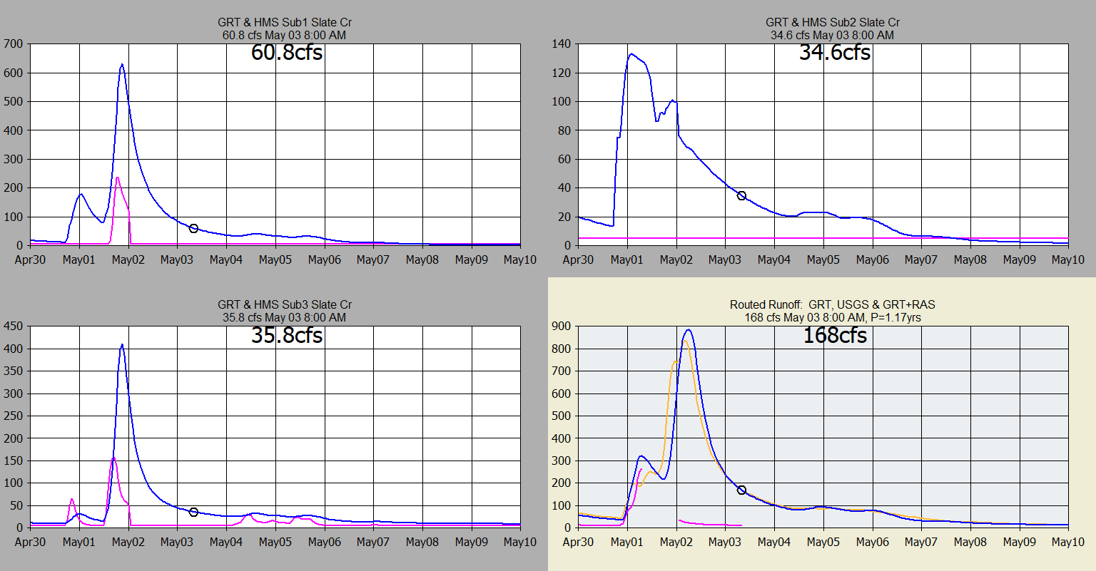
Subbasin runoff
GRT vs SWMM (2nd source is pink, 3rd is orange
HEC-RAS routing):
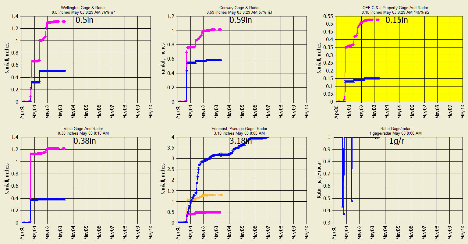
Wundergages and radar ratio adjustment:
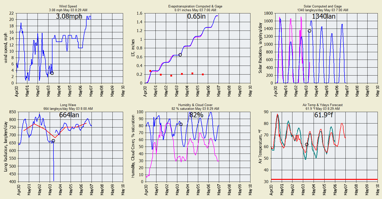
Meteorlogical data from Wundergages for snowmelt and evapotranspiration used by
GRT:
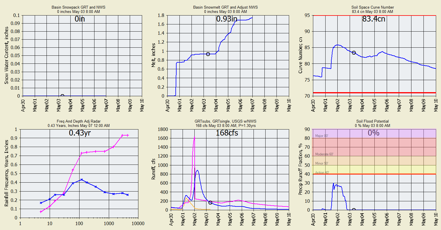
Snowpack and soil moisture info used by GRT:
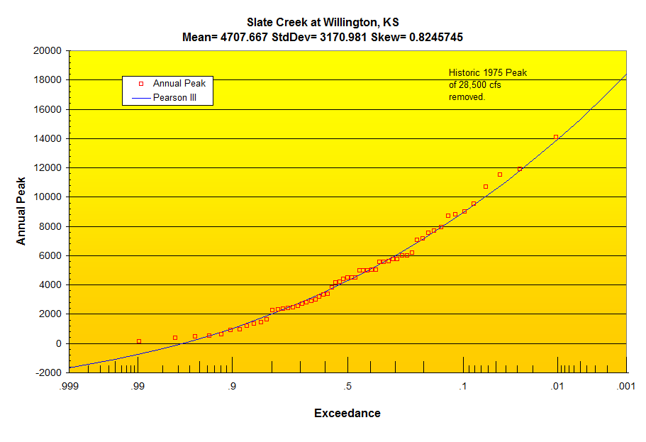
Pearson III Annual Peak Flow Probability Distribution:
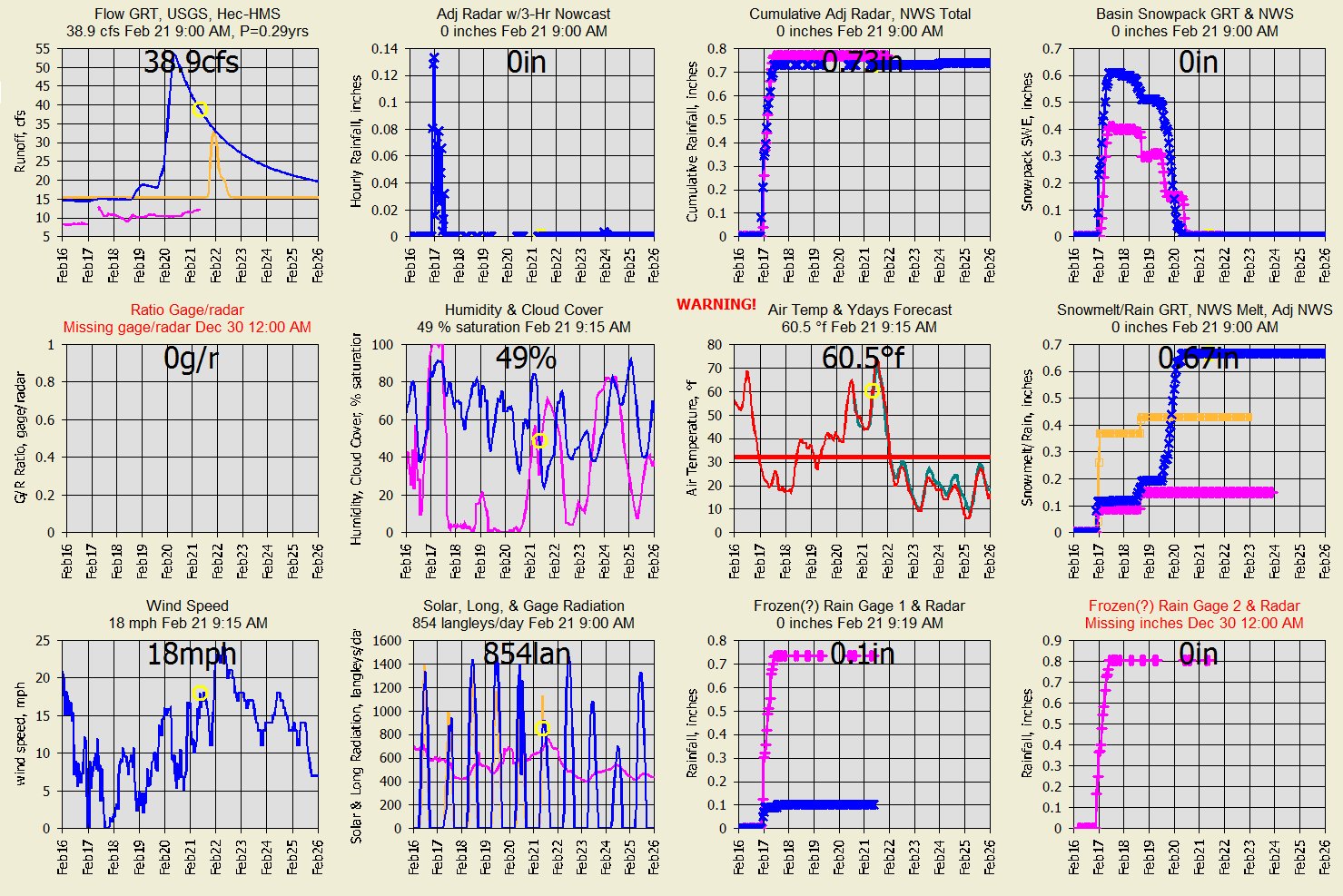
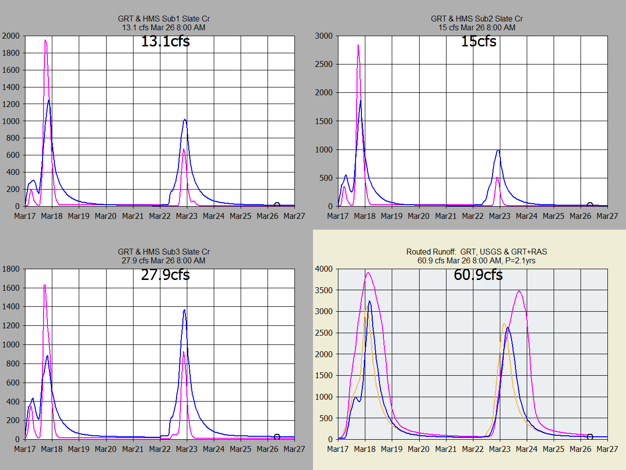
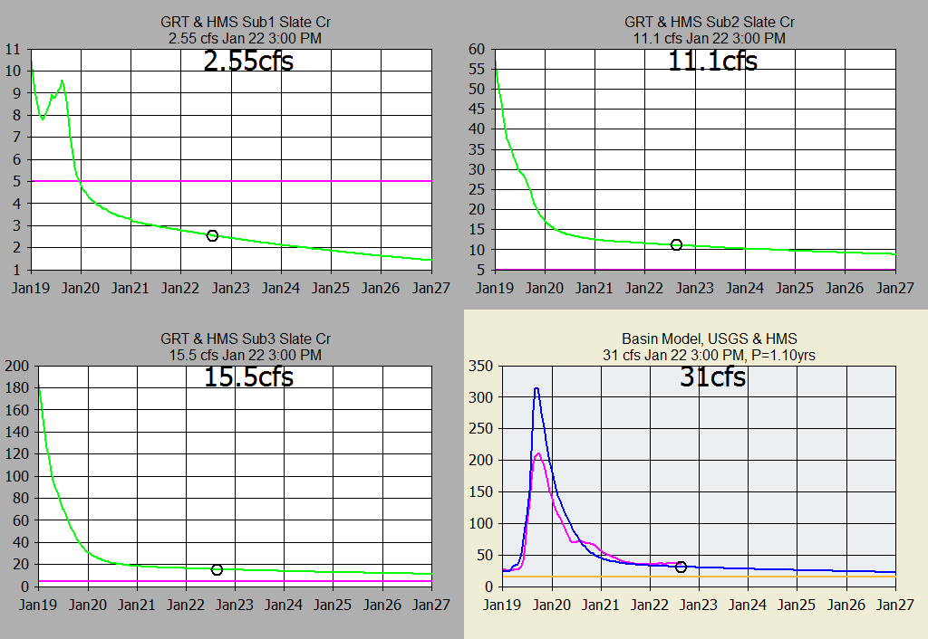
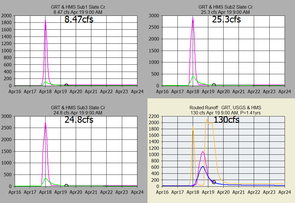
Past runoff and snowpack comparisons for the 3 subs and routed basin runoff:
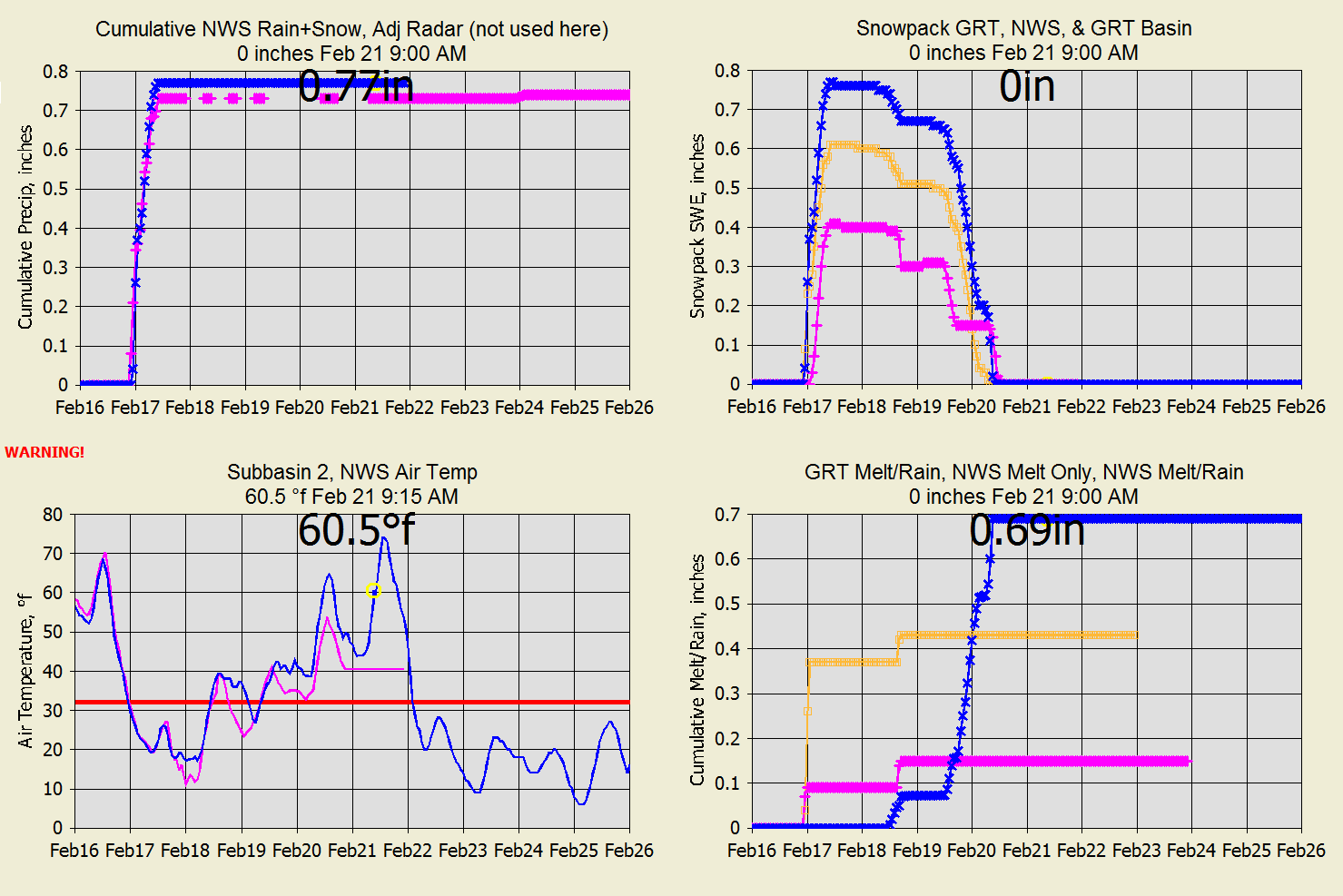
Snowpack comparison with NWS snow Feb 2022:
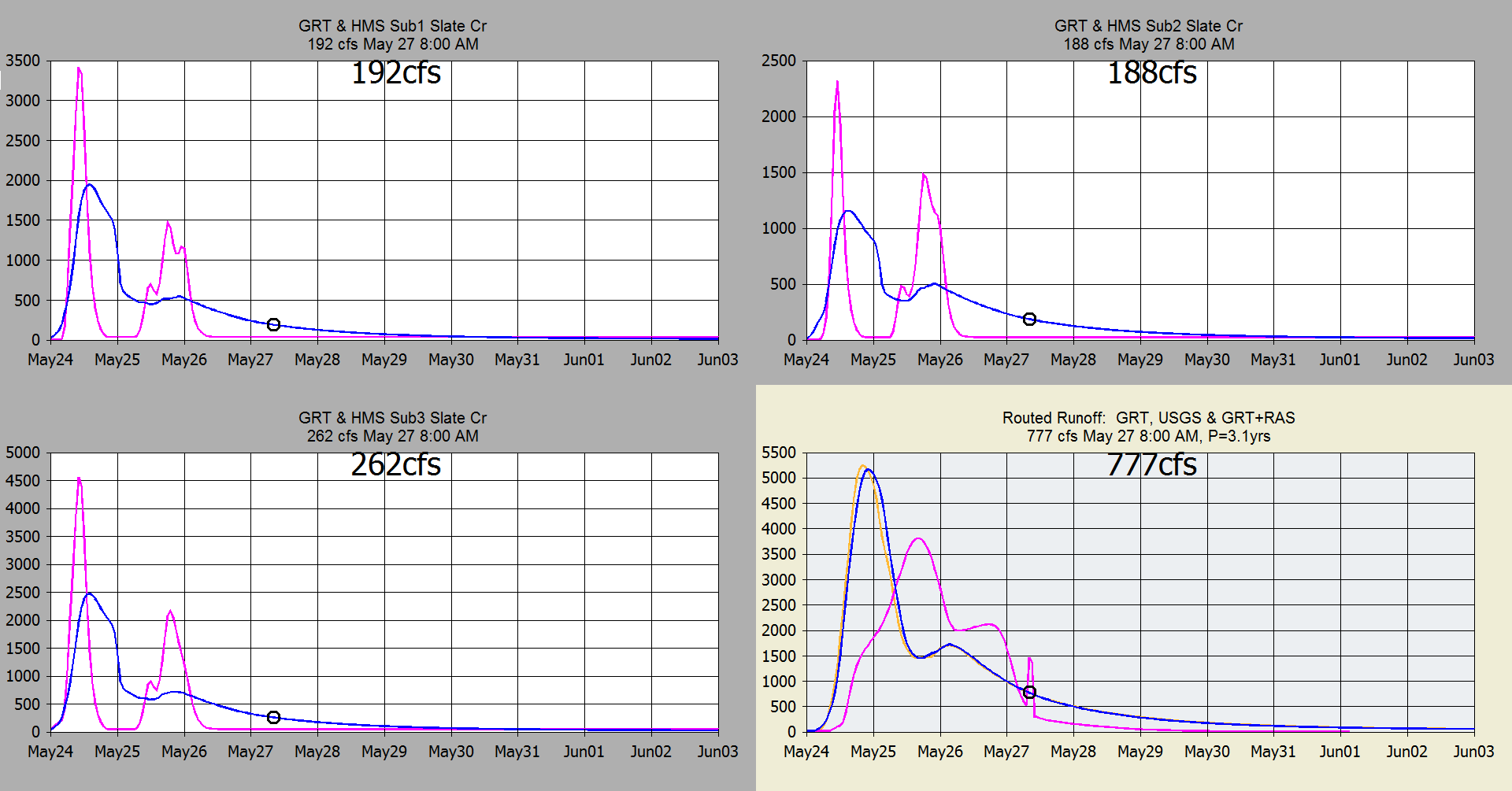
GRT (blue) muskingum-cunge routing comparison to GRT runoff with Hec-Ras (gold)
unsteady flow routing (channel slope 4 ft/mi).
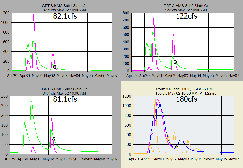
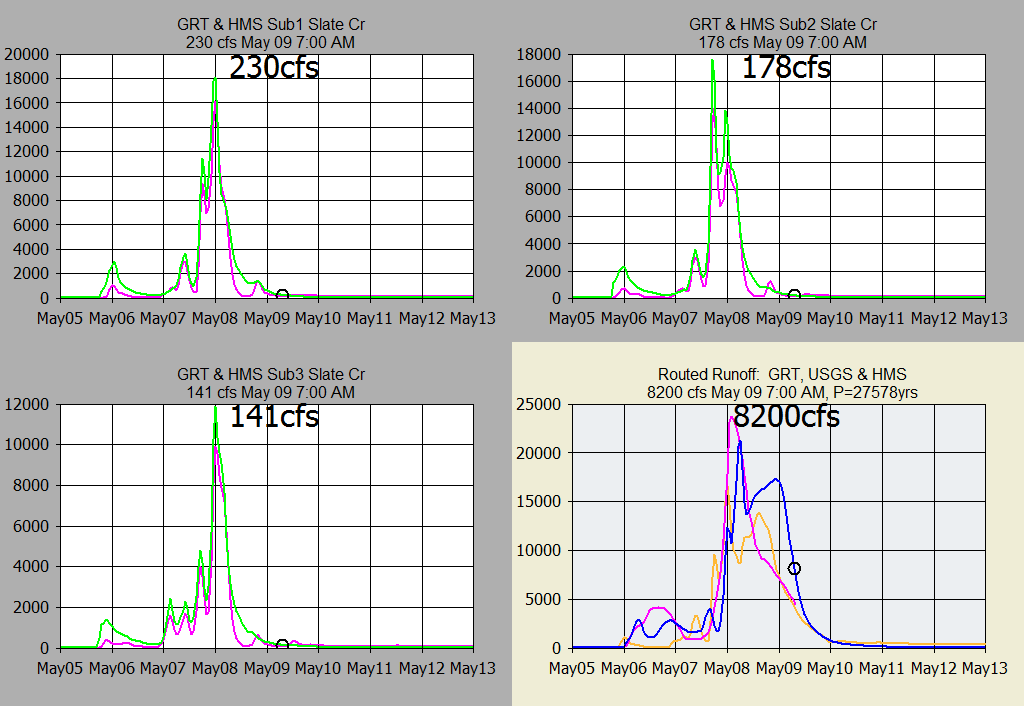
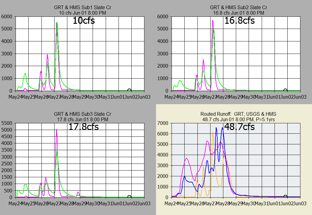
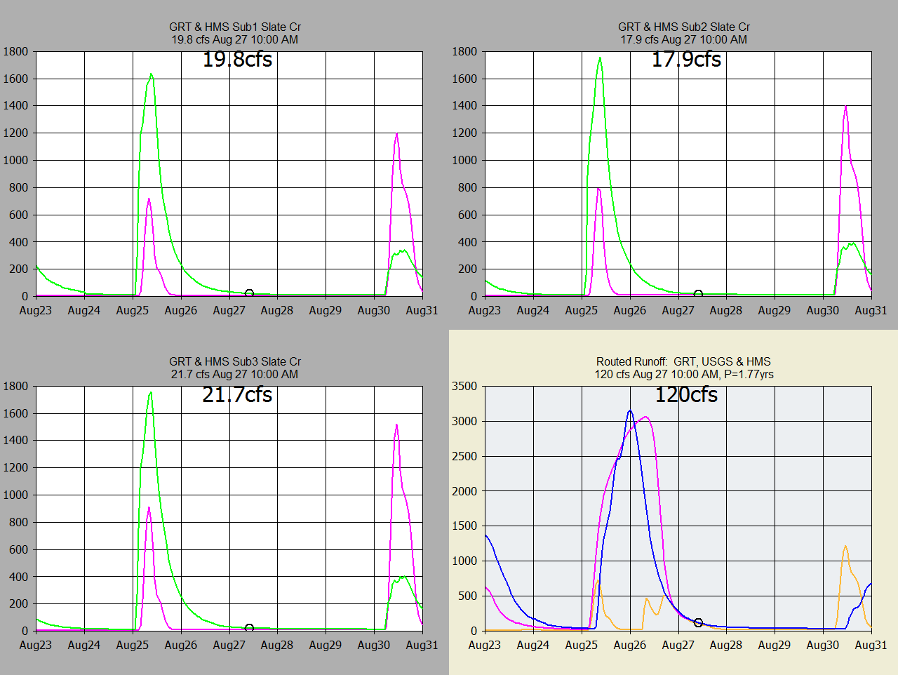
Radar A2M Snow Precip and Snowmelt Runoff with Un-heated Rain Gage Delayed
Melting:
Rainfall runoff May 24, 2022. Changed Clark unit graph to Tallapoosa dgf
with 55 CN. Needs a custom DGF from single peak event. Increased
overbank flood flow MCunge N from 0.08 to 0.12 and better matches Hec-RAS.
GetRealtime_Setup.txt Reads:
Database Connection String=Provider=Microsoft.Jet.OLEDB.4.0;Data
Source=C:\GetProjects\GetSlateCr\GetAccess\GetAccessHDB_SlateCr.mdb;User
Id=admin;Password=;
Station_ID; Datatype_Site_ID; Datatype_Name; Site_Name; base1; shift1; formula1;
base2; shift2; formula2; base3; shift3; formula3
*******; ********; *********; *** FORECASTS *****************
FORECAST-NWS; -11420; Rainfall; FORECAST Slate Cr; -2; 37.372, -97.562, 3
Run-FORECAST-NWS; -11421; Rainfall; FORECAST Sub1 Slate Cr; -2; 37.372, -97.562,
3
FORECAST-NWS; -11422; Rainfall; FORECAST Sub2 Slate Cr; -2; 37.372, -97.562, 3
FORECAST-NWS; -11423; Rainfall; FORECAST Sub3 Slate Cr; -2; 37.372, -97.562, 3
Run-FORECAST-NWS; 17433; Temperature; FORECAST C & J Property, KS; -2; 37.372,
-97.562
FORECAST-NWS; 18433; Humidity; FORECAST C & J Property, KS; -2; 37.372, -97.562
FORECAST-NWS; 28433; Wind Speed; FORECAST C & J Property, KS; -2; 37.372,
-97.562
FORECAST-NWS; 26433; Cloud Cover; FORECAST C & J Property, KS; -2; 37.372,
-97.562
***********; ********; *******:*****SNOWCAST*******; *************
SNOWCAST-NWS,KS-KM-4; 11450,23450; Melt, SWE; Kingman Co., KS 37.4111,-97.4986
Run-SNOWCAST-NWS,KS-KM-4; 17450,-17450; Air Temp, Surface Temp; Kingman Co., KS
SNOWCAST-NWS,KS-KM-4; 10450,-10450; Rainfall, Snowfall; Kingman Co., KS; 0; 0;
P1+P2
COMPUTE-Hour; 10453; Rain/melt; NWS Precip Adjust Snowcast Melt; P1=0; 0; P3;
P1>0; 0; P2
*******; ********; *********; *** RADAR *****************
A2M-ICT; -10421; Rainfall; Sub1 Slate Cr, KS; 0; Nowcast 3, adjust type 3
A2M-ICT; -10422; Rainfall; Sub2 Slate Cr, KS; 0; Nowcast 3, adjust type 3
RUN-A2M-ICT; -10423; Rainfall; Sub3 Slate Cr, KS; 0; Nowcast 3, adjust type 3
A2M-ICT; -10420; Rainfall; Full Slate Cr, KS; 0; Nowcast 3, adjust type 3
A2M-ICT; -10431; Rainfall; Wellington, KS; 0 A2M-ICT; -10432; Rainfall;
Schmeidler/burke, KS; 0
A2M-ICT; -10433; Rainfall; C & J Property, KS; 0
A2M-ICT; -10434; Rainfall; Milton, KS; 0
*******; ********; *********; *** HRRR 6Hour*****************
Run-HRR-ICT; -11422; Forecast Rain; FORECAST Sub2 Slate Cr; 0; 6
*******; ********; *********; *** Wundergages *****************
KKSWELLI10; 10431; Precip; Wellington, KS
KKSMAYFI3; 10432; Precip; Schmeidler/burke, KS
KKSMILTO3; 10434; Precip; Milton, KS
KKSMILTO3; 17433; Temperature; C & J Property, KS
KKSMILTO3; 18433; Humidity; C & J Property, KS
KKSMILTO3; 28433; Wind Speed; C & J Property,
KS KKSCONWA4; 10433; Precip; C & J Property,
KS KKSCONWA4; 29433; Solar Radiation; C & J Property, KS; 0; 0; 2.065*P1
*******; ********; *********; *** COMPUTE WEATHER *****************
COMPUTE; -29433; Solar Radiation; C & J Property, KS; 0; 37.372, -97.562,-90,
1400
COMPUTE; -29443; Long Radiation; C & J Property, KS; 0
COMPUTE; 27433; Ettall; W/solar C & J Property, KS; 0; 37.372, -97.562,-90,
1400, 1; P5
COMPUTE; -27433; ET Alfalfa; C & J Property, KS; 0; 37.372, -97.562,-90, 1400,1;
P4
*******; ********; *********; *** RATIOS *****************
COMPUTE-Hour; 10430; Rainfall; Buck Meadows Avg of 4 Rain Gages; 0; 0;
(P1+P2+P3+P4)/N
COMPUTE-Hour; -10430; Rainfall; Buck Meadows Avg of 4 Radars; 0; 0;
(P1+P2+P3+P4)/N
Run-COMPUTE-Hour; 31427; Ratio; Buck Meadows, Ca Gage/dax; 0; .02, 1, 4; P1/P2
*******; ********; *********; *** ADJ RADAR *****************
COMPUTE-5unit; -11420; Rainfall; Slate Cr Basin Adjusted DAX Radar; 0; -1,
1,0.25, 0.80; P1*P2
COMPUTE-5unit; -11421; Rainfall; Sub1 Slate Cr, KS Adjusted DAX Radar; 0; -1,
1,0.25, 0.80; P1*P2
COMPUTE-5unit; -11422; Rainfall; Sub2 Slate Cr, KS Adjusted DAX Radar; 0; -1,
1,0.25, 0.80; P1*P2
Run-COMPUTE-5unit; -11423; Rainfall; Sub3 Slate Cr, KS Adjusted DAX Radar; 0;
-1, 1,0.25, 0.80; P1*P2
*******; ********; *********; *** Basin Snowmelt *****************
SNOWMELT-Unit; 11420,-23420; Melt, SWC; Slate Cr Snowmelt; 0; 0, 1, 1.15, 1, 1,
1, 1, 32
SNOWMELT-Unit; 11421,-23421; Melt, SWC; Sub1 Slate Cr, KS Snowmelt; 0; 0, 1,
1.15, 1, 1, 1, 1, 32
SNOWMELT-Unit; 11422,-23422; Melt, SWC; Sub2 Slate Cr, KS Snowmelt; 0; 0, 1,
1.15, 1, 1, 1, 1, 32
SNOWMELT-Unit; 11423,-23423; Melt, SWC; Sub3 Slate Cr, KS Snowmelt; 0; 0, 1,
1.15, 1, 1, 1, 1, 32
*******; ********; *********; *** Point Snowmelt *****************
COMPUTE-Hour; 11451; Rain/melt; Adjust NWS Melt Kingman Co., KS; P1=0; 0; P3;
P1>0; 0; P2
SNOWMELT-hour; 11453,-23453; Melt, SWC; GRT at NWS Model Point; 0; 0, 1, 1.15,
1, 1, 1, 1, 32
*******; ********; *********; *** Runoff *****************
COMPUTE-5unit; -30420; RUNOFF; Big Cr nr Groveland, Ca Adjmeltn0q; 0; 5, 65,
0.10, 2, 154, 0.4, 0.17, 0.5, 1.5, 0.2, 3.0, 92, 64, 0.95, .2, 1, 0.3, 0.8,
0.03, 1, 0, 0.2, 1, 1, -1, LagV; P1; 0; GreatPlains.DGF
COMPUTE-5unit; -30421; RUNOFF; Sub1 Slate Cr; 0; 9, 70, 0.10, 0, 44.0, 1.67,
0.3, 0, 2.5, 0, 6.0, 94, 69, 0.95, 0.25, 4, 0.3, 0.8, 0.03, 1.0, 0, 0.2, 0, 1,
0, LagV; P1; 0; VillageCreek.DGF
COMPUTE-5unit; -30422; RUNOFF; Sub2 Slate Cr; 0; 9, 70, 0.10, 0, 54.0, 1.67,
0.3, 0, 4, 0, 6.0, 94, 69, 0.95, .25, 4, 0.3, 0.8, 0.03, 1.0, 0, 0.2, 0, 1, 0,
LagV; P1; 0; GreatPlains.DGF
COMPUTE-5unit; -30423; RUNOFF; Sub3 Slate Cr; 10; 9, 70, 0.10, 0, 55.8, 1.67,
0.3, 0, 2.5, 0, 6.0, 94, 69, 0.95, 0.25, 4, 0.3, 0.8, 0.03, 1.0, 0, 0.2, 0, 1,
0, LagV; P1; 0; GreatPlains.DGF
Run-Route; -1419; FLOW; Subs 1,2,3; 4 Lookup; -2419; Stage; Slate Creek at
Wellington, KS
COMPUTE-hour; -6420; Future Runoff Fraction; Basin Future Fraction Runoff; 0; 0;
0; P2>0.2*P1; 0; 100*(P2-0.2*P1)^2/(P2+0.8*P1)/P2
COMPUTE-hour; -5420; SCS CN; Full Slate Cr Basin; 0; 0; 1000/(P1+10)
*******; ********; *********; ***USGS FLOW STAGE*****************
07145700; 1419; Flow; SLATE C AT WELLINGTON, KS
07145700; 2419; Stage; SLATE C AT WELLINGTON, KS
*******; ********; *********; ***HEC-HMS PROJECT*****************
COMPUTE-Put-unit; 11421; PRECIP-INC; Sub1 Slate Cr, KS; 0;
C:\GetProjects\GetSlateCr\HMSProject\NashvilleBasinRainfall.dss
COMPUTE-Put-unit; 11422; PRECIP-INC; Sub2 Slate Cr, KS; 0;
C:\GetProjects\GetSlateCr\HMSProject\NashvilleBasinRainfall.dss
COMPUTE-Put-unit; 11423; PRECIP-INC; Sub3 Slate Cr, KS; 0;
C:\GetProjects\GetSlateCr\HMSProject\NashvilleBasinRainfall.dsss
SHELL-C:\Program Files\HEC\HEC-HMS\4.5\HEC-HMs.cmd; -1; Flow; Slate Cr HMS; 0;
C:\GetProjects\GetSlateCr\HMSProject\Project_2.hms, Control_1.control, Run 1,
5-Minute; delete.log
*******; ********; *********; ***GET HEC-HMS OUTPUT*****************
COMPUTE-get; -1521; Runoff; HMS Sub1 Slate Cr
COMPUTE-get; -1522; Runoff; HMS Sub2 Slate Cr
COMPUTE-get; -1523; Runoff; HMS Sub3 Slate Cr
COMPUTE-get; -1519; Runoff; HMS Basin Outflow
Lookup; -2519; Stage; HMS Slate Creek at Wellington, KS
*******; ********; *********; ***SEND TO WEB PAGE*****************
SHELL-C:\GetProjects\GetSlateCr\GetGraphs\GetFromAccessNOW.exe rdaymax, 10430
-10430 -11420 -10420 -23420 -1519 -1419 1419, -2, 5, SlateCreekNOW.txt,
mypassword; 0; Flow Data to Web; Put Flow Data Text File on Web; 0
SHELL-C:\GetProjects\GetSlateCr\GetNexrad\GetNexrad.exe -2 mypassword; 0;
Picture; Slate Creek Nexrad Picture; 0
SHELL-C:\GetProjects\GetSlateCr\GetGraphs\GetGraphs.exe 4 mypassword; 0; Graphs;
Getgraphs to Web; 0 END
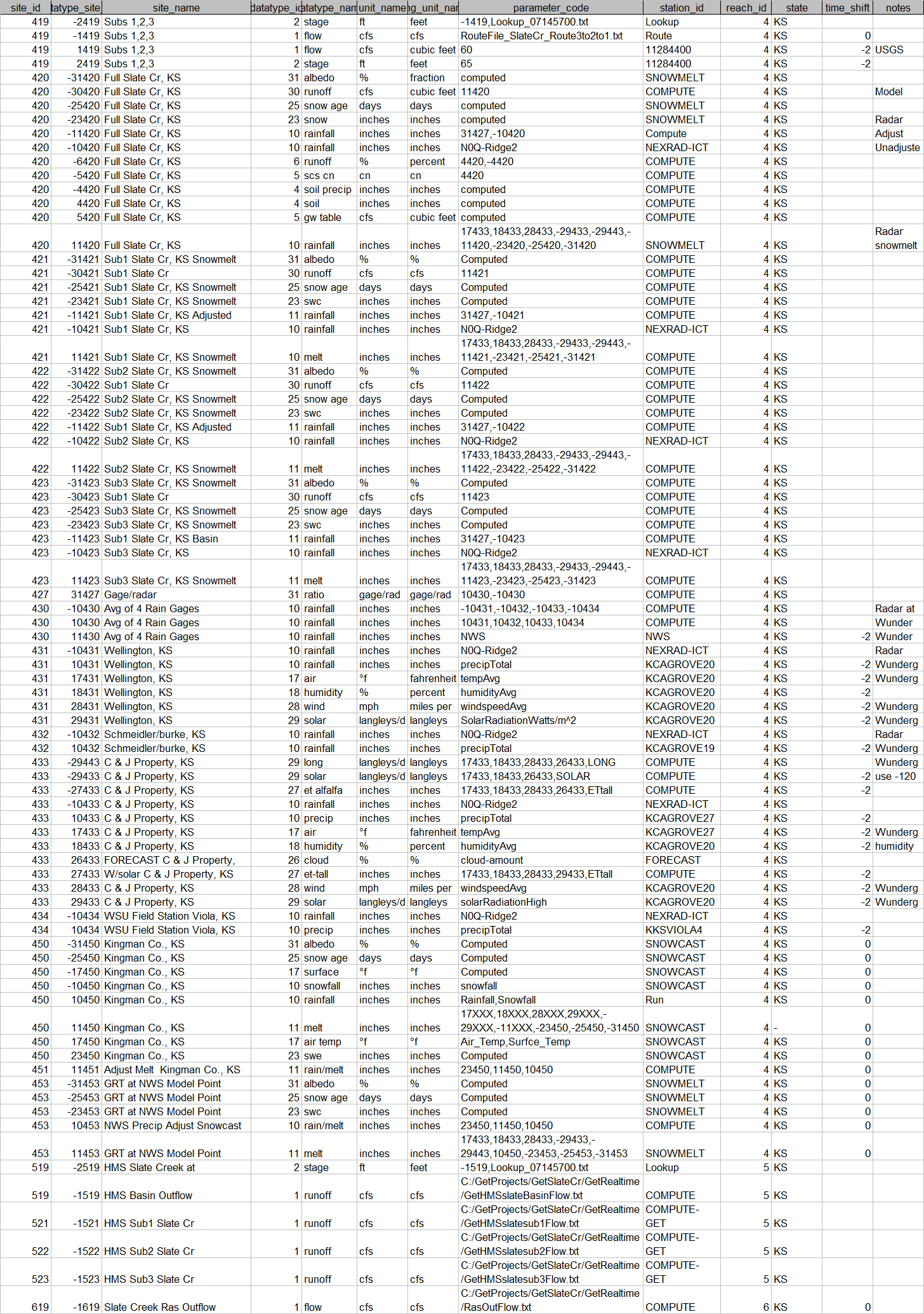
Access table rsite:
Important Note: Nothing on this page is intended as
interpretation of any legal authority such as water rights and supply. This page
is intended solely as a demonstration of techniques in flood potential
monitoring. The reader assumes all risk for any damages whatsoever in connection
with the access, use, quality, or performance of the supplied data just so you
know.
|