Just getting going with NO calibration.
Improvements will be made as realtime radar comes in.
Emigrant Dam was selected to
imrpove simple Modpul reservoir operations.
The system plumbing was important here so snowmelt and calibrations can wait.
Update Oct 2016: With 3-4 inchs of rain/snow in Oct
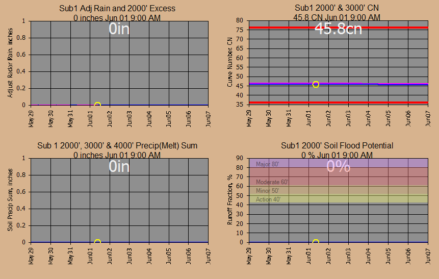
the soil Curve Numbers and interception factors have been updated.
I'm now thinking how an irrigation district could have its whole system operated
top to bottom... ET crop use, water orders, rainfall, water order cuts,.. the
whole enchillada.
The plumbing is now ready so let's get going FOR FREE.
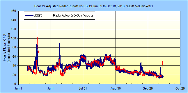
The plumbing... Note USGS Bear Cr gage just below Talent
Canal diversion as study end point. This area turned out to be a very
interesting scheduling and routing example so with my free GetRealtime
updated even Grand Coulee is on the menu now without shelling a Hec-RESSIM
reservoir model and thats a load off!
The
168 sqmi basin above the USGS streamgage 14354200 BEAR CREEK BLW ASHLAND CREEK
AT ASHLAND, OR (gage datum 1,686.64 ft) was
subdivided into 13 subbasins using my free GetMapArea. The
subbasins are shown on my free GetNexrad display below.
Snowmelt elevation bands will probably be needed but for now I want to see how
far I can get with out more subdividing. Update: Now that Google Earth Pro
is free I have found using it for boundary lat/longs and elevation band areas to
be VERY helpful. The saved KML polygon lat/longs can be converted to boundaries
using my
GoogleKML2Text.exe.
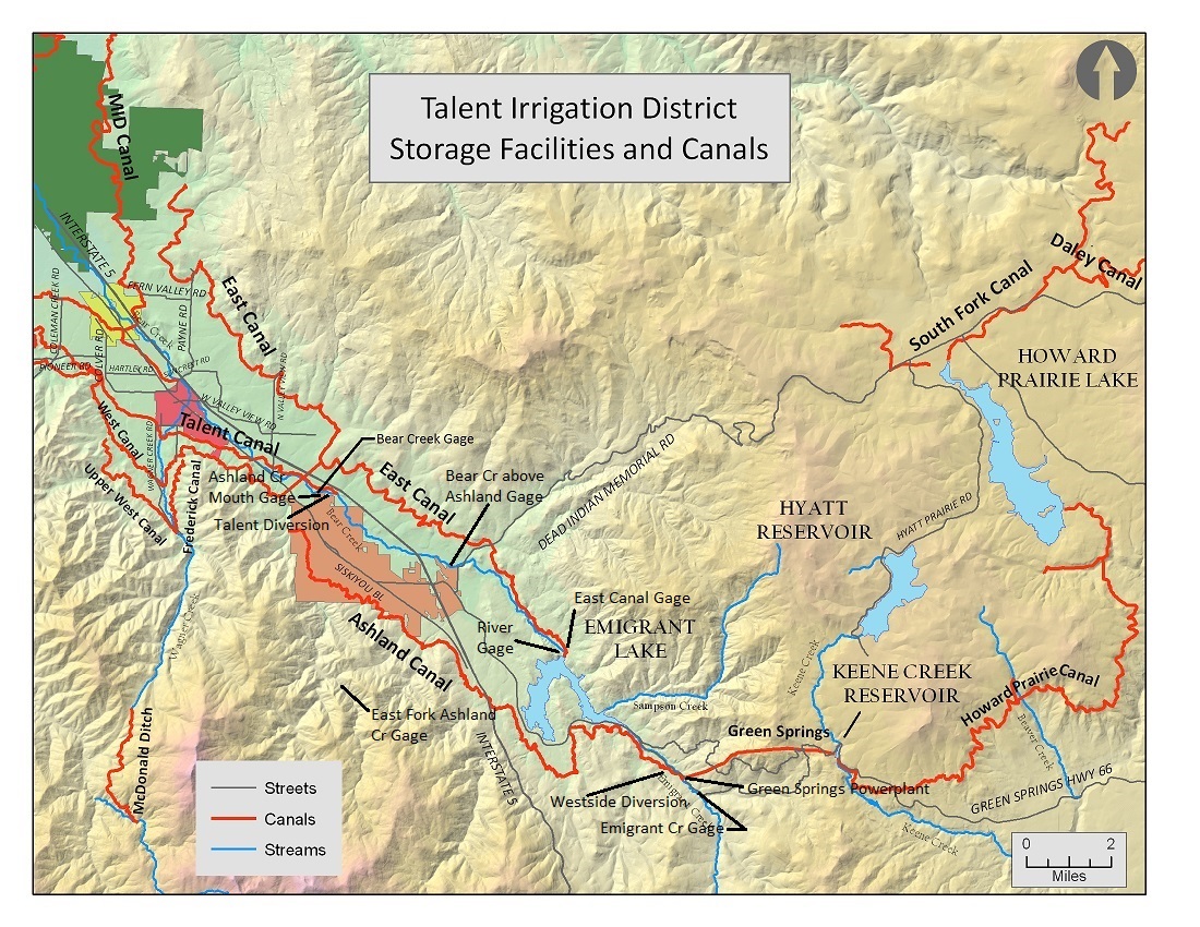
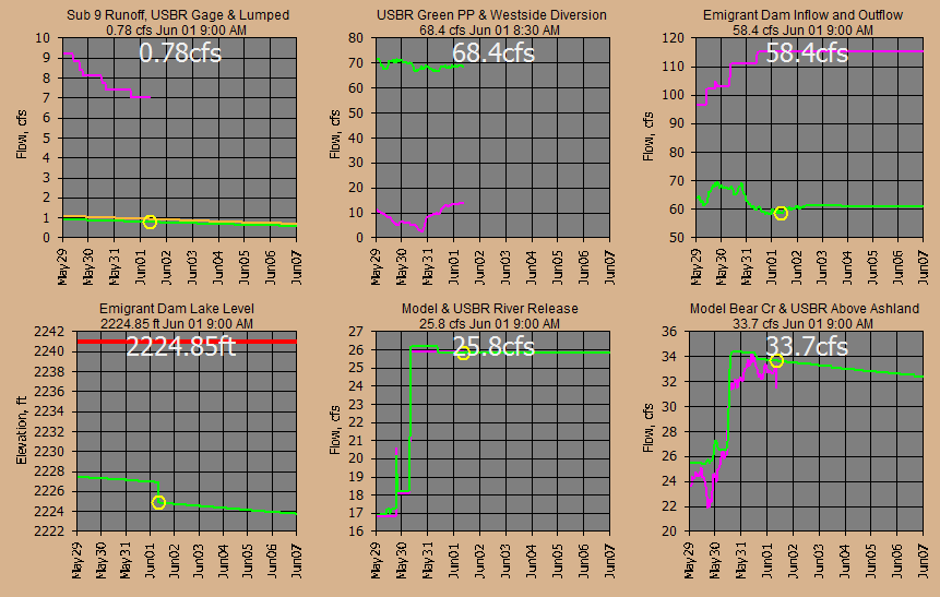
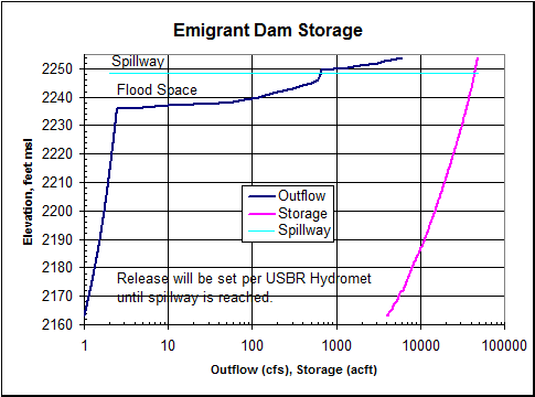
Emigrant Dam
has a 39,000 acre-foot reservoir operated by the
Talent Irrigation District. The USBR Hydromet
data system provides near real-time releases and forebay elevation. My
runoff model uses the latest release and operates the reservoir with model
forecast of runoff. I doubt the spillway has ever been used from the looks
of the brave souls building right on the river below the dam but you just never
know about rain on snow. Releases are limited to the 670 cfs river channel
capacity and exclusive flood space target elevation is 2241 ft for joint use
conservation. Flood stages at Ashland will most very likely be local
runoff and runoff below the dam... unless you patiently watch here... for
decades... or tomorrow.
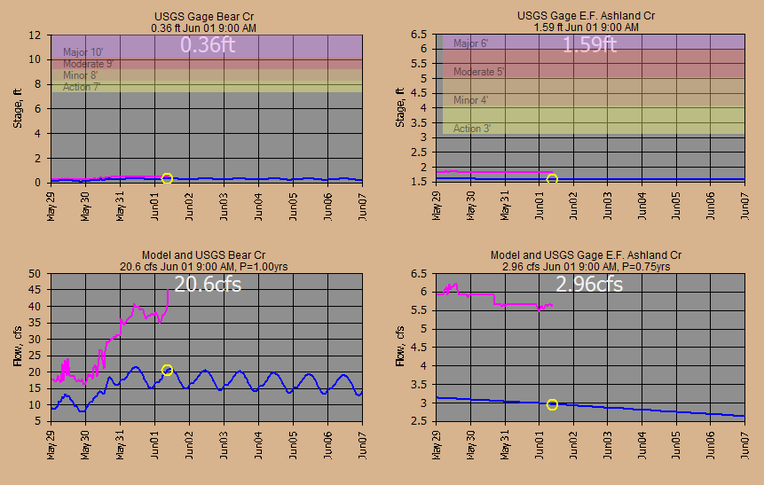
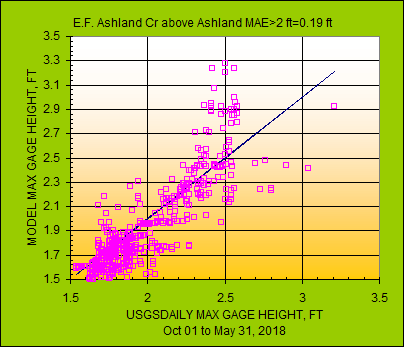
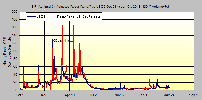
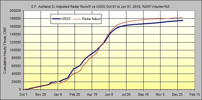
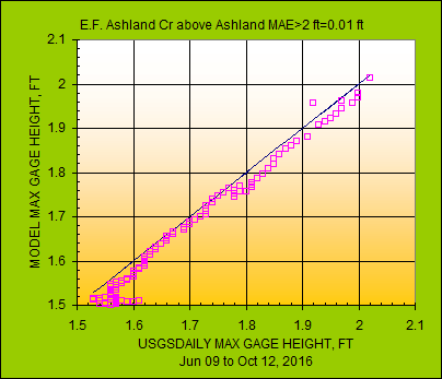
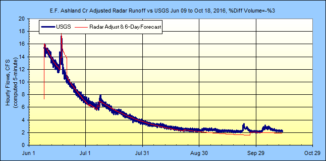
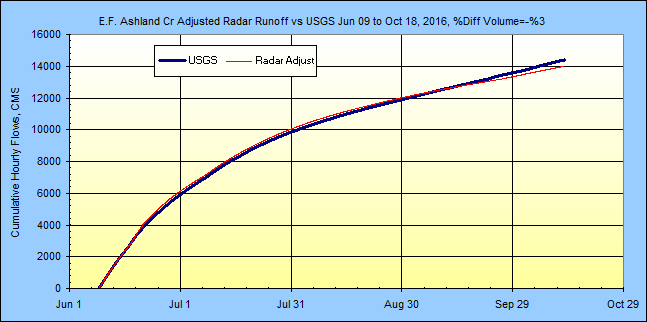
The 8.14 sqmi basin for USGS streamgage 14353500 EAST FORK ASHLAND CREEK NEAR
ASHLAND, OR (gage datum 2,903.70 ft) has not been subdivided and should prove
helpfull in calibrating forested subbasins... which means very little runoff
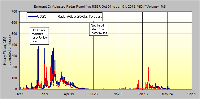
from the looks of the annual peaks. I have also added a snowpack to Subs 2
and 3 on upper Ashland Creek on June 1 to match the flows at the gage, but the
swc is a guess and the snowpack lastet only 3 days anyway so I added 1.75 inches
to soil moisture on Jun 9 to match the East Fork Ashland Creek gage flow.
The channel routings were cascading Modified Puls ratings using my free
ModPulXsec with x-section data measured with Google Earth about midway
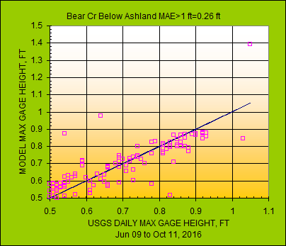
in each reach. The bank full elevation is the flood 'Action Stage' at my
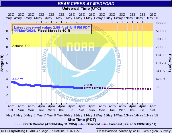
ratings and the USGS gage rating. The NWS operates a
forecast flood site at the next downstream gage on Bear Creek
above Medford, OR.
Normally I run some history to calibrate the soils, but in this case I'm more
interested in operating a Modpul rating for Emigrant Dam so I'll get the soils
caught up eventually. You could shell a Hec ResSim model but a quick
Modpul should be sufficient here once I get the fleas out of my scheduled
hourly
RELEASE for a MODPUL and ADD command for release, inflow, and diversions. All flows, snowmelt,
and runoffs are 5-minute values to match radar rainfall needed on small basins.
Let's see how we do in real-time
(all times are my Pacific Time).
This web page is automatically updated hourly as my free GetRealime
runs in unattended batch mode on a low powered Windows 10 laptop... when rain/snow is in the area.
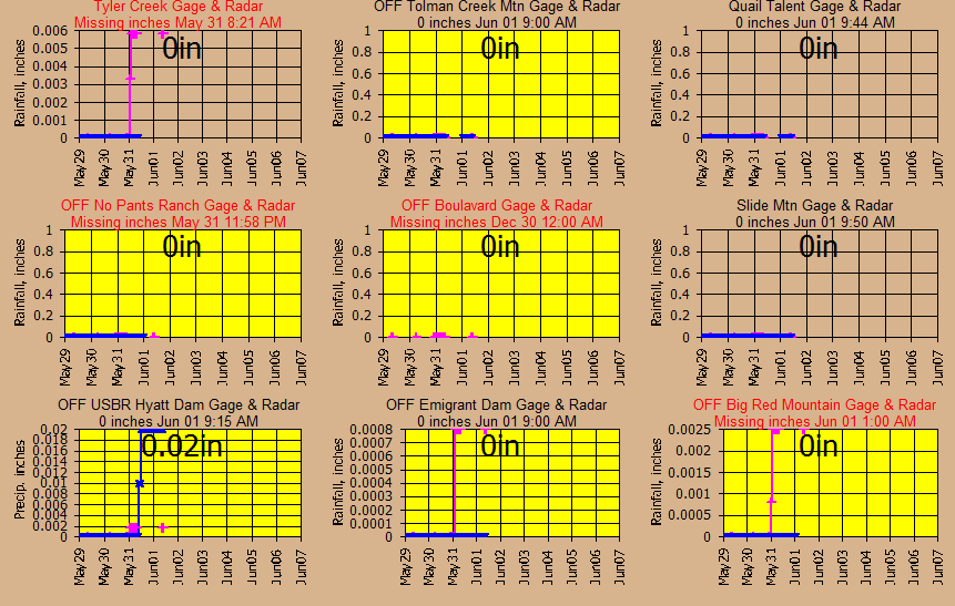
Real-time radar image monitoring by my shelled free GetNexrad:
(Today's
+ Yesterday's Rainfall. Radar cells are 0.6
miles wide. Note the cone of silence at the radar at the top of s103.
Subs 108, 109, and 110 flow into Emigrant Dam. Also note I screwed up
scale setting digitizing subs 7-10 per ugly gap. )
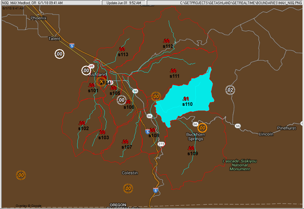
Probably not so much here where it hardly rains during the irrigation season,
but an irrigation district could use the areas of rainfall above to know how to
cut water orders and areas of runoff affecting water quality. And in rough
years what areas have been the driest for season startup.
Intellicast big picture Current Approaching Radar Loop:

Current real-time monitoring graphs with my free GetGraphs:
If you need data from the database sent to your web page sort of like this data table,
then GetRealtime can shell my free GetFromAccessNow or write
your own SQL and shell it:
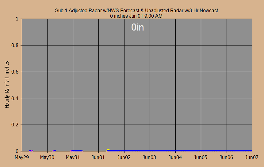
NWS forecast and 3-Hour Nowcast:
Alert triangles for forecasts greater than 0.1 inch/hour.
(All graphs pink colored series is the second source referred to so the pink
here is raw radar w/nowcast)
(The
Nowcasts will be evaluated on my
web page here.)
Flood Stage at Main Street Downtown Ashland :
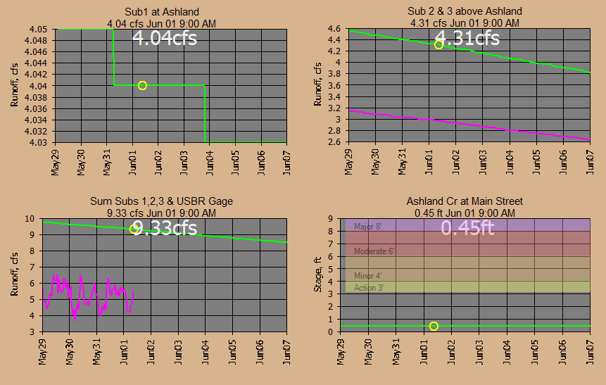
Flood Stage USGS Gages Bear Cr below Ashland and Sub 3 East Fork Ashland
Cr:
========================================================
More Current Info...........
========================================================
Raw Radar at the Wundergages:
Hourly Gage/Radar Ratio Adjustments:
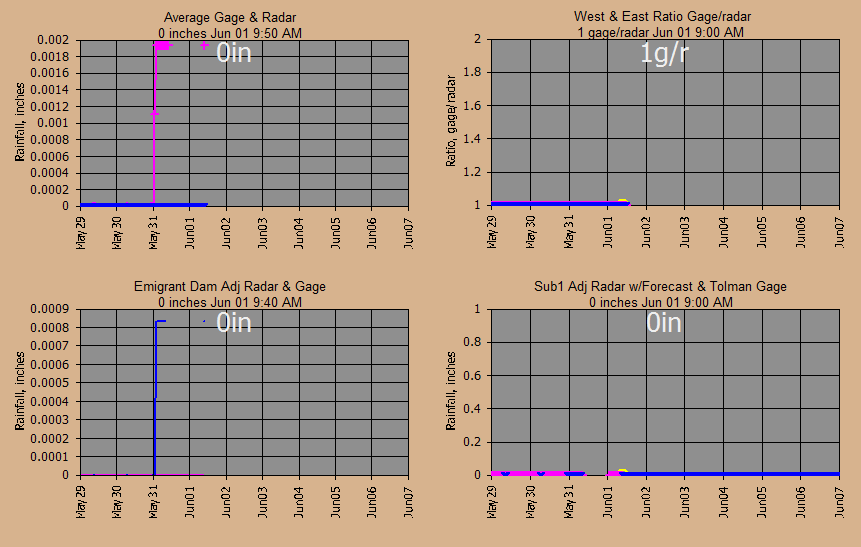
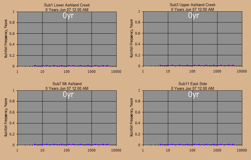
Rainfall Frequencies and Depths:
Soil Moisture:
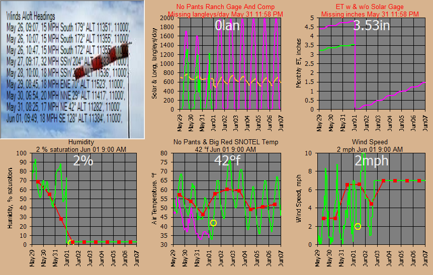
Weather:
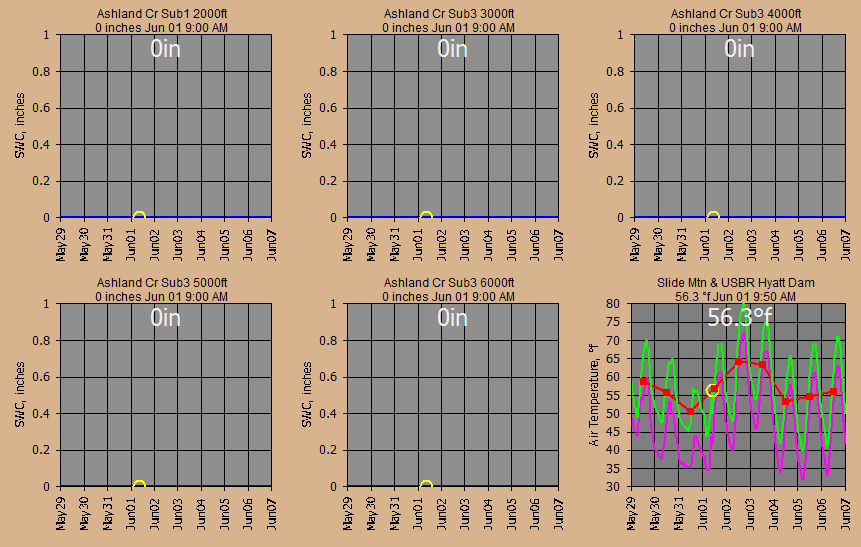
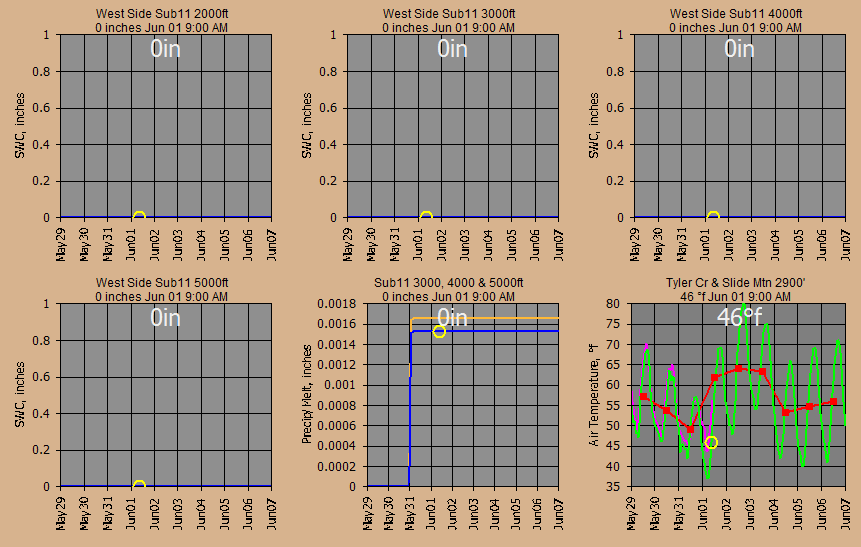
Snowpacks (snowmelt computations are based on 1000 ft elev bands for the
13 subbasins):
Snowpacks (snowmelt computations are based on 1000 ft elev bands for the
13 subbasins):
Modpul
operations Emigrant Dam with hourly release setting (until spillway):
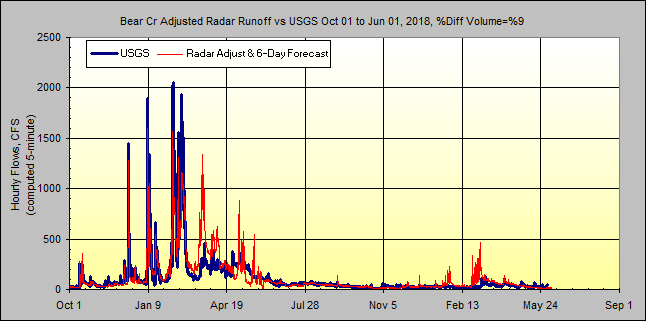
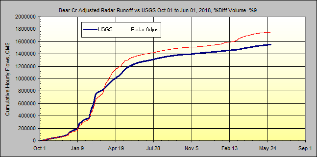
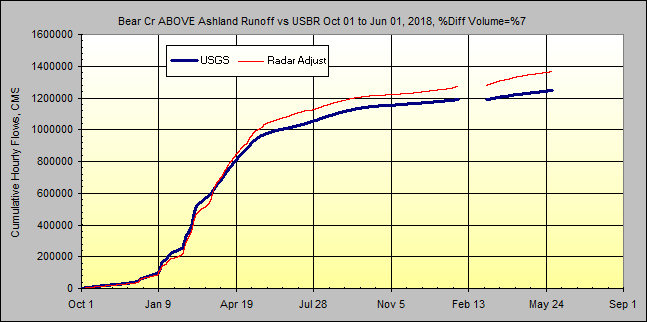
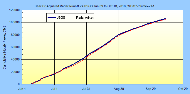
Review of all the Bear Creek flows:
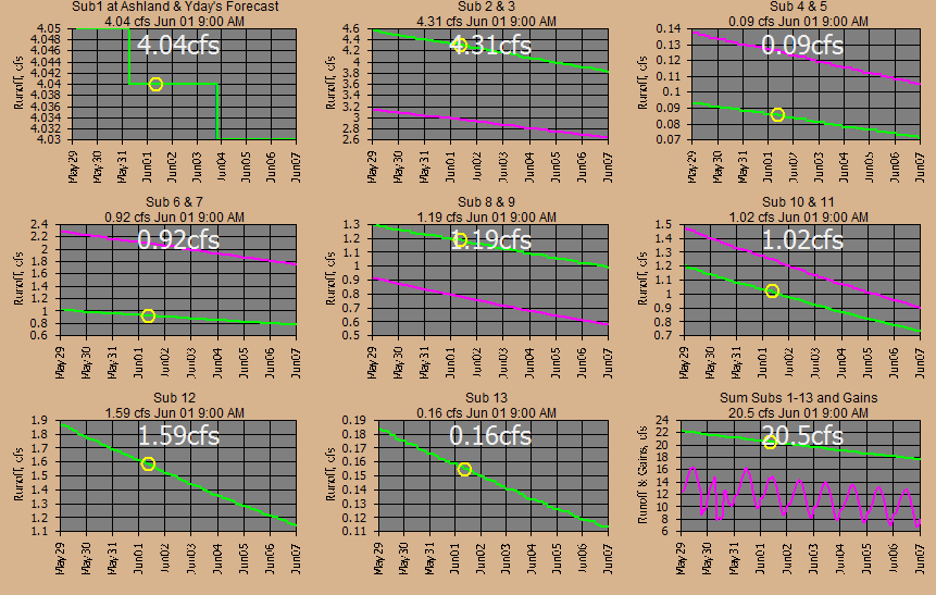
Flows at each of the 13 subbasins:
Now at this point as an example, any irrigation district could replace the need
for the USBR data used here by replacing the schedules and history in the
database themselves.
More info:
http://www.usbr.gov/projects/Facility.jsp?fac_Name=Emigrant+Dam&groupName=Overview
http://www.talentid.org/
Long Term Info
Begin Jun 1, 2016 with No Calibrations:
Jun 1, 2016: Using Napa Valley, California soil setups and unit graph.
Interesting that so far the recession slopes match Napa. Lag times are
from my free GetMapArea slope roughness stream/centroid USBR
method and so far no complaints.
Jun 17, 2016: Constructed dimensionless unit graph for East Fork Ashland Creek
USGS gage and using at Sub2 and Sub3 for forested areas. Added 1.75 inches
to June 9 soil moisture Subs 2 and 3 to match USGS gage. Added 6 cfs
diurnal fluctuation to Bear Creak routing above Ashland based on USGS gage
flucuations to make things pretty at the gage.
Getting some rain to work with.....
Jun 18, 2016: Raised percent impervious for
urban areas on subs 1, 4, and 5. Adjusted losses in Bear Creek at Sub 12
and Ashland Creek at Mouth. Who knows where a constant 50 cfs loss goes.
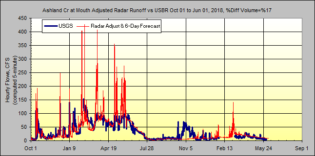
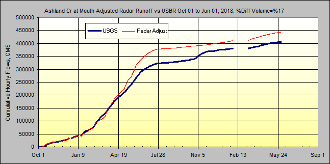
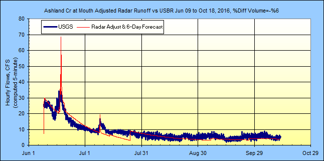
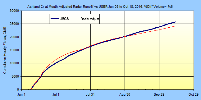
Jun 19, 2016: Found USBR gages on Ashland Cr at Mouth and Emigrant Creek
(Sub 9). Left Ashland Cr Sub 1 alone. Raised Sub 9 percent
impervious from 0 to 0.6%, raised interception factor from 0.03 to 0.07 and
removed GW return with factor from 0 to 1. Added USBR Green Springs
Powerplant transbasin inflow to Emigrant Dam inflows.
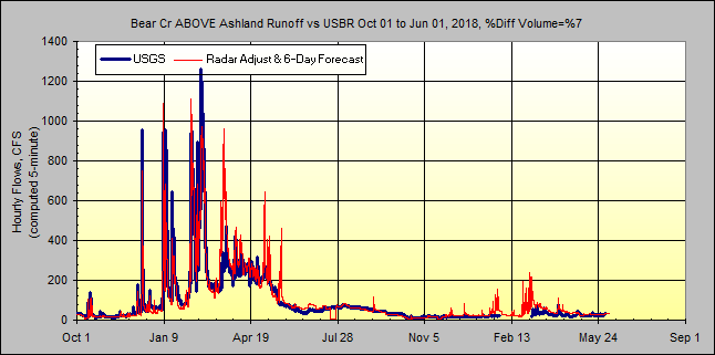
Jun 22, 2016: Found USBR gage Westside Diversion Canal and removed from
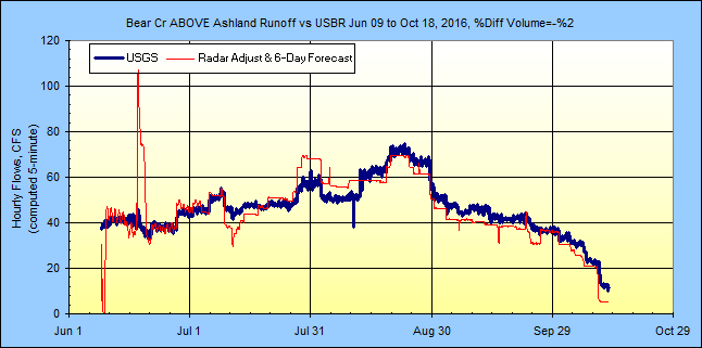
Emigrant Dam inflow. Found USBR gage Bear Creek ABOVE Ashland and added
for river routing comparison at Sub 12. Found USBR Talent Canal diversion
gage just above USGS Bear Creek gage and added to routing. So that's where
some of the water was disappearing to. I believe the system plumbing is
correct and should now be complete. Fudge factors for diversion/runoff
error are used in the routings at 3 points, Bear Cr ABOVE Ashland (-5 cfs) and
Ashland Cr at Mouth (-8 cfs), and Bear Cr BELOW Ashland (+5 cfs).
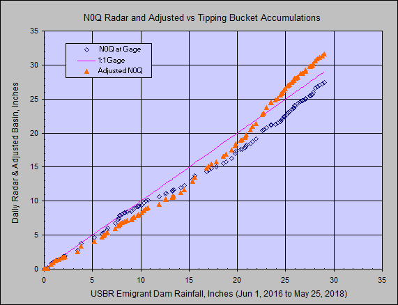
Radar RainFall Adjustments, Hourly and Daily:
(Update Oct 18, 2016: looks like next step is to use different Wundergages
for distance from radar or orographics... this is very poor hourly.)
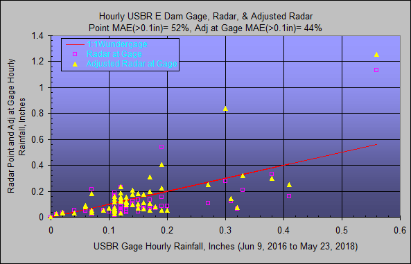
The Dailys always line up, it's the hourlys that count!!!
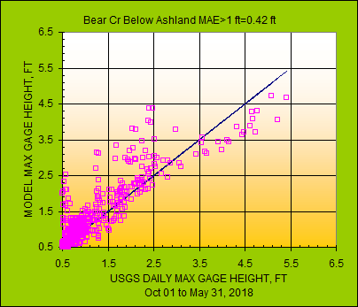
Model vs Gaged Flows Oct 1, 2016 to... :
Model vs Gaged Flows Start Up:
USGS flows used for dimensionless unit graph at East Fork Ashland Creek gage
(yes that's a very large peak flow indeed, is it not!):
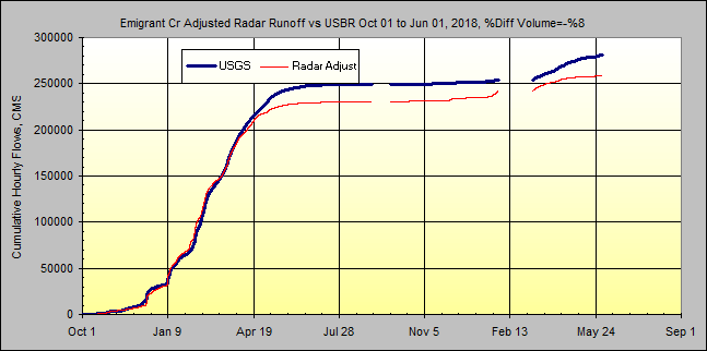
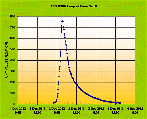
USBR flows used for dimensionless unit graph at Emigrant Creek gage:
Emigrant Dam Storage taken from USBR Hydromet 15-minute values over
2016 six month
filling period. USBR limits releases to 670 cfs river channel capacity.
Model releases set per USBR Hydromet hour 1 each day.
Initial 5-minute Routings for 13 subs before snowmelt banding:
Bear Creek to USGS gage:
1) Green Springs Powerplant inflow (Hydromet).
2) Add Sub 9 runoff.
3) Divert Westside canal (Hydromet).
4) Add Subs 8+10 runoff.
5) Total inflow Emigrant Dam
6) Emigrant Dam total release.
7) Divert Eastside Canal (Hydromet).
8) River release.
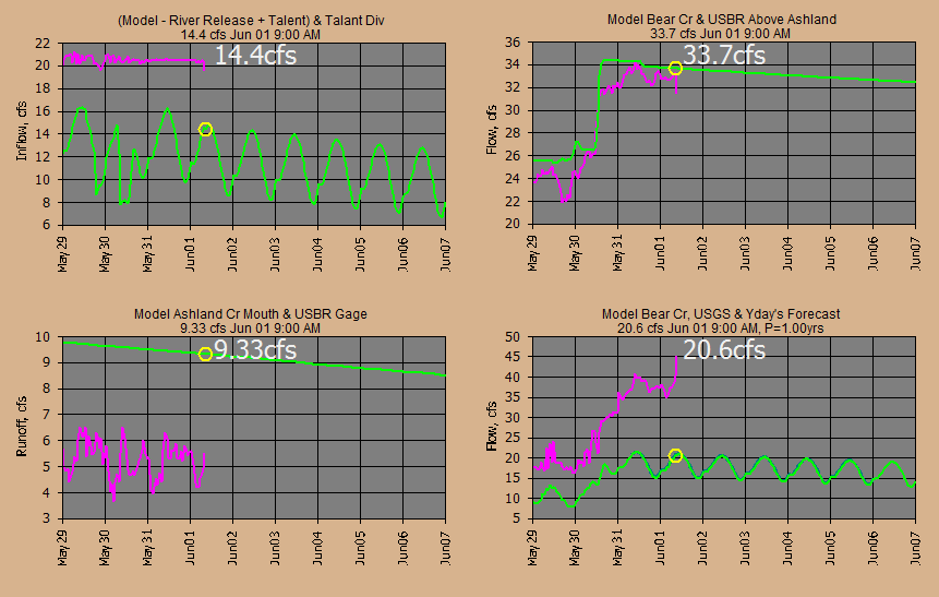
9) Route river release to Sub 12.
10) Route Sub 7 runoff to Sub 12.
11) Combine routed river and routed 7 with runoff Subs
4+5+6+11+12+13-fudge_factor
12) Total river flow ABOVE Ashland USBR gage.
13) Route total river above Ashland to USGS gage below Ashland
14) Divert Talent canal (Hydromet).
Ashland Creek to Mouth USBR Gage:
1) Combine Subs 2+3 runoff East Fork Ashland Cr and route to USBR gage
Mouth
2) Combine Sub 1-fudge_factor at USBR Mouth gage.
Combine Ashland Cr and Bear Cr:
1) Combine Ashland Mouth+routed Bear Cr+fudge_factor at USGS gage for total flow.
END
Now export 10 days of daily values from the database to Excel for each point
above BEFORE routing and manually verify total.... Whooooohoooo!!!!
USGS Bear Creek Blw Ashland
Gage Annual Peak Flow Log-Normal Probability Distribution from my free
GetRegression:
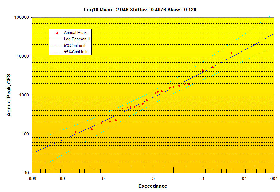
Log Pearson
USGS 14353500 EAST FORK ASHLAND CREEK NEAR ASHLAND, OR:
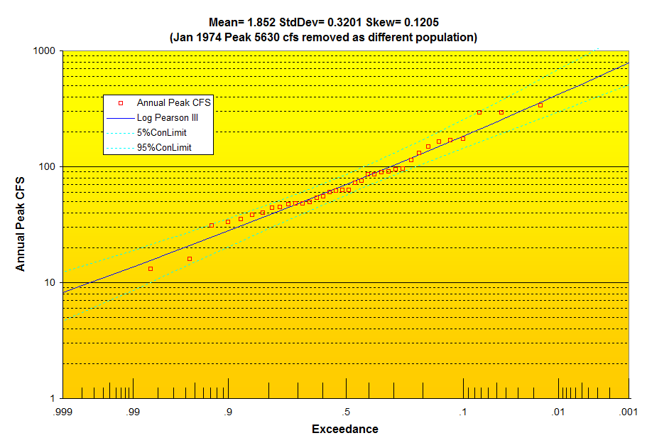
Top 10 annual peaks are winter rains I'm guessing. It sometimes happens
with a sudden warm up from a cold snow covered basin that it all can come down
at once from all elevations. Toss in some rain and Kaboom!!!!
Date Annual Peak CFS
1/15/1974 5630 Kapow!!!
12/2/1962 335
2/20/1927 292
12/21/1955 292
12/19/1981 174
12/30/2005 168
12/2/2012 164
2/24/1958 149
10/31/1924 130
2/17/2004 114
3/26/1928 96
6/1/1975 94
The 6-hour NWS forecasts are distributed to 5-minutes using my Vegas 3
distribution and thought that would fit in around here and Nowcasts based on
winds aloft are limited to 3 hours.
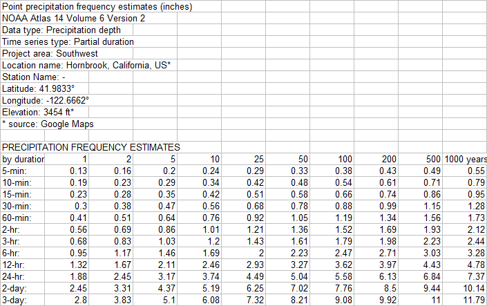
NOAA Atlas 14 used in frequency graphs above just over the California border:
"Surface temperature lapse rates over complex terrain: Lessons from the Cascade
Mountains"
Justin R. Minder 2009
Monthly Lapse Rates Cascade Mountains (usually 6.5°C km−1)
Leeward Windward
Oct 5.9 4.9
Nov 6.5 6.1
Dec 3.3 5.3
Jan 2.2 4.5
Feb 5.7 6.3
Mar 7.7 5.8
Apr 7.8 6.5
May 7.7 4.7
Jun 8.0 5.2
Jul 7.8 4.0
Aug 7.6 4.8
Sep 7.3 5.2
GetRealtime_Setup.txt:
Future Days=6
Percent Missing Allowed= 100%
Write Dailys= True
Write Hourly Avg=
True
Write Daily Max= True
Write Unit Values= True
Write Unit Shifts= False
Overwrite Protected Source 5= True
Check for Possible Bad Values= False
Possible
Bad Value Change= 150%
Last Runoff Run's Storage= True
Minutes between
retrievals=60
Max hours of radar=4
Save Radar greater than= False
Beep on Save=
True
Delete temporary internet files=True
Loop radar boundaries=True
Use Nexrad
Ridge1 full web file listing=False
Use Nexrad short web file listing=False
Use
Nexrad Ridge2 Iowa State Mesonet=True
Compact and Backup HDB at midnight= True
GetAccess.exe folder=C:\GETPROJECTS\GETASHLAND\GETACCESS\
GetGraphs.exe
folder=C:\GETPROJECTS\GETASHLAND\GETGRAPHS\
GetNexrad.exe
folder=C:\GETPROJECTS\GETASHLAND\GETNEXRAD\
NowCast Info
folder=C:\GETPROJECTS\GETASHLAND\GETNEXRAD\
Gage Avg OnOff
folder=C:\GETPROJECTS\GETASHLAND\GETGRAPHS\
Radar Boundary File
folder=C:\GETPROJECTS\GETASHLAND\GETREALTIME\BOUNDARIES\
Menu
Pic=C:\GETPROJECTS\GETASHLAND\GETREALTIME\ASHLANDVIEW.JPG
Menu Text Color= 0
Minimize to System Tray=True
Column Widths=1710,1230,2130,5385,555,2505,2205
Alert Address=
Alert Address CC=
Alert Address BCC=
Don't Ask Questions=True
Create Winds Aloft graphic file=True
Metric Units=False
Database Connection
String=Provider=Microsoft.Jet.OLEDB.4.0;Data
Source=C:\GetProjects\GetAshland\GetAccess\GetAccessHDB_Ashland.mdb;User
Id=admin;Password=;
Station_ID; Datatype_Site_ID; Datatype_Name; Site_Name;
base1; shift1; formula1; base2; shift2; formula2; base3; shift3; formula3
************; ************; ************; *****MAX RADAR*******
NEXRAD-MAX;
-10101; Radar Rain; Sub1 Ashland Creek; 1; Nowcast 2
NEXRAD-MAX; -10102; Radar
Rain; Sub2 Ashland Creek; 1; Nowcast 2
NEXRAD-MAX; -10103; Radar Rain; Sub3
Ashland Creek; 1; Nowcast 2
NEXRAD-MAX; -10104; Radar Rain; Sub4 Bear Creek; 1;
Nowcast 2
NEXRAD-MAX; -10105; Radar Rain; Sub5 Bear Creek; 1; Nowcast 2
NEXRAD-MAX; -10106; Radar Rain; Sub6 Bear Creek; 1; Nowcast 2
NEXRAD-MAX;
-10107; Radar Rain; Sub7 Bear Creek; 1; Nowcast 2
NEXRAD-MAX; -10108; Radar
Rain; Sub8 Bear Creek; 1; Nowcast 2
NEXRAD-MAX; -10109; Radar Rain; Sub9 Bear
Creek; 1; Nowcast 2
NEXRAD-MAX; -10110; Radar Rain; Sub10 Bear Creek; 1; Nowcast
2
NEXRAD-MAX; -10111; Radar Rain; Sub11 Bear Creek; 1; Nowcast 2
NEXRAD-MAX;
-10112; Radar Rain; Sub12 Bear Creek; 1; Nowcast 2
NEXRAD-MAX; -10113; Radar
Rain; Sub13 Bear Creek; 1; Nowcast 2
NEXRAD-MAX; -10131; Radar Rain; KORASHLA8
East Ashland Hills; 1
NEXRAD-MAX; -10132; Radar Rain; KORASHLA25 Tolman Creek
Mountain Ashland; 1
NEXRAD-MAX; -10133; Radar Rain; KORTALEN1 Quail Run Talent,
OR; 1
NEXRAD-MAX; -10134; Radar Rain; KORASHLA43 No Pants Ranch Ashland; 1
NEXRAD-MAX; -10135; Radar Rain; KORASHLA10 Ashland; 1
NEXRAD-MAX; -10136; Radar
Rain; KORASHLA44 Knowles; 1
NEXRAD-MAX; -10138; Radar Rain; Big Red Mountain
SNOTEL; 1
NEXRAD-MAX; -10401; Radar Rain; USBR Emigrant Dam, OR; 1
NEXRAD-MAX;
-10404; Radar Rain; USBR Hyatt Dam, OR; 1
************; ************; ************; *****NWS Forecasts*****
FORECAST-NWS; -11101; Forcast Rain>0.1"-hour; Sub1 Ashland Creek; 0; 42.031, -122.655, 3
FORECAST-NWS; -11102; Forcast Rain; Sub2 Ashland Creek; 0; 42.031, -122.655, 3
FORECAST-NWS; -11103; Forcast Rain; Sub 3 Ashland Creek; 0; 42.031, -122.655, 3
FORECAST-NWS; -11104; Forcast Rain; Sub 4 Bear Creek; 0; 42.031, -122.655, 3
FORECAST-NWS; -11105; Forcast Rain; Sub 5 Bear Creek; 0; 42.031, -122.655, 3
FORECAST-NWS; -11106; Forcast Rain; Sub 6 Bear Creek; 0; 42.031, -122.655, 3
FORECAST-NWS; -11107; Forcast Rain; Sub 7 Bear Creek; 0; 42.031, -122.655, 3
FORECAST-NWS; -11108; Forcast Rain; Sub 8 Bear Creek; 0; 42.031, -122.655, 3
FORECAST-NWS; -11109; Forcast Rain; Sub 9 Bear Creek; 0; 42.031, -122.655, 3
FORECAST-NWS; -11110; Forcast Rain; Sub 10 Bear Creek; 0; 42.031, -122.655, 3
FORECAST-NWS; -11111; Forcast Rain; Sub 11 Bear Creek; 0; 42.031, -122.655, 3
FORECAST-NWS; -11112; Forcast Rain; Sub 12 Bear Creek; 0; 42.031, -122.655, 3
FORECAST-NWS; -11113; Forcast Rain; Sub 13 Bear Creek; 0; 42.031, -122.655, 3
FORECAST-NWS; 17404; Forcast Temperature; Hyatt Dam; 0; 42.031, -122.655; P1-10
FORECAST-NWS; 17132; Forcast Temperature; Tolman Mtn; 0; 42.031, -122.655; P1-2
FORECAST-NWS; 17134; Forcast Temperature; Ehlers Lane Solar; 0; 42.031,
-122.655; P1-6
FORECAST-NWS; 18134; Forcast Humidity; Ehlers Lane Solar; 0;
42.031, -122.655
FORECAST-NWS; 18132; Forcast Humidity; Tolman Mtn; 0; 42.031,
-122.655
FORECAST-NWS; 28134; Wind Speed; Ehlers Lane Solar; 0; 42.031, -122.655
************; ************; ************; *****Wundergages*******
KORASHLA8;
10131; Rainfall; KORASHLA8 East Ashland Hills Has Solar
KORASHLA25; 10132;
Rainfall; Tolman Creek Mountain Ashland, OR
KORASHLA25; 18132; Humidity; Tolman
Creek Mountain Ashland, OR
KORASHLA25; 17132; Temperature; Tolman Creek Mountain
2900FT
KORASHLA25; 28134; Wind Speed; Tolman Creek Mountain Bad No Pants
KORTALEN1; 10133; Rainfall; Quail Run Talent, OR
KORASHLA10; 10135; Rainfall;
Ashland, OR
KORASHLA44; 10136; Rainfall; Knowles
KORASHLA43; 10134; Rainfall; No
Pants Ranch Ashland, OR
KORASHLA43; 18134; Humidity; No Pants Ranch
KORASHLA43;
29134; Solar Radiation; No Pants Ranch Solar; 0; 0; 2.065*P1
KORASHLA43; 27134;
ET Grass; No Pants Ranch Solar; 0; 42.031, -122.655, -120, 3871, 0.75
KORASHLA43; 17134; Temperature; No Pants Ranch 3900FT
**KORASHLA43; 28134; Wind
Speed; No Pants Ranch
COMPUTE; -29134; Solar Radiation; Compute No Pants Ranch;
0; 42.031, -122.655, -120, 3871
COMPUTE; -27134; ET Grass; Compute No Pants
Ranch; 0; 42.031, -122.655, -120, 3871, 0.75
**KCASAINT12; 10137; Rainfall;
Magnolia Oaks
341; 9138; YTD Precip; Big Red Mountain, Uscs Snotel
341; 17138;
Temperature; Big Red Mountain, Uscs Snotel 6050 FT
341; 21138; Snow Depth; Big
Red Mountain, Uscs Snotel
341; 23138; Snow Water Content; Big Red Mountain, Uscs
Snotel
COMPUTE-hour; 10138; Increment Precip; Big Red Mountain, Uscs Snotel; 0;
0; P1-P2
USBRPN-EMI; 9401; YTD Precip; Emigrant Dam, OR
COMPUTE-unit; 10401;
Increment Precip; Emigrant Dam, OR; 0; 0; P1-P2
USBRPN-HYA; 17404; Temperature;
Hyatt Dam 5000FT
USBRPN-HYA; 9404; YTD Precip; Hyatt Dam
COMPUTE-unit; 10404;
Increment Precip; Hyatt Dam, OR; 0; 0; P1-P2
************; ************;
************; *****ADJUSTMENT RATIO*******
COMPUTE-hour; 10121; Rainfall; Avg Rain
Gages; 0; 0; (P1+P2+P3+P4+P5)/N
COMPUTE-hour; -10121; Rainfall; Avg Radars;
0; 0; (P1+P2+P3+P4+P5)/N
COMPUTE-hour; -31121; Ratio; Avg Ratio; 0; 0.01,
1, 5; P1/P2
************; ************; ************; *****Adjusted Rainfall*******
COMPUTE-unit; -11101; Adj Radar Rain>0.1"-hour; Sub 1 Ashland Creek; 0; -1,
1.0,0.3,0.5; P1*P2
COMPUTE-unit; -11102; Adj Radar Rain; Sub 2 Ashland Creek; 0;
-1, 1.0,0.3,0.5; P1*P2
COMPUTE-unit; -11103; Adj Radar Rain; Sub 3 Ashland
Creek; 0; -1, 1.0,0.3,0.5; P1*P2
COMPUTE-unit; -11104; Adj Radar Rain; Sub 4
Bear Creek; 0; -1, 1.0,0.3,0.5; P1*P2
COMPUTE-unit; -11105; Adj Radar Rain; Sub
5 Bear Creek; 0; -1, 1.0,0.3,0.5; P1*P2
COMPUTE-unit; -11106; Adj Radar Rain;
Sub 6 Bear Creek; 0; -1, 1.0,0.3,0.5; P1*P2
COMPUTE-unit; -11107; Adj Radar
Rain; Sub 7 Bear Creek; 0; -1, 1.0,0.3,0.5; P1*P2
COMPUTE-unit; -11108; Adj
Radar Rain; Sub 8 Bear Creek; 0; -1, 1.0,0.3,0.5; P1*P2
COMPUTE-unit; -11109;
Adj Radar Rain; Sub 9 Bear Creek; 0; -1, 1.0,0.3,0.5; P1*P2
COMPUTE-unit;
-11110; Adj Radar Rain; Sub 10 Bear Creek; 0; -1, 1.0,0.3,0.5; P1*P2
COMPUTE-unit; -11111; Adj Radar Rain; Sub 11 Bear Creek; 0; -1, 1.0,0.3,0.5;
P1*P2
COMPUTE-unit; -11112; Adj Radar Rain; Sub 12 Bear Creek; 0; -1,
1.0,0.3,0.5; P1*P2
COMPUTE-unit; -11113; Adj Radar Rain; Sub 13 Bear Creek; 0;
-1, 1.0,0.3,0.5; P1*P2
************; ************; ************;
*****Snowmelt*****
COMPUTE-unit; -29150; Long Radiation; Compute No Pants Ranch
3900ft; 0
**COMPUTE-unit; -29404; Long Radiation; Emigrant Dam 5000ft Just Use
3% Per 1000ft; 0
********; *********; *********; ****SUB 1
SNOWMELT*************************
SNOWMELT-unit; 11251,-23251; Melt, Swc; 2000FT
Sub 1 Snow Melt; 0; 1, 1, 0.75, 1, 1, 1, 1, 34
SNOWMELT-unit; 11351,-23351;
Melt, Swc; 3000FT Sub 1 Snow Melt; 0; 1, 1, 0.75, 1, 1, 1, 1, 34
********; *********;
*********; ****SUB 2 SNOWMELT*************************
SNOWMELT-unit;
11352,-23352; Melt, Swc; 3000FT Sub 2 Snow Melt; 0; 1, 1, 0.75, 1, 1, 1, 1, 34
SNOWMELT-unit; 11452,-23452; Melt, Swc; 4000FT Sub 2 Snow Melt; 0; -2, 1, 0.75,
1, 1, 1, 1, 34
SNOWMELT-unit; 11552,-23552; Melt, Swc; 5000FT Sub 2 Snow Melt;
0; -2, 1, 0.75, 1, 0.97, 1, 1, 34
SNOWMELT-unit; 11652,-23652; Melt, Swc; 6000FT
Sub 2 Snow Melt; 0; -5, 1, 0.75, 1, 0.92, 1, 1, 34
********; *********;
*********; ****SUB 3 SNOWMELT*************************
SNOWMELT-unit;
11353,-23353; Melt, Swc; 3000FT Sub 3 Snow Melt; 0; 1, 1, 0.75, 1, 1, 1, 1, 34
SNOWMELT-unit; 11453,-23453; Melt, Swc; 4000FT Sub 3 Snow Melt; 0; -2, 1, 0.75,
1, 1, 1, 1, 34
SNOWMELT-unit; 11553,-23553; Melt, Swc; 5000FT Sub 3 Snow Melt;
0; -2, 1, 0.75, 1, 0.97, 1, 1, 34
SNOWMELT-unit; 11653,-23653; Melt, Swc; 6000FT
Sub 3 Snow Melt; 0; -5, 1, 0.75, 1, 0.92, 1, 1, 34
********; *********;
*********; ****SUB 4 SNOWMELT*************************
SNOWMELT-unit;
11154,-23154; Melt, SWC; 2000FT Sub 4 Bear Creek; 0; 1, 1, 0.75, 1, 1, 1, 1, 34
********; *********; *********; ****SUB 5 SNOWMELT*************************
SNOWMELT-unit; 11155,-23155; Melt, SWC; 2000FT Sub 5 Bear Creek; 0; 1, 1, 0.75,
1, 1, 1, 1, 34
********; *********; *********; ****SUB 6
SNOWMELT*************************
SNOWMELT-unit; 11256,-23256; Melt, Swc; 2000FT
Sub 6 Snow Melt; 0; 1, 1, 0.75, 1, 1, 1, 1, 34
SNOWMELT-unit; 11356,-23356;
Melt, Swc; 3000FT Sub 6 Snow Melt; 0; 1, 1, 0.75, 1, 1, 1, 1, 34
SNOWMELT-unit;
11456,-23456; Melt, Swc; 4000FT Sub 6 Snow Melt; 0; -2, 1, 0.75, 1, 1, 1, 1, 34
********; *********; *********; ****SUB 7 SNOWMELT*************************
SNOWMELT-unit; 11357,-23357; Melt, Swc; 3000FT Sub 7 Snow Melt; 0; 1, 1, 0.75,
1, 1, 1, 1, 34
SNOWMELT-unit; 11457,-23457; Melt, Swc; 4000FT Sub 7 Snow Melt;
0; -2, 1, 0.75, 1, 1, 1, 1, 34
SNOWMELT-unit; 11557,-23557; Melt, Swc; 5000FT
Sub 7 Snow Melt; 0; -2, 1, 0.75, 1, 0.97, 1, 1, 34
********; *********;
*********; ****SUB 8 SNOWMELT*************************
SNOWMELT-unit;
11258,-23258; Melt, Swc; 2000FT Sub 8 Snow Melt; 0; 1, 1, 0.75, 1, 1, 1, 1, 34
SNOWMELT-unit; 11358,-23358; Melt, Swc; 3000FT Sub 8 Snow Melt; 0; 1, 1, 0.75,
1, 1, 1, 1, 34
SNOWMELT-unit; 11458,-23458; Melt, Swc; 4000FT Sub 8 Snow Melt;
0; -2, 1, 0.75, 1, 1, 1, 1, 34
SNOWMELT-unit; 11558,-23558; Melt, Swc; 5000FT
Sub 8 Snow Melt; 0; -2, 1, 0.75, 1, 0.97, 1, 1, 34
********; *********;
*********; ****SUB 9 SNOWMELT*************************
SNOWMELT-unit;
11259,-23259; Melt, Swc; 2000FT Sub 9 Snow Melt; 0; 1, 1, 0.75, 1, 1, 1, 1, 34
SNOWMELT-unit; 11359,-23359; Melt, Swc; 3000FT Sub 9 Snow Melt; 0; 1, 1, 0.75,
1, 1, 1, 1, 34
SNOWMELT-unit; 11459,-23459; Melt, Swc; 4000FT Sub 9 Snow Melt;
0; -2, 1, 0.75, 1, 1, 1, 1, 34
********; *********; *********; ****SUB 10
SNOWMELT*************************
SNOWMELT-unit; 11260,-23260; Melt, Swc; 2000FT
Sub 10 Snow Melt; 0; 1, 1, 0.75, 1, 1, 1, 1, 34
SNOWMELT-unit; 11360,-23360;
Melt, Swc; 3000FT Sub 10 Snow Melt; 0; 1, 1, 0.75, 1, 1, 1, 1, 34
SNOWMELT-unit;
11460,-23460; Melt, Swc; 4000FT Sub 10 Snow Melt; 0; -2, 1, 0.75, 1, 1, 1, 1, 34
SNOWMELT-unit; 11560,-23560; Melt, Swc; 5000FT Sub 10 Snow Melt; 0; -2, 1, 0.75,
1, 0.97, 1, 1, 34
********; *********; *********; ****SUB 11
SNOWMELT*************************
SNOWMELT-unit; 11261,-23261; Melt, Swc; 2000FT
Sub 11 Snow Melt; 0; 1, 1, 0.75, 1, 1, 1, 1, 34
SNOWMELT-unit; 11361,-23361;
Melt, Swc; 3000FT Sub 11 Snow Melt; 0; 1, 1, 0.75, 1, 1, 1, 1, 34
SNOWMELT-unit;
11461,-23461; Melt, Swc; 4000FT Sub 11 Snow Melt; 0; -2, 1, 0.75, 1, 1, 1, 1, 34
SNOWMELT-unit; 11561,-23561; Melt, Swc; 5000FT Sub 11 Snow Melt; 0; -2, 1, 0.75,
1, 0.97, 1, 1, 34
********; *********; *********; ****SUB 12
SNOWMELT*************************
SNOWMELT-unit; 11262,-23262; Melt, Swc; 2000FT
Sub 12 Snow Melt; 0; 1, 1, 0.75, 1, 1, 1, 1, 34
SNOWMELT-unit; 11362,-23362;
Melt, Swc; 3000FT Sub 12 Snow Melt; 0; 1, 1, 0.75, 1, 1, 1, 1, 34
SNOWMELT-unit;
11462,-23462; Melt, Swc; 4000FT Sub 12 Snow Melt; 0; -2, 1, 0.75, 1, 1, 1, 1, 34
********; *********; *********; ****SUB 13 SNOWMELT*************************
SNOWMELT-unit; 11263,-23263; Melt, Swc; 2000FT Sub 13 Snow Melt; 0; 1, 1, 0.75,
1, 1, 1, 1, 34
SNOWMELT-unit; 11363,-23363; Melt, Swc; 3000FT Sub 13 Snow Melt;
0; 1, 1, 0.75, 1, 1, 1, 1, 34
SNOWMELT-unit; 11463,-23463; Melt, Swc; 4000FT Sub
13 Snow Melt; 0; -2, 1, 0.75, 1, 1, 1, 1, 34
************; ************; ************; *****Runoff******
COMPUTE-unit; -30251; RUNOFF; 2000FT Sub 1 Ashland Creek; 2; 2.0, 48, 0.1, 25,
2.731, 2.2, 0.08, 0.3, 4.5, 0.3, 8, 82, 45, 0.97, 0.5, 5, 0, .6, 0.05, 0.8, 0,
0.2, 1, 0.7, -1, Lag0; P1; 0; NapaRiver.DGF
COMPUTE-unit; -30351; Runoff; 3000FT Sub 1 Ashland Creek; 2; 2.0, 48, 0.1, 25,
2.422, 2.2, 0.08, 0.3, 4.5, 0.3, 8, 82, 45, 0.97, 0.5, 5, 0, .6, 0.05, 0.8, 0,
0.2, 1, 0.7, -1, Lag0; P1; 0; NapaRiver.DGF
COMPUTE-unit; -30101; RUNOFF; Sub 1 Ashland Creek; 0; 0; P1+P2
************; ************; ************; ************
COMPUTE-unit; -30352; RUNOFF; 3000FT Sub 2 Ashland Creek; 3; 2, 42, 0.1, 2,
2.877, 2.2, 0.08, 0.3, 4.5, 0.3, 8, 75, 35, 0.2, 0.3, 3, 0, 0.6, 0.05, 0.8, 0,
0.2, 1, 0.7, 0, Lag0; P1; 0; AshlandMtn.DGF
COMPUTE-unit; -30452; RUNOFF; 4000FT Sub 2 Ashland Creek; 3; 2, 42, 0.1, 2,
4.504, 2.2, 0.08, 0.3, 4.5, 0.3, 8, 75, 35, 0.2, 0.3, 3, 0, 0.6, 0.05, 0.8, 0,
0.2, 1, 0.7, 0, Lag0; P1; 0; AshlandMtn.DGF
COMPUTE-unit; -30552; RUNOFF; 5000FT Sub 2 Ashland Creek; 3; 2, 42, 0.1, 2,
2.877, 2.2, 0.08, 0.3, 4.5, 0.3, 8, 75, 35, 0.2, 0.3, 3, 0, 0.6, 0.05, 0.8, 0,
0.2, 1, 0.7, 0, Lag0; P1; 0; AshlandMtn.DGF
COMPUTE-unit; -30652; RUNOFF; 6000FT Sub 2 Ashland Creek; 3; 2, 42, 0.1, 2,
2.252, 2.2, 0.08, 0.3, 4.5, 0.3, 8, 75, 35, 0.2, 0.3, 3, 0, 0.6, 0.05, 0.8, 0,
0.2, 1, 0.7, 0, Lag0; P1; 0; AshlandMtn.DGF
COMPUTE-unit; -30102; RUNOFF; Sub 2 Ashland Creek; 0; 0; P1+P2+P3+P4
************; ************; ************; ************
COMPUTE-unit; -30353; RUNOFF; 3000FT Sub 3 Ashland Creek; 3; 2.0, 42, 0.1, 3,
1.028, 2.2, 0.08, 0.3, 4.5, 0.3, 8, 75, 35, 0.2, .3, 3, 0, 0.6, 0.05, 0.8, 0,
0.2, 1, 0.7, 0, Lag0; P1; 0; AshlandMtn.DGF COMPUTE-unit; -30453; RUNOFF; 4000FT
Sub 3 Ashland Creek; 3; 2.0, 42, 0.1, 3, 3.000, 2.2, 0.08, 0.3, 4.5, 0.3, 8, 75,
35, 0.2, .3, 3, 0, 0.6, 0.05, 0.8, 0, 0.2, 1, 0.7, 0, Lag0; P1; 0;
AshlandMtn.DGF COMPUTE-unit; -30553; RUNOFF; 5000FT Sub 3 Ashland Creek; 3; 2.0,
42, 0.1, 3, 2.829, 2.2, 0.08, 0.3, 4.5, 0.3, 8, 75, 35, 0.2, .3, 3, 0, 0.6,
0.05, 0.8, 0, 0.2, 1, 0.7, 0, Lag0; P1; 0; AshlandMtn.DGF COMPUTE-unit; -30653;
RUNOFF; 6000FT Sub 3 Ashland Creek; 3; 2.0, 42, 0.1, 3, 1.714, 2.2, 0.08, 0.3,
4.5, 0.3, 8, 75, 35, 0.2, .3, 3, 0, 0.6, 0.05, 0.8, 0, 0.2, 1, 0.7, 0, Lag0; P1;
0; AshlandMtn.DGF COMPUTE-unit; -30103; RUNOFF; Sub 3 Ashland Creek; 0; 0;
P1+P2+P3+P4
************; ************; ************; ************
COMPUTE-unit; -30104; Runoff; Sub 4 Bear Creek; 0; 1.0, 48, 0.1, 25, 2.225, 2.2,
0.08, 0.3, 4.5, 0.3, 8, 82, 45, 0.8, 0.5, 5, 0, 0.6, 0.05, 0.8, 0, 0.2, 1, 0.7,
0, Lag0; P1; 0; NapaRiver.DGF
COMPUTE-unit; -30105; Runoff; Sub 5 Bear Creek; 0; 2.0, 48, 0.1, 20, 3.683, 2.2,
0.08, 0.3, 4.5, 0.3, 8, 82, 45, 0.8, 0.5, 5, 0, 0.6, 0.05, 0.8, 0, 0.2, 1, 0.7,
0, Lag0; P1; 0; NapaRiver.DGF
************; ************; ************; ************
COMPUTE-unit; -30256; Runoff; 2000FT Sub 6 Bear Creek; 0; 2.25, 48, 0.1, 20,
6.451, 2.2, 0.08, 0.3, 4.5, 0.3, 8, 82, 45, 0.5, 0, 5, 0, 0.6, 0.05, 0.8, 0,
0.2, 1, 0.7, 0, Lag0; P1; 0; NapaRiver.DGF
COMPUTE-unit; -30356; Runoff; 3000FT Sub 6 Bear Creek; 0; 2.25, 48, 0.1, 20,
2.218, 2.2, 0.08, 0.3, 4.5, 0.3, 8, 82, 45, 0.5, 0, 5, 0, 0.6, 0.05, 0.8, 0,
0.2, 1, 0.7, 0, Lag0; P1; 0; NapaRiver.DGF
COMPUTE-unit; -30456; Runoff; 4000FT Sub 6 Bear Creek; 0; 2.25, 48, 0.1, 20,
1.411, 2.2, 0.08, 0.3, 4.5, 0.3, 8, 82, 45, 0.5, 0, 5, 0, 0.6, 0.05, 0.8, 0,
0.2, 1, 0.7, 0, Lag0; P1; 0; NapaRiver.DGF
COMPUTE-unit; -30106; Runoff; Sub 6 Bear Creek; 0; 0; P1+P2+P3
************; ************; ************; ************
COMPUTE-unit; -30357; Runoff; 3000FT Sub 7 Bear Creek; 0; 2.25, 48, 0.1, 2,
2.413, 2.2, 0.08, 0.3, 4.5, 0.3, 8, 82, 45, 0.5, 0, 5, 0, 0.6, 0.05, 0.8, 0,
0.2, 1, 0.7, 0, Lag0; P1; 0; NapaRiver.DGF
COMPUTE-unit; -30457; Runoff; 4000FT Sub 7 Bear Creek; 0; 2.25, 48, 0.1, 2,
4.059, 2.2, 0.08, 0.3, 4.5, 0.3, 8, 82, 45, 0.5, 0, 5, 0, 0.6, 0.05, 0.8, 0,
0.2, 1, 0.7, 0, Lag0; P1; 0; NapaRiver.DGF
COMPUTE-unit; -30557; Runoff; 5000FT Sub 7 Bear Creek; 0; 2.25, 48, 0.1, 2,
4.500, 2.2, 0.08, 0.3, 4.5, 0.3, 8, 82, 45, 0.5, 0, 5, 0, 0.6, 0.05, 0.8, 0,
0.2, 1, 0.7, 0, Lag0; P1; 0;
NapaRiver.DGF COMPUTE-unit; -30107; Runoff; Sub 7 Bear Creek; 0; 0; P1+P2+P3
************; ************; ************; ************
COMPUTE-unit; -30258; Runoff; 2000FT Sub 8 Bear Creek; 0; 2.25, 48, 0.1, 0.5,
5.379, 2.2, 0.08, 0.3, 4.5, 0.3, 8, 82, 45, 0.5, 0, 1, 0, 0.6, 0.05, 1.00, 0,
0.2, 1, 0.7, 0, Lag0; P1; 0; NapaRiver.DGF
COMPUTE-unit; -30358; Runoff; 3000FT Sub 8 Bear Creek; 0; 2.25, 48, 0.1, 0.5,
2.265, 2.2, 0.08, 0.3, 4.5, 0.3, 8, 82, 45, 0.5, 0, 1, 0, 0.6, 0.05, 1.00, 0,
0.2, 1, 0.7, 0, Lag0; P1; 0; NapaRiver.DGF
COMPUTE-unit; -30458; Runoff; 4000FT Sub 8 Bear Creek; 0; 2.25, 48, 0.1, 0.5,
1.038, 2.2, 0.08, 0.3, 4.5, 0.3, 8, 82, 45, 0.5, 0, 1, 0, 0.6, 0.05, 1.00, 0,
0.2, 1, 0.7, 0, Lag0; P1; 0; NapaRiver.DGF
COMPUTE-unit; -30558; Runoff; 5000FT Sub 8 Bear Creek; 0; 2.25, 48, 0.1, 0.5,
0.755, 2.2, 0.08, 0.3, 4.5, 0.3, 8, 82, 45, 0.5, 0, 1, 0, 0.6, 0.05, 1.00, 0,
0.2, 1, 0.7, 0, Lag0; P1; 0; NapaRiver.DGF
COMPUTE-unit; -30108; Runoff; Sub 8 Bear Creek; 0; 0; P1+P2+P3+P4
************; ************; ************; ************
COMPUTE-unit; -30259; Runoff; 2000FT Sub 9 Emigrant Creek; 0; 2.75, 48, 0.1,
0.8, 5.952, 2.2, 0.17, 0.3, 4.5, 0.3, 8, 82, 45, 0.8, 0, 1, 0, 0.6, 0.05, 0.8,
0, 0.2, 1, 0.7, 0, Lag0; P1; 0; NapaRiver.DGF
COMPUTE-unit; -30359; Runoff; 3000FT Sub 9 Emigrant Creek; 0; 2.75, 48, 0.1,
0.8, 14.136, 2.2, 0.17, 0.3, 4.5, 0.3, 8, 82, 45, 0.8, 0, 1, 0, 0.6, 0.05, 0.8,
0, 0.2, 1, 0.7, 0, Lag0; P1; 0; NapaRiver.DGF
COMPUTE-unit; -30459; Runoff; 4000FT Sub 9 Emigrant Creek; 0; 2.75, 48, 0.1,
0.8, 17.112, 2.2, 0.17, 0.3, 4.5, 0.3, 8, 82, 45, 0.8, 0, 1, 0, 0.6, 0.05, 0.8,
0, 0.2, 1, 0.7, 0, Lag0; P1; 0; NapaRiver.DGF
COMPUTE-unit; -30109; Runoff; Sub 9 Emigrant Creek; 0; 0; P1+P2+P3
************; ************; ************; ************
COMPUTE-unit; -30260; Runoff; 2000FT Sub 10 Bear Creek; 0; 2.5, 48, 0.1, 2,
5.522, 2.2, 0.17, 0.3, 4.5, 0.3, 8, 82, 45, 0.5, 0, 1, 0, 0.8, 0.05, 0.8, 0,
0.2, 1, 0.7, 0, Lag0; P1; 0; NapaRiver.DGF
COMPUTE-unit; -30360; Runoff; 3000FT Sub 10 Bear Creek; 0; 2.5, 48, 0.1, 2,
5.359, 2.2, 0.17, 0.3, 4.5, 0.3, 8, 82, 45, 0.5, 0, 1, 0, 0.8, 0.05, 0.8, 0,
0.2, 1, 0.7, 0, Lag0; P1; 0; NapaRiver.DGF
COMPUTE-unit; -30460; Runoff; 4000FT Sub 10 Bear Creek; 0; 2.5, 48, 0.1, 2,
4.547, 2.2, 0.17, 0.3, 4.5, 0.3, 8, 82, 45, 0.5, 0, 1, 0, 0.8, 0.05, 0.8, 0,
0.2, 1, 0.7, 0, Lag0; P1; 0; NapaRiver.DGF
COMPUTE-unit; -30560; Runoff; 5000FT Sub 10 Bear Creek; 0; 2.5, 48, 0.1, 2,
0.812, 2.2, 0.17, 0.3, 4.5, 0.3, 8, 82, 45, 0.5, 0, 1, 0, 0.8, 0.05, 0.8, 0,
0.2, 1, 0.7, 0, Lag0; P1; 0; NapaRiver.DGF
COMPUTE-unit; -30110; Runoff; Sub 10 Bear Creek; 0; 0; P1+P2+P3+P4
************; ************; ************; ************
COMPUTE-unit; -30261; Runoff; 2000FT Sub 11 Bear Creek; 0; 2.5, 48, 0.1, 0.5,
7.567, 2.2, 0.17, 0.3, 4.5, 0.3, 8, 82, 45, 0.5, 0, 1, 0, 0.8, 0.05, 0.8, 0,
0.2, 1, 0.7, 0, Lag0; P1; 0; NapaRiver.DGF
COMPUTE-unit; -30361; Runoff; 3000FT Sub 11 Bear Creek; 0; 2.5, 48, 0.1, 0.5,
4.756, 2.2, 0.17, 0.3, 4.5, 0.3, 8, 82, 45, 0.5, 0, 1, 0, 0.8, 0.05, 0.8, 0,
0.2, 1, 0.7, 0, Lag0; P1; 0; NapaRiver.DGF
COMPUTE-unit; -30461; Runoff; 4000FT Sub 11 Bear Creek; 0; 2.5, 48, 0.1, 0.5,
7.567, 2.2, 0.17, 0.3, 4.5, 0.3, 8, 82, 45, 0.5, 0, 1, 0, 0.8, 0.05, 0.8, 0,
0.2, 1, 0.7, 0, Lag0; P1; 0; NapaRiver.DGF
COMPUTE-unit; -30561; Runoff; 5000FT Sub 11 Bear Creek; 0; 2.5, 48, 0.1, 0.5,
1.730, 2.2, 0.17, 0.3, 4.5, 0.3, 8, 82, 45, 0.5, 0, 1, 0, 0.8, 0.05, 0.8, 0,
0.2, 1, 0.7, 0, Lag0; P1; 0; NapaRiver.DGF
COMPUTE-unit; -30111; Runoff; Sub 11 Bear Creek; 0; 0; P1+P2+P3+P4
************; ************; ************; ************
COMPUTE-unit; -30262; Runoff; 2000FT Sub 12 Bear Creek; 0; 3.75, 48, 0.1, 3,
6.250, 2.2, 0.17, 0.3, 4.5, 0.3, 8, 82, 45, 0.5, 0, 1, 0, 0.8, 0.05, 0.8, 0,
0.2, 1, 0.7, 0, Lag0; P1; 0; NapaRiver.DGF
COMPUTE-unit; -30362; Runoff; 3000FT Sub 12 Bear Creek; 0; 3.75, 48, 0.1, 3,
6.770, 2.2, 0.17, 0.3, 4.5, 0.3, 8, 82, 45, 0.5, 0, 1, 0, 0.8, 0.05, 0.8, 0,
0.2, 1, 0.7, 0, Lag0; P1; 0; NapaRiver.DGF
COMPUTE-unit; -30462; Runoff; 4000FT Sub 12 Bear Creek; 0; 3.75, 48, 0.1, 3,
13.020, 2.2, 0.17, 0.3, 4.5, 0.3, 8, 82, 45, 0.5, 0, 1, 0, 0.8, 0.05, 0.8, 0,
0.2, 1, 0.7, 0, Lag0; P1; 0; NapaRiver.DGF
COMPUTE-unit; -30112; Runoff; Sub 12 Bear Creek; 0; 0; P1+P2+P3 ************;
************; ************; ************
COMPUTE-unit; -30263; Runoff; 2000FT Sub 13 Bear Creek; 0; 2.25, 48, 0.1, 5,
6.326, 2.2, 0.17, 0.3, 4.5, 0.3, 8, 82, 45, 0.8, 0, 1, 0, 0.8, 0.05, 0.8, 0,
0.2, 1, 0.7, 0, Lag0; P1; 0; NapaRiver.DGF
COMPUTE-unit; -30363; Runoff; 3000FT Sub 13 Bear Creek; 0; 2.25, 48, 0.1, 5,
2.385, 2.2, 0.17, 0.3, 4.5, 0.3, 8, 82, 45, 0.8, 0, 1, 0, 0.8, 0.05, 0.8, 0,
0.2, 1, 0.7, 0, Lag0; P1; 0; NapaRiver.DGF
COMPUTE-unit; -30463; Runoff; 4000FT Sub 13 Bear Creek; 0; 2.25, 48, 0.1, 5,
1.659, 2.2, 0.17, 0.3, 4.5, 0.3, 8, 82, 45, 0.8, 0, 1, 0, 0.8, 0.05, 0.8, 0,
0.2, 1, 0.7, 0, Lag0; P1; 0; NapaRiver.DGF
COMPUTE-unit; -30113; Runoff; Sub 13 Bear Creek; 0; 0; P1+P2+P3
************; ************; ************; ************
Compute-unit; -24100; Inflow; Ashland Sewer Plant; 0; 0.5;
10-shift*25.0036*(D-int(D))+shift*297.0642*(D-int(D))^2-shift*597.951*(D-int(D))^3+shift*325.8238*(D-int(D))^4
************; ************; ************; *****Soil Moisture*****
COMPUTE-hour;
-6101; Soil Runoff Fraction; Sub 1 at Ashland Runoff; 0; 0; 0; P2>0.2*P1; 0;
100*(P2-0.2*P1)^2/(P2+0.8*P1)/P2
COMPUTE-hour; -5101; SCS CN; Sub 1 at Ashland
Soil CN; 0; 0; 1000/(P1+10)
************; ************; ************;
*****USBR*****
USBRPN-EMI; 1401;
Release; River+spillway Emigrant Dam, OR
USBRPN-EMI; 25401; Canal Release; East
Lateral Emigrant Dam, OR
Compute-HOUR; -25401; Total Release;
River+spillway+canal Emigrant Dam, OR; 0; 0; P1+P2
USBRPN-GSPO, 5-Min; 1403;
Release; Green Springs Power Plant above Emigrant Dam, OR
USBRPN-WMJO, 5-Min;
1405; Diversion; West Main Canal blw Green Spr PP
USBRPN-BCAO, 5-Min; 1406;
Flow; Bear Creek above Ashland, OR
USBRPN-TALO, 5-Min; 1407; Diversion; Talent
Lateral near Ashland
************; ************; ************; *****Route******
ROUTE-unit; -1108; Flow; Combin 8, 9, 10 as Emigrant Dam Inflow
IF; 0; Date
Check; Check Month For Emigrant Route Filename; rday; PARAM-2; month(D)=1
IF;
0; Date Check; Check Month For Emigrant Route Filename; rday; PARAM-3;
month(D)=2
IF; 0; Date Check; Check Month For Emigrant Route Filename; rday;
PARAM-4; month(D)>9
ROUTE-unit; -1110; Total Relase; Emigrant Dam Modpul Total
Outflow
ROUTE-unit; -1402; River Relase; Remove Canal From Emigrant Dam Modpul
Outflow
ROUTE-unit; -1111; Routed River Relase; Emigrant Dam Modpul River
Outflow at Sub 11
ROUTE-unit; -1107; Routed Flow Sub 7; Routed Sub7 to Sub 12
ROUTE-unit; -1112; Flow; Combine Subs 6-12 at USBR Gage
ROUTE-unit; -1115; Flow;
Combine Subs 1,2,3 at Ashston
Run-ROUTE-unit; -1113; Flow; Combine Subs 1-2-3 &
4,13 And Routed Subs 5, 6-12
Compute-HOUR; -24113; River Gain; Bear Cr Model at
Gage Minus Dam Release Plus Talent Diversion; 0; 0; P1-P2+P3
Compute-HOUR;
24113; Runoff Sum; Sum All Subs Runoff; 0; 0;
P1+P2+P3+P4+P5+P6+P7+P8+P9+P10+P11+P12+P13
LOOKUP-Unit; -2115;
Stage>-daymax-5ft_action,6ft_minor,8ft_moderate,10ft_major; Ashland Cr at Main
St
LOOKUP-Unit; -2103;
Stage>-daymax-3ft_action,4ft_minor,5ft_moderate,6ft_major; EAST FORK ASHLAND
CREEK NEAR ASHLAND, OR
LOOKUP-Unit; -2113;
Stage>-daymax-7ft_action,8ft_minor,9ft_moderate,10ft_major; BEAR CREEK BLW
ASHLAND CREEK AT ASHLAND, OR
************; ************; ************;
*****USGS*****
14354200; 1113; Flow; BEAR CREEK BLW ASHLAND CREEK AT ASHLAND, OR
14354200; 2113; Gage Height; BEAR CREEK BLW ASHLAND CREEK AT ASHLAND, OR
14353500; 1103; Flow; EAST FORK ASHLAND CREEK NEAR ASHLAND, OR
14353500; 2103;
Flow; EAST FORK ASHLAND CREEK NEAR ASHLAND, OR
USBRPN-EMI; 3401; Elevation;
Emigrant Dam, OR
USBRPN-ACAO; 1101; Flow; Ashland Creek Mouth, OR
USBRPN-EGSO;
1109; Flow; Sub 9 Emigrant Creek above Green Springs Powerplant, OR
************; ************; ************; ***** Shell *****
**SET-INTERVAL;
-11101; Forcast Rain; Aldridge Cr at Toney Basin, AL; +4,rhour; 60; P1>.001; 0;
30; P1>.2
SHELL-C:\GETPROJECTS\GETASHLAND\GETNEXRAD\GetNexrad.exe -2 mypassword;
0; Pic; Pic of Radar; 0
SHELL-C:\GETPROJECTS\GETASHLAND\GETGRAPHS\GetGraphs.exe
4
mypassword; 0; Graphs; Getgraphs to Web; 0
SHELL-C:\GETPROJECTS\GETASHLAND\GETGRAPHS\GetFromAccessNOW.exe rdaymax, 17134
10121 -10121 -11101 -10101 -2115 -1115, -2, 5, AshlandNOW.txt,
mypassword; 0; Flow Data to Web; Put Flow Data Text
File on Web; 0
END
Important Note: Nothing
on this page is intended as interpretation of any legal authority such as water
rights and supply. This page is intended solely as a demonstration of techniques
in flood potential monitoring. The reader assumes all risk for any damages
whatsoever in connection with the access, use, quality, or performance of the
supplied data just so you know.
|
|
WEBSITE MAP
Comments/Questions
Contact Me
Label
|
|