|
|
GetRealTime = 5 Components
1) GetRealTime.exe - reads and stores data in MS Access DB;
pulls data from other networkds, makes calculations, adjusts radar, runs flow
models, and forecasts rain events and flows.
2) GetAccess.exe - frontend to the DB; useful for exporting and
viewing data but DB is accessible and tables can be viewed and queried directly.
3) GetGraphs.exe - links to DB and websites; allows the viewing
of up to 12 charts per view.
4) GetNexrad.exe - view radar images and loops, surface obs,
flood forecasts, QPF rings, storm tracks, ETA, and more.
5) GetMapArea.exe - used to georeference radar watershed
boundaries and run quick flow model what ifs and rainfall scenarios.
Interested in using Nexrad Radar rainfall
in real-time or for historical analysis????
GetRealtime is a complete system for downloading,
processing, storing radar information with event or continuous runoff
simulations with automated Nowcasts (using my fabulous
SCS CN soil moisture accounting)... and no, you do not need GIS software because
the NWS is our GIS expert and have already gridded the radar info as 1 kilometer
gridded images at highest resolution 0.5 dbZ every 5 minutes. We just average the image pixel color
rainfall inside our boundary and skip the GIS. I will show you the steps with
several case studies on how it all works in real-time. And with you at the
helm, I bet you can learn how to exceed any commercial service available so why
not get started today and get your head in the game. Run your own system top to bottom for rainfall
frequency, flood analysis, and
compute loads, DO, and who wants to know that stuff anyway yourself.
Don't see what you need or have some better ideas?... I bet I
can add them. Or write your own software that puts or gets data to the
GetRealtime database and GetRealtime can shell it and wait. So put the radar the
Boss sees on TV on his desk and drag the dullard into Todaysville.
Don't worry, we will not be dealing with gridded radar records or gridded runoff
modeling unless you insist on being some sort of
masocist
with sub par results. Instead of the usual Thiessen polygon weighted
watershed rainfall record we substitute the averaged radar rainfall inside the watershed. So the only additional record needed is the
adjustment of this radar rainfall record so add a few FREE real-time
Wunderground weather stations and viola!... you just entered the 21st
Century! Toss in winds aloft storm track and the 6-hr NWS rainfall QPF's distributed to 5-minutes for
the next 7 days and you have entered where few have gone before... Happytown USA
in Real-Time!!! And fast! A 20 subbasin routing setup with some realtime
rain gages for radar adjustments takes less than 30 seconds on my Windows XP.
GetRealtime can set its run time interval based on forecasts so don't sweat the
30 seconds.
In Jargonese, GetRealtime is a comprehensive data acquisition and hydrologic
modeling system for short-term decision support of water control operations and
flooding potentials in real time. It encompasses data collection, validation and
transformation, data storage, visualization, real time model simulation with
multi-run saves for later indernment, and data dissemination, and more, and can
even use the HEC models RAS, HMS, ResSim and EPA-SWMM. Just do some Put
setup lines, then Shell, and some Get setup lines at any point in your basin
setup where these guys can help.
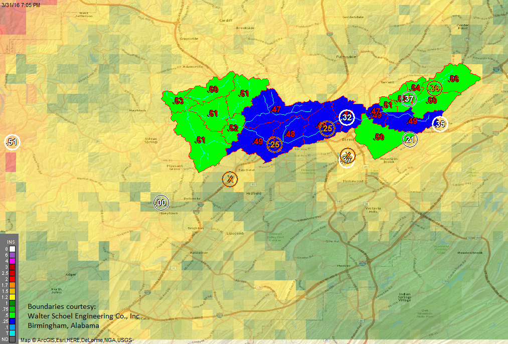
Here is a real world example of GetRealtime installed on a MS Azure Cloud
to provide real-time flood aware web services and custormer alerts 24/7 (Walter
Schoel Engineering):
http://vcfms.azurewebsites
Or check out my 24/7 site run off my old laptop to GoDaddy
when
it's raining here... or
snow melting here.
I keep trying to get these professional guys to add some pizzaz but to no avail.
They know their customers better than some radar rube's idea for throwing all
the spaghetti on the wall like I do.
This FREE suite of programs and
functions include:
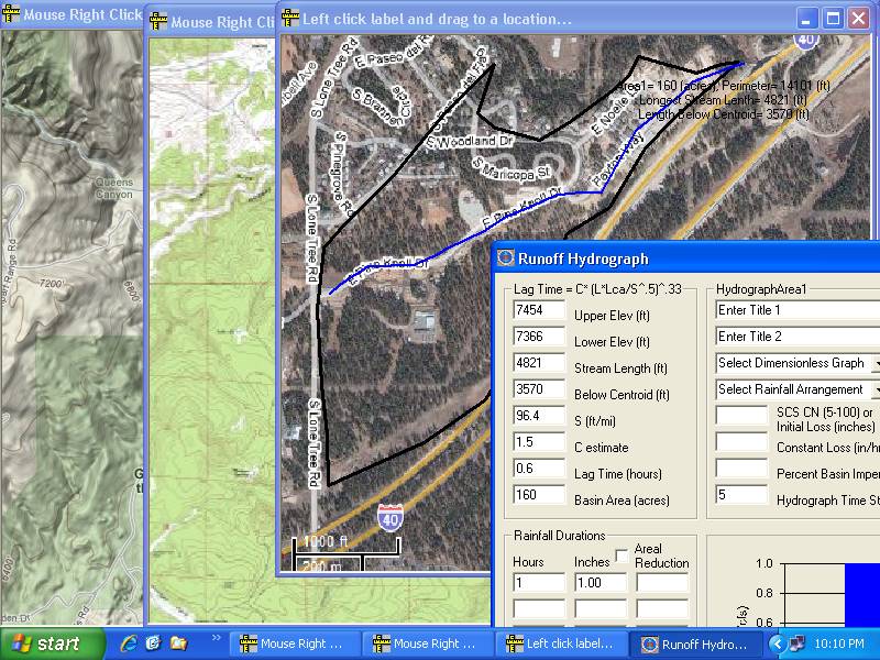
1) GetMapArea -- For us GIS ignorant (just Google Earth) for digitizing basin
boundaries, runoff coefficients calibration, rainfall durations, and hydrograph
shaping. This is how you did it before NED's and DEM's and Shapes and Layers,
but if you already got your boundary lat/longs the hard way, that's ok too.
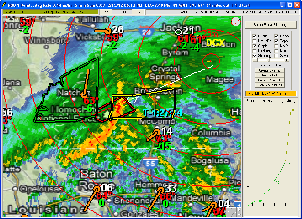
2) GetNexrad -- For current visualization of radar
imagery, historical analysis, basin area averaging, gridded radar output, QPF
forecasting, and radar track Nowcasting... AND storm ETA for NASCAR race fans.
3) GetRealtime -- Downloads current or historical radar imagery, rain gages,
flows, forecasts, and computes gage/radar adjustment and applies them,
incorporates NWS QPF's, storm track Nowcasts, snowmelt, ET, and then simulates
event and continuous runoff and routings with multiple runs and traces and what
ifs which means each real-time forecast and runoff comp can also automatically
be saved for post event analysis. Routings will handle most anything
short of including hourly scheduled
Modpul for
Grand Coulee and it's system of dams and irrigation districts for the next 400 years hourly or 30 years at 5-minutes on my 1.3
gig ram XP. Has 4 Monte Carlo methods for varying any of the runoff
coefficients and the rainfall record/generation for calibration or stochastic
runoff of as many storms for any period you like. GetRealtime can write its
radar adjusted rainfall or its runoff to Hec-DSS files in real-time so that you
could also use Hec-HMS, RAS, ResSim and EPA-SWMM to do your bidding.
GetRealtime can automate RAS or SWMM to do its
unsteady flow routings and read the results back into the GetRealtime system in
real-time and likewise HMS and ResSim. An esteemed RAS user retorts, "I've
never had such good data to do a complete calibration with before. This is
cool!! It used to take about a full day to get the data ready to do calibration
runs. Here, we have the hydrology and the hydraulics working hand in hand to
produce everything." Didn't think you could ever run and link
the HEC programs with automated data sources and a REAL database...
in real-time... well now you can... but unless you are invested heavily in a
current large project, why would you.
4) GetAccess -- Stores the inputs and outputs of all of the above in a simple
Microsoft Access database that writes directly to and from MS Excel (also
HEC-DSS ready format, GetRealtime writes/reads direct dss). Maintains current
and history to keep the Access file within 2 gigs or... use the dreaded
SQLserver or other local/remote servers.
5) GetGraphs -- For viewing all this stuff
and more in real-time and FTPing it up the channels. You will be the master of all you survey, whether that is
a very important sewer
system or just some pretty mountain glacier.
So where do I start???
Kick start a fully operational download project for radar rainfall runoff
at Nashville from my Site
Map page at Start Here! Unzip and just start running it. For
details read
do it yourself
adjusted radar. For an historical example at this site see the epic
2010 Nashville storm
on a small 12 sqmi basin. And email me your questions because you will
have them and I expect you to have the best results possible.
-----------------------------------------------------------------------------------------------------------
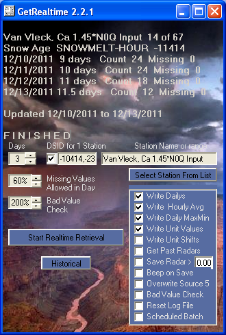
GetRealtime ....just
hit 'Start Realtime Retrieval' and go back to sleep...
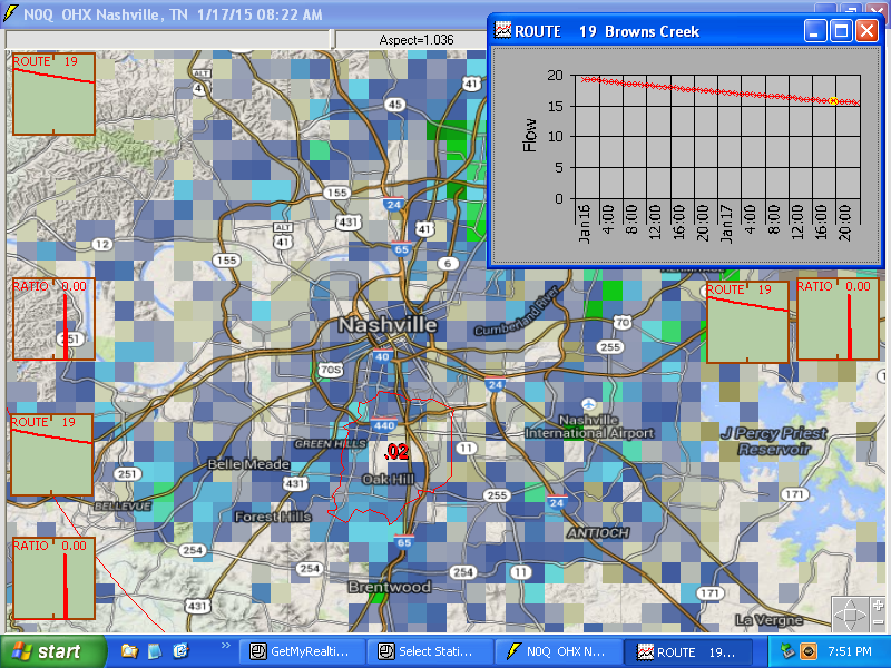
GetRealtime and GetGraphs’ example of many auto paging screens...
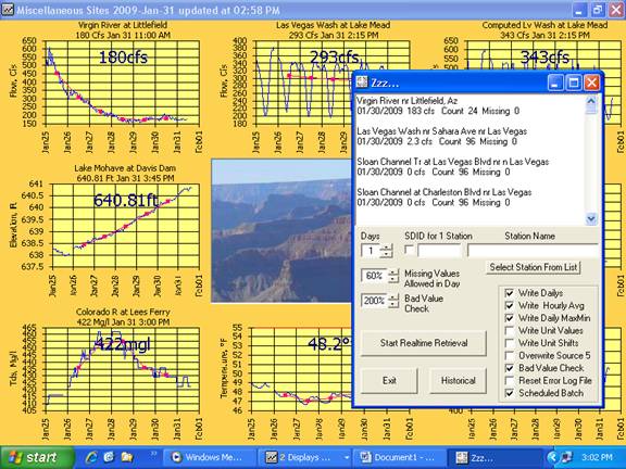
GetNexrad for viewing boundaries, basin radar rain, rain gages, plots and much
much more...
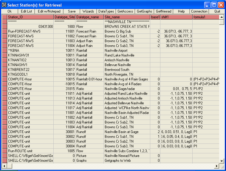
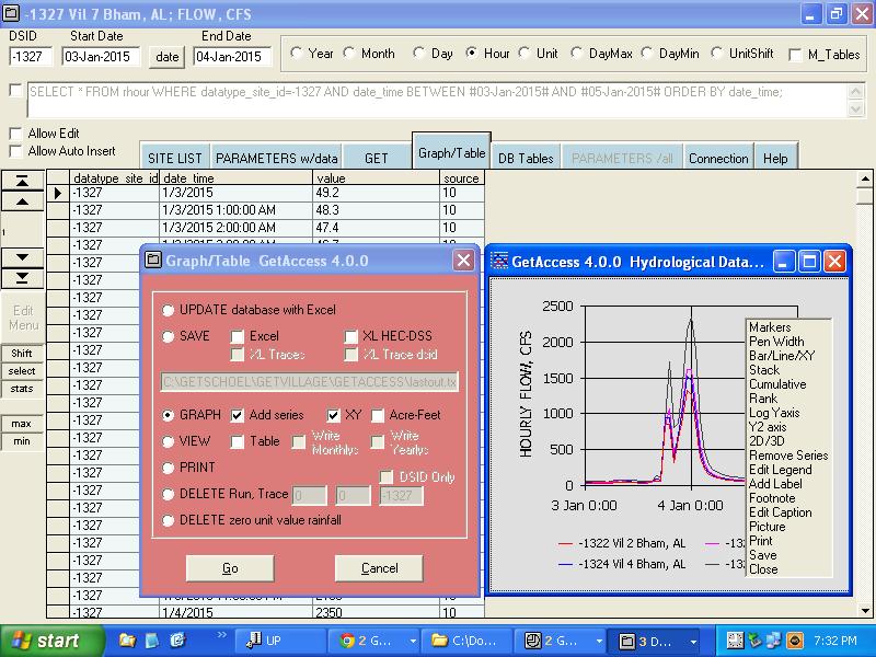
GetAccess for database management
of multi-run what ifs, stochastics, and forecast what were's...
What real-time web data sources are made available by the GetRealtime
system without charge or registration:
1) Weather Underground’s thousands of weather stations around the world
providing info such as Temperature, Humidity, Wind Speed, Dew Point, and
Rainfall.
2) US Geological Survey’s thousands of stream flow, reservoir, and water
quality stations providing info such as Flow, Elevation, pH, Dissolved Oxygen,
Conductivity, Turbidity.
3) California Data Exchange Center providing both hydrological and
meteorological data from hundreds of state and federal sources through out
California.
4) US Conservation Service providing SNOTEL snowpack depths and other
meteorological data throughout the western US mountains.
5) US Bureau of Reclamation providing reservoir, meteorological, and
evapotranspiration data through out the Pacific Northwest and Great Plains
Regions of the US.
6) US Army Corps of Engineers providing reservoir and stream data through out the US.
7) California Irrigation and Management Information System providing
meteorological and evapotranspiration data at hundreds of sites through out
California.
8) NWS 7-day Forecasts, 2-day Snowcasts, AFWS Automated Flood Warning System precip gages.
9) NOAA Nexrad Doppler WSR-88D class radar imagery providing real time rainfall rates that are
converted to areal average rainfall amounts for anywhere in the USA.
10) Canada's 31 C band weather radars real time rainfall
rates that are converted to areal average rainfall amounts.
11) Canada's Water Survey of Canada streamflows and
water levels.
12) Any other ODBC database on your computer or over the
internet. You provide the connection string and SQL statement and away you
go in real-time. Computations can be made on the fly or stored first for more
computations.
13) Your personal weather station or other text
file data.
14) HEC-DSS files using their MS Excel HEC-DSS Add-In or
directly creates and automates Hec-Ras unsteady flow projects.
15) KISTERS QueryServices data.
16) SpotWx weather forecast models such as hourly HRRR and
RAP.
17) Iowa Environmental Mesonet at Iowa State University
airport metars and most all radar images.
18) MesoWest at University of Utah APRSWXNET/CWOP personal
weather stations (now of limited use, see Synoptic or Madis.
19) Synoptic personal
weather stations (MADIS) but free registration may limit your use. More
use comes with a free.
20) NOAA Madis uses same weather station names as Synoptic
and MesoWest plus more and is intended for heavy use every 5 minutes in batch
mode (about 4 seconds). Historical data is there but takes about a minute
per hour for every station in the US and beyond.
21) The World Wide Web providing screen shots and gifs such as weather
radar loops, webcams,
current assessments, current prices, and just about
everything else imaginable.
What kinds of computations can be made real-time during the GetRealtime retrieval:
1) Conversions such as Temp C to Temp F, gage height to elevation, and
metric to English or English to Metric.
2) Computation of stream flow from gage heights, gate openings, and such
with shifts applied with stage and time.
3) Convert rainfall, snowpack, reservoir contents to percent of normal.
4) Convert reservoir elevation to contents.
5) Computation of both tall(alfalfa) and short(grass) hourly reference ET
from Temp, Humidity and Wind Speed at Wunderground weather stations using
methods of the ASCE Standard Penman-Monteith with a special solar computation if
solar not available.
6) Compute crop and lawn water use from the computed reference ET.
7) Convert Dissolved Oxygen to percent saturation.
8) Convert conductivity to TDS.
9) Compute Absolute Humidity from Temp and RH.
10) Compute pumped waste inflow based on current flow.
11) Compute diurnal sewer plant inflow given daily average.
12) Compute Soil Flood Potential.
13) Compute rainfall-runoff from weather station rainfall
or average of stations and display
routed and combined hydrographs.
14) Compute rainfall-runoff from adjusted NOAA Nexrad radar rainfall imagery and display
routed and combined hydrographs for real-time and continuous simulation.
Add automated Nowcasts for 1 to 3 hour lead time rainfall, GetRealtime's Forecast Wizard
for manual updates... and add HRRR 18 hours and NWS QPF quantitative precip
forecasts for 7 days more lead time. The HRRR 18 hr radar forecast loop
will knock your socks off!
15) Continuous snowpack and melt record for realtime rainfall-runoff and display
of
routed and combined hydrographs for real-time and continuous simulation.
16) Get, Combine, Subtract, Divert, Release, Add, and Route unlimited number of
sub-basins with Tatum, Muskingum, and Cascading Modpul routings and an adjusted
Modpul factor.
17) Operate an irrigation district and/or complex reservoir system top to bottom
and set releases and diversions based on your own priortity system and instream
needs by shelling your own rule program or use GetRealtimes 5 equations and
setup line IF execution to set
them with a 5-minute/hourly time step for the next week, month, season, or
years. Getrealtime provides realtime rainfall and 7 day forecast so you
are already WAY ahead in operations and water cuts.
18) Or just about any computation you can put in the form of up to 5 equations
relating the multiple parameters being retrieved and can include date and time,
shifts, and conditionals for which to use.
Setup Wizards for computation of radar rainfall, radar
adjust, runoff, snowmelt, ET, solar radiation, long wave radiation, and stream
flow routing. Evan
beginners can turn a nearby Wunderground weather station into a cornucopia of
scientific information.
Need a simple alternative to HEC-HMS Green-Ampt and don't think you can use your
favorite loss method like the SCS CN method in a continuous model... think
again. GetRealtime's rainfall-runoff lumped model simulation parameters can fit
the recessions and groundwater returns from bogs to rock bottoms.
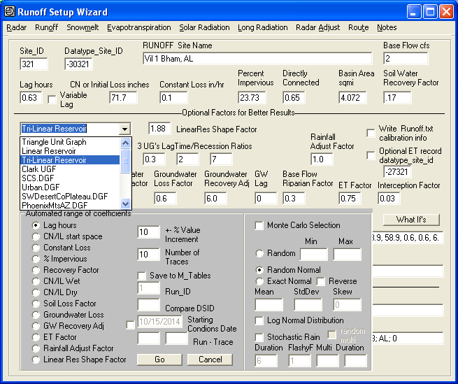
Minimum required parameters from the user for runoff simulation:
1) Lag time to peak in hours.
2) Basin area in square miles.
3) Initial Loss or SCS Curve Number.
4) Constant Loss in/hr.
5) Percent impervious %.
6) Soil Group (A,B,C,D) for soil recovery factor..
Additional parameters with defaults the user can supply:
1) Time-step, 1-day, 1-hour, 5-minute.
2) Unit-graph modification with 5 straight forward parameters for peak,
interflow, and recession shaping...
...or select from several dimensionless graphs like SCS, urban, USBR regionals,
Clark 2 parameter,
and linear reservoir.
3) Rainfall adjust factor.
4) Wet and Dry SCS curve number limits.
5) Groundwater storage recovery factor.
6) Groundwater base flow.
7) Groundwater loss factor.
8) Impervious directly connected factor.
9) Interception factor.
10) Water use factors (Kc) for adjusting reference ETo
and a seasonal riparian ET adjustment factor.
11) Kansas default ETo or computed ETo record (ASCE Penman-Monteith calculation
with all defaults provided except the Temp, Wind, Humidity record usually from
any Wunderground station).
12) Snowpack and melt applied to rainfall record (Physical 1 layer
heat transfer model with
all defaults provided except the Temp, Wind, Humidity record).
Rainfall-Runoff simulation setup wizard:
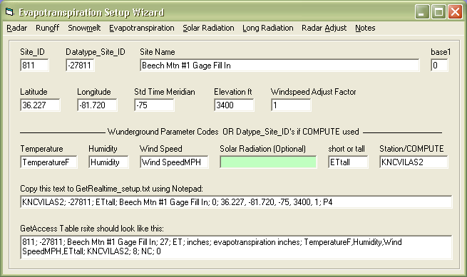
ET evapotranspiration setup wizard for those not in Kansas anymore:
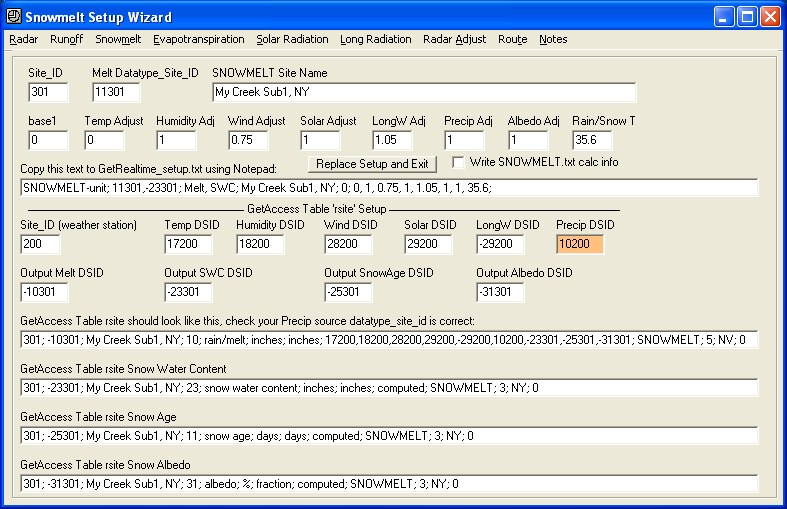
Snowpack and melt setup wizard (solar and longwave radiation will be computed):
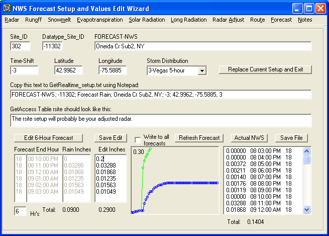
QPF forecast wizard:
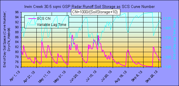
SCS Curve Number method adapted for continuous simulation with variable lag
time:
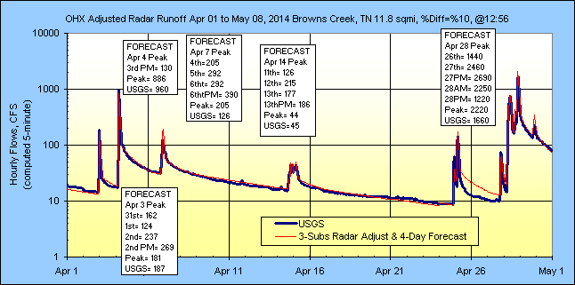
Continuous
2 gage adjusted radar SCS CN runoff and 4 day NWS QPF forecasts:
And with enough routing methods to keep both California and Arizona guessing.
Don't see what you need? Just contact me below.
System Requirements:
Microsoft Windows 98 or better... like XP, Vista, 7, 8, 10... Owning MS Access
is not required, see Free Downloads runtime but I think it ships with Vista and
above.
Please use these programs freely, but if you would like to remove the nag screen
on startup for GetGraphs and GetMapArea and keep me on your good side then you will need a registration number
from here.
... And some more stuff
GetNexrad Screen Shot (It's Free):
GetMapArea Screen Shot (It's Free):
Additional page links about
ET, Runoff, and Nexrad Radar help and comparisons:
Real-time Flood Alert Web Example for Snowmelt on Irrigation System
Getting Started with Adjusted Radar Rainfall
Adjusted Radar Comparisons at USGS Rain Gages
Help Page for GetNexrad.exe
Video
review of GetRealtime featuring GetRealtime by John Bittorf
About the webmaster:
*
10 years as field man, flood and surface water records hydrologist with the US
Geological Survey.
*
20 years as
office man and modeler in flood and water supply
studies with the US Bureau of Reclamation.
* Currently unemployed man.
Got a question, shoot me an email. I've got nothing
better to do... till NASCAR starts. If anyone would like me to provide a setup
for their location to get them started, or review their setups, or participate
in a study in anyway I would be happy to do so for FREE!
The brains behind the outfit ...and goto mule skinner Dave (he
actually works or did).

Label
|
|