|
Current
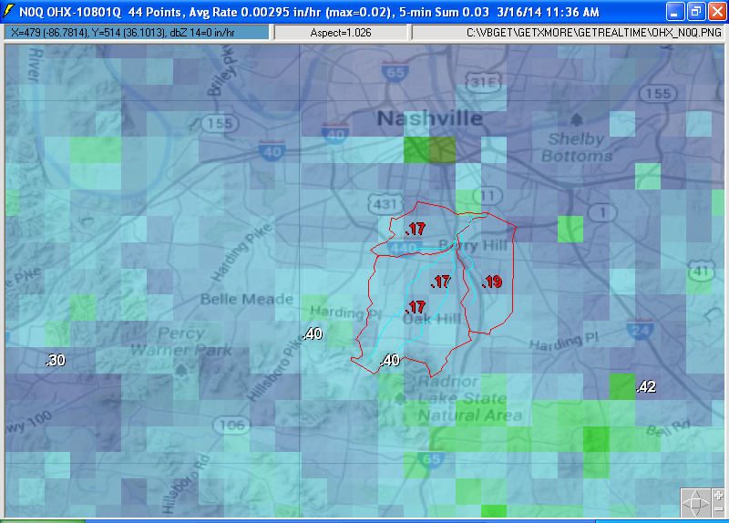
NOAA N0R radar lite gif above
with Browns Creek Basin overlay. Below is zoomed N0Q radar, Wundergages, and
adjusted N0Q at watersheds. Note that the raw N0Q radar here almost always
shows "ground clutter" because of being so close to the radar site. Ground
clutter (0.05" to 0.1" a day) is just another simple matter that rain gage
adjustment removes. No rain at the rain gages for the hour then no radar rain.
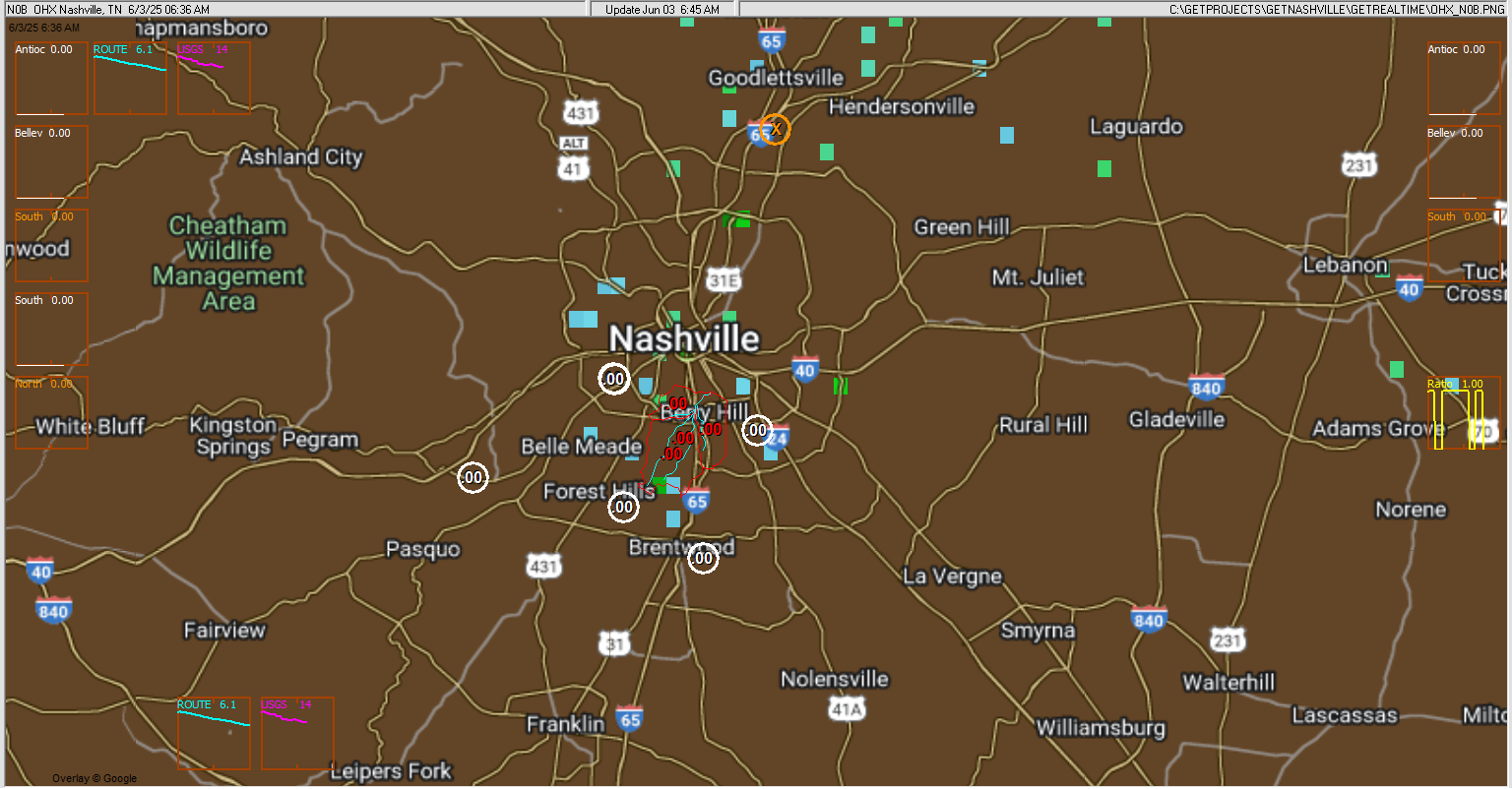
Automated graphs and radar updates:
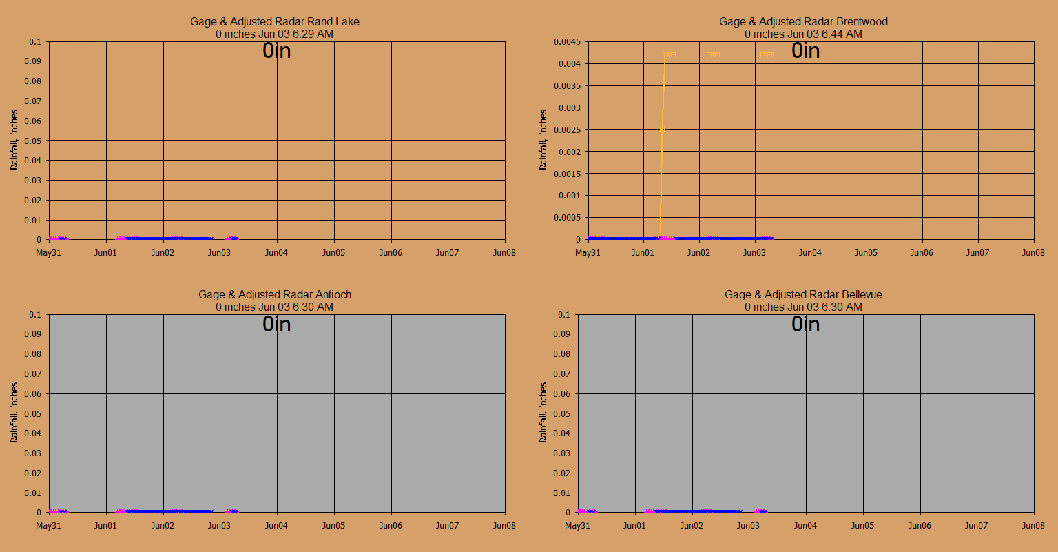
Wundergages and radar:
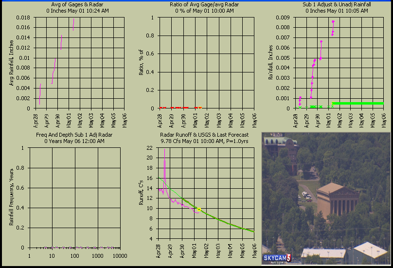
Adjusted and Raw Radar at Gages:
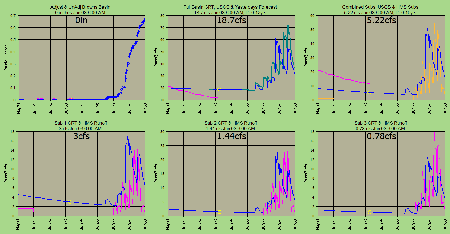
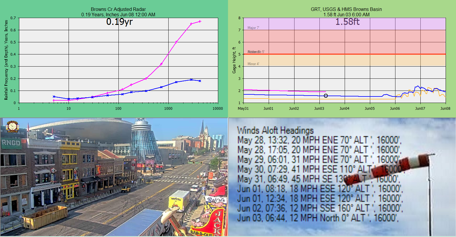
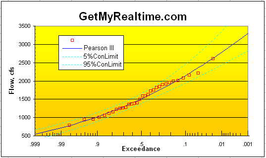
Basin Adjusted Rainfall, GRT vs HMS runoff:
Basin Rainfall Frequencies, Nowcast Winds Aloft and Flood Stage:
This is a quick study to show
that with a day or 2 of your time that you can setup a
real-time multi-subbasin radar rainfall compuatation using GetRealtime.
A small 11.8 sqmi basin in subburbon residential Nashville, TN was
selected with a USGS gage. The initial lumped basin runoff coefficients
were cookbooked and then evaluated with the USGS gage and revised as needed.
The revisions needed were for very large recession flows presumedly for deep
soils with a lot of night crawler and gopher activity or an imperivious layer at
the gage. The CN loss was not adjusted but my normal large soil and
groundwater losses had to be greatly reduced as well as speeding up soil
drainage and weighting and extending
my 3-triangular unit graphs recession and now all seems well. Probably due
to the large average residential lot size and not reworking the soils too much
during construction and never dismiss them worm holes and varmits.
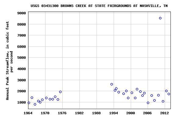
USGS 03431300 BROWNS CREEK AT STATE FAIRGROUNDS AT NASHVILLE, TN
Next the basin was subdivided into 3 subbasins and the lag times and base flow
were distributed with area size of the original lumped basin size. I had thought one sub in paticular would
need much higher % impervious but has not been adjusted yet (update, it was
4/3/2014). (Note: If
your lag times start to go below 0.5 hours you should switch your unit graph
method to the 3 linear reservoir method which should give the same resultes
around 0.5 hours but you'll be glad you did. GetRealtime makes this
an easy selection.) Pretty
simple, so let's see what I did and then how we do.
After selection of the basin, I fired up my free GetMapArea to create the
lat/long boundary file needed for radar rainfall. I used 'Load Map File', 'EPA
WATERS KMZ', which loads Google Earth and the catchments and streamlines and 2
diagonal Lat/Long points for scaling. I know for you GIS gurus this seems stone
age but it still works and probably better than your methods at times and so
what's your lag time smart ass? Below is the 'Ctrl*PrtScr' captured image
used in GetMapArea with diaganol scaling points:
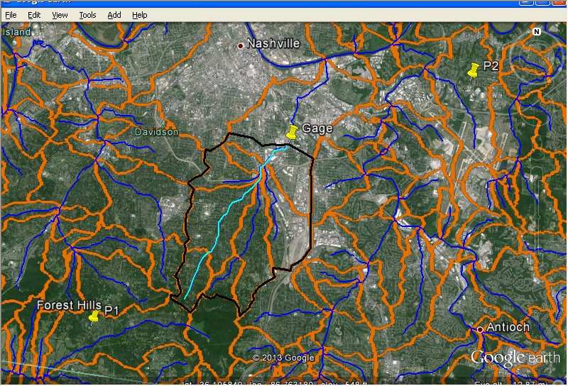
My notes needed for creating the boundary and lag time:
SID=801
P1,P2 Scalinng: -86.852670,36.061461,-86.676659,36.153219
11.8 sqmi
so says the USGS, we shall see.... bingo on the dot!
Longest Stream Lenth= 5.13 (mi)
Length Below Centroid= 2.56 (mi)
Upper Elev=800 ft
Lower Elev=443 ft
C=26*N=26*0.035=0.91
Lag=1.06 hours GetMapArea computation
Lag Time=C*(L*Lca/S^.5)^.33
16 Houses in: 653 ft x 765=499545 sqft= 11.47 acres or 16/11.47=1.39 acre lots
(*oops* I used 1.39 acre lots but should be 11.47/16=0.72 acre lots.)
Soil Groups: 72.7%= Silt loam= B
15.4%= Silt loam= C
Silt loam B, Carson's Recovery Factor=0.17
From SCS TR-55 table: 1 acre resedential on B soil, CN=68, % Impervious=20%, %
Connected=40%
See The Cookbook:
http://getmyrealtime.com/HarvardGultchExample.aspx
Now we need to convert our lat/long boundary to radar pixels for radar OHX
Nashville. You use LatLongPixelsFromFile.exe to convert your GetMapArea boundary
text file to pixles, copy to your GetRealtime radar image folder and create the
point file for it using GetNexrad.exe. I also digitize the stream lines for
radar display and do the same using DSID=1 but no point file is created.
Next we need at least 2 Wundergages to adjust the radar:
-10811 KTNNASHV31 Rand Lake Nashville
DOWN
Lat: N 36 ° 4 ' 7 '' ( 36.069 ° ) Lon: W 86 ° 47 ' 55 '' ( -86.799 ° ) Elevation
(ft): 800
-10812 KTNNASHV42 Forest Hills Nashville
DOWN
Lat: N 36 ° 4 ' 56 '' ( 36.082 ° ) Lon: W 86 ° 49 ' 42 '' ( -86.829 ° )
Elevation (ft): 912
And here are 2 more in case wee need them
(update and these are the only 2 operational now):
-10813 KTNANTIO2 Antioch, TN (-86.694, 36.066)
UP
-10814 KTNNASHV1 Bellevue, TN (-86.938,36.077)
UP
added 3/19/2014:
-10816 KTNNASHV24 Oak Hill, TN (-86.794,36.080)
DOWN
added 5/19/2014:
-10817
KTNNASHV39 WCPike North Nashville, TN (-86.825,36.246 UP
(if needed: KBNA airport (-86.6892, 36.1189
but I hate airports)
Use my free LatLongPixels.exe to create the Wundergage's boundary files and the
point files.
And the subdivided subbasins:
SID 802 Browns Cr Sub 1 (Upper South) Area sqmi: 6.506471
SID 803 Browns Cr Sub 2 (Lower East) Area sqmi: 3.278148
SID 804 Browns Cr Sub 3 (Lower West) Area sqmi: 2.01575
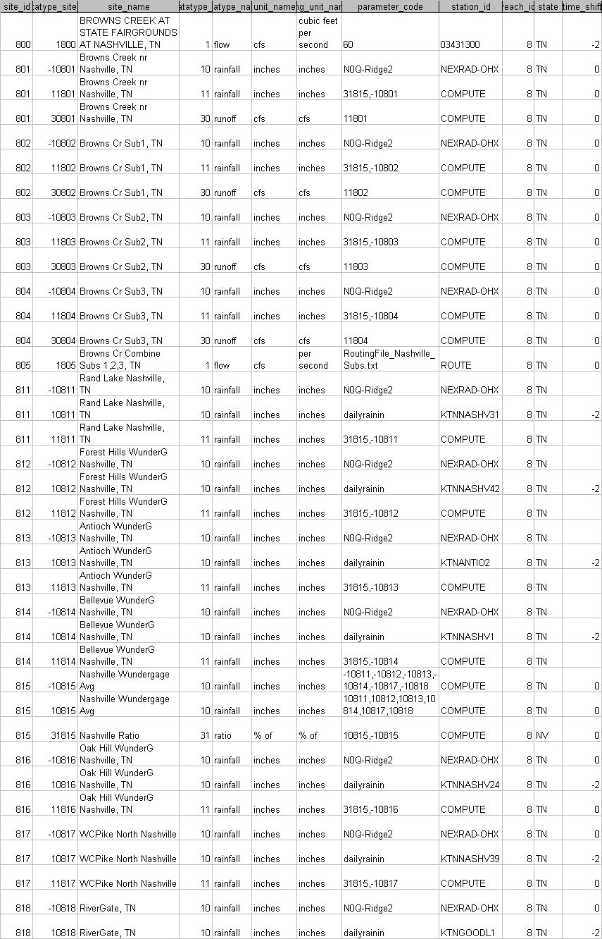
GetRealtime_setup.txt:
Station_ID; Datatype_Site_ID; Datatype_Name; Site_Name; base1; shift1;
formula1;....
***;***;****; *** USGS Gage ****
03431300; 1800; Flow; BROWNS CREEK AT STATE FAIRGROUNDS AT NASHVILLE, TN
***;***;****; *** Radar ****
NEXRAD-OHX; -10801; Rainfall; Browns Creek Basin, TN; 0
NEXRAD-OHX; -10802; Rainfall; Browns Cr Sub1, TN; 0
NEXRAD-OHX; -10803; Rainfall; Browns Cr Sub2, TN; 0
NEXRAD-OHX; -10804; Rainfall; Browns Cr Sub3, TN; 0
NEXRAD-OHX; -10811; Rainfall; KTNNASHV31 Rand Lake Nashville; 0
NEXRAD-OHX; -10812; Rainfall; KTNNASHV42 Forest Hills Nashville; 0
NEXRAD-OHX; -10813; Rainfall; KTNANTIO2 Antioch Nashville; 0
NEXRAD-OHX; -10814; Rainfall; KTNNASHV1 Bellevue Nashville; 0
***;***;****; *** Forecasts ****
FORECAST-NWS; 11801; Adjust Rain; Browns Cr Big Sub to Gage; -2;
36.0713,-86.777,2 FORECAST-NWS; 11802; Adjust Rain; Browns Cr Sub1, TN; -2;
36.0713,-86.777,2
FORECAST-NWS; 11803; Adjust Rain; Browns Cr Sub2, TN; -2; 36.0713,-86.777,2
FORECAST-NWS; 11804; Adjust Rain; Browns Cr Sub3, TN; -2; 36.0713,-86.777,2
***;***;****; *** Wundergages ****
KTNNASHV31; 10811; Rainfall; Rand Lake Nashville
KTNNASHV42; 10812; Rainfall; Forest Hills Nashville
KTNANTIO2; 10813; Rainfall; Antioch Nashville
KTNNASHV1; 10814; Rainfall; Bellevue Nashville
***;***;****; *** Computations ****
COMPUTE-Hour; 10815; Rainfall; Nashville Avg of 2 Rain Gages; 0; 0;
(P1+P2+P3+P4)/N
COMPUTE-Hour; -10815; Rainfall; Nashville Avg of 2 Radars; 0; 0; (P1+P2+P3+P4)/N
COMPUTE-Hour; 31815; Ratio; Nashville Gage/Radar; 0; 0.01, 1, 5; P1/P2
COMPUTE-unit; 11811; Adj Rainfall; Adjusted Rand Lake Nashville; 0; -1, 1,0.75,
0.50; P1*P2
COMPUTE-unit; 11812; Adj Rainfall; Adjusted Forest Hills Nashville; 0; -1, 1,0.75, 0.50; P1*P2
COMPUTE-unit; 11813; Adj Rainfall; Adjusted Antioch Nashville; 0; -1, 1,0.75, 0.50; P1*P2
COMPUTE-unit; 11814; Adj Rainfall; Adjusted Bellevue Nashville; 0; -1, 1,0.75,
0.50; P1*P2
COMPUTE-unit; 11801; Adj Rainfall; Nashville Basin Adjusted Radar; 0; -1, 1,0.75, 0.50; P1*P2
COMPUTE-unit; 11802; Adj Rainfall; Browns Cr Sub1, TN; 0; -1, 1,0.75, 0.50; P1*P2
COMPUTE-unit; 11803; Adj Rainfall; Browns Cr Sub2, TN; 0; -1, 1,0.75, 0.50;
P1*P2
COMPUTE-unit; 11804; Adj Rainfall; Browns Cr Sub3, TN; 0; -1, 1,0.75, 0.50;
P1*P2
***;***;****; *** Runoff ****
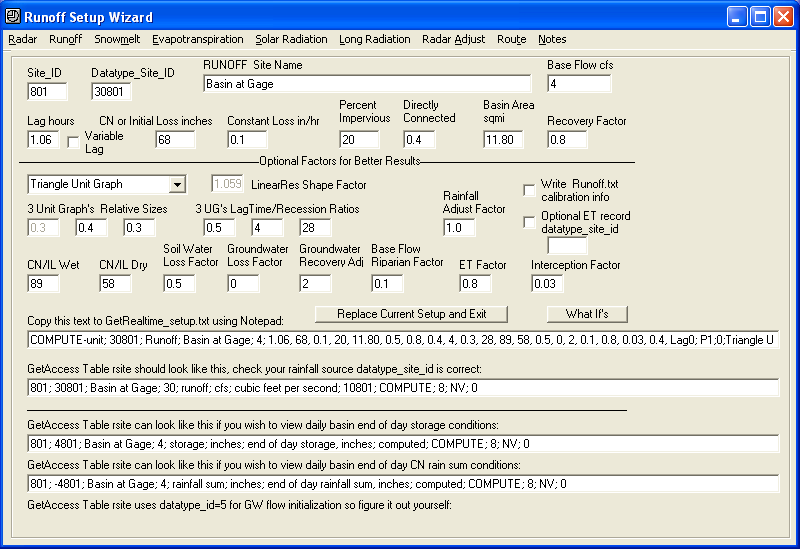
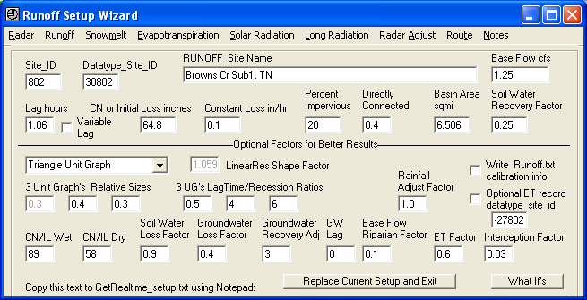
COMPUTE-unit; 30801; Runoff; Nashville Basin at Gage; 4; 1.06, 68, 0.1, 20,
11.80, 0.5, 0.8, 0.4, 4, 0.3, 28, 89, 58, 0.5, 0, 2, 0.1, 0.8, 0.03, 0.4, Lag0;
P1; 0; Triangle Unit Graph
COMPUTE-unit; 30802; Runoff; Browns Cr Sub1, TN; 2.21; 1.06, 68, 0.1, 20, 6.506,
0.5, 0.8, 0.4, 4, 0.3, 28, 89, 58, 0.5, 0, 2, 0.1, 0.8, 0.03, 0.4, Lag0; P1; 0;
Triangle Unit Graph
COMPUTE-unit; 30803; Runoff; Browns Cr Sub2, TN; 1.11; 0.5, 68, 0.1, 20, 3.278,
0.5, 0.8, 0.4, 4, 0.3, 28, 89, 58, 0.5, 0, 2, 0.1, 0.8, 0.03, 0.4, Lag0; P1; 0;
Triangle Unit Graph
COMPUTE-unit; 30804; Runoff; Browns Cr Sub3, TN; 0.68; 0.5, 68, 0.1, 20, 2.016,
0.5, 0.8, 0.4, 4, 0.3, 28, 89, 58, 0.5, 0, 2, 0.1, 0.8, 0.03, 0.4, Lag0; P1; 0;
Triangle Unit Graph
ROUTE-unit; 1805; Flow; NashVille Subs Combine 1,2,3, TN
(note routing file was simple combines)
***;***;****; *** Post Current Radar and Map on Web ****
SHELL-C:\GetRealtime\GetNexrad\GetNexrad.exe -2 myPassword; 0; Pic; Nashville
Radar Pic; -1
END
GetAccess table Rsite:
5-minute radar N0Q cells are 0.57 x 0.71 miles (1km x 0.5 dBZ):
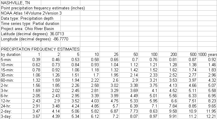
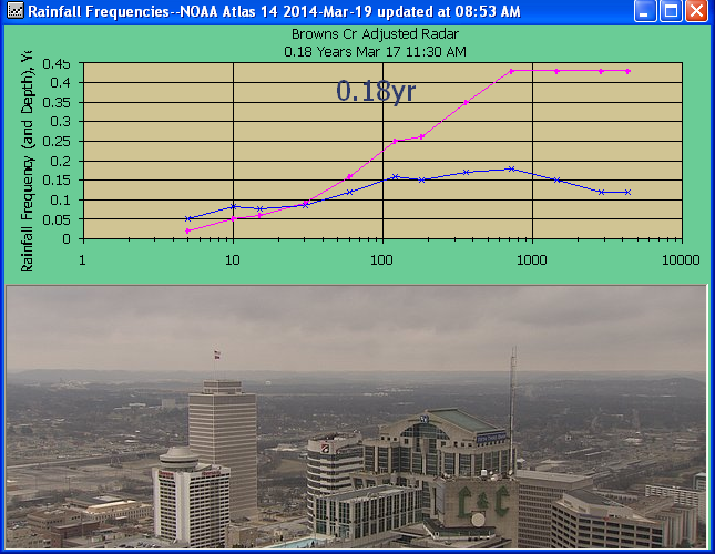
NOAA Atlas 14 frequency table used by GetGraphs above:
Interesting... did you note how the peaks of the 1960's-70's seem to be from a
different population of mean and variance than the post 1990's. Global
Warming! I mean Global Cooling! Or maybe they built more houses to keep
warm? Which caused the warming, I mean cooling. What ever pays the most
I'm always for. And seeing the 2010 outlier I decided to do this
historical event as shown at the bottom.
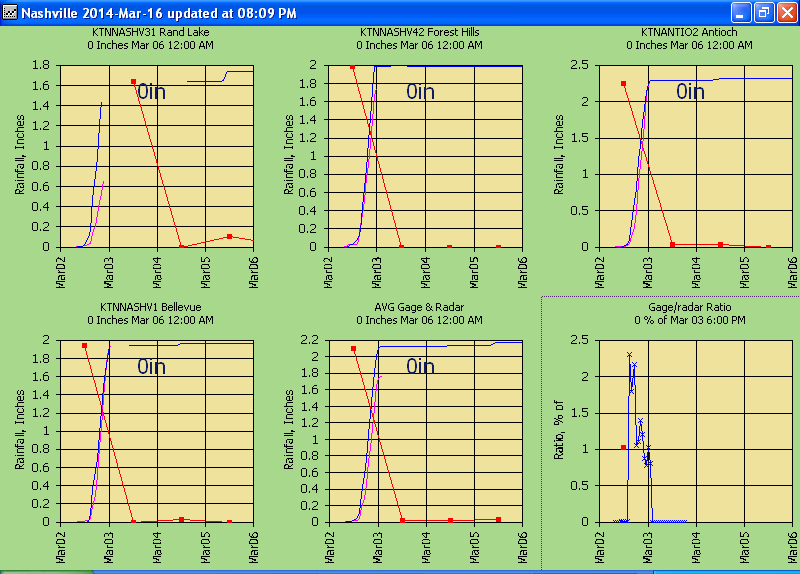
The calibartion of March 2, 2014 Wundergages and OHX Radar
using GetGraphs hourly display:
NOTE: The violet colored series is always
the 2nd series referred to. As a quick example the graphs
shown are the real-time graphs of my GetGraphs.exe and what a user sees in
real-time.
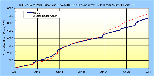
The calibraion of the lumped and subdivided runoff,
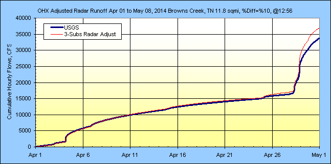
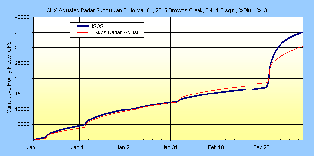
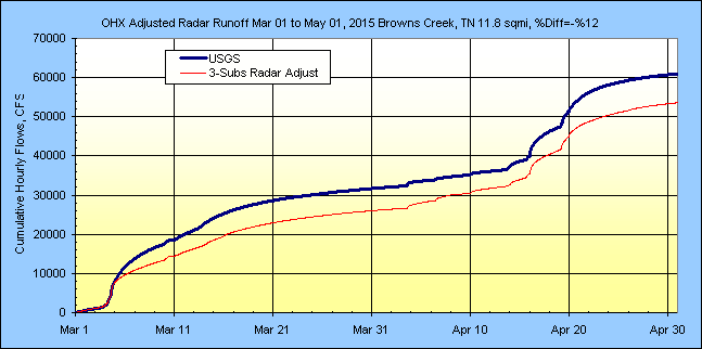
USGS is violet:
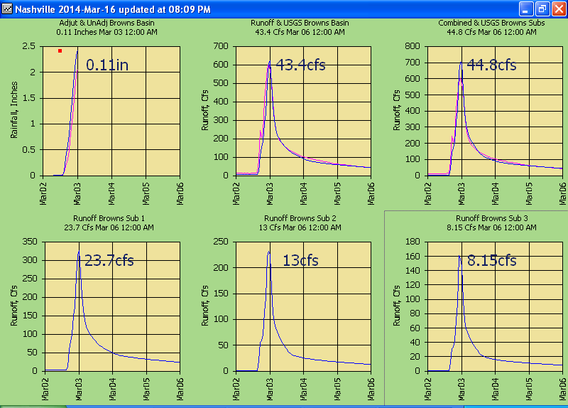
Two days to get things setup and we are all set to see how things work
out....
REAL 5-MINUTE EVENTS IN REAL-TIME
And we are off>>>Mar 16, 2014:
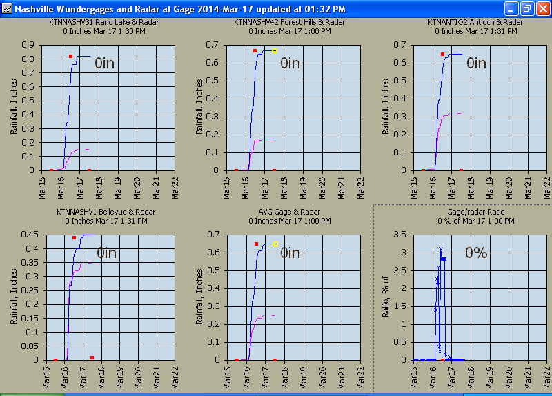
The radar at the gages
displayed hourly... base flow raised from 4 to 8 cfs but reset to 2 after
thinking that the soils just need some initialization and other factors will be
changed soon enough.
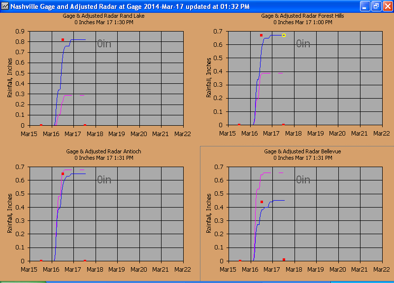
The adjusted radar at the
gages...
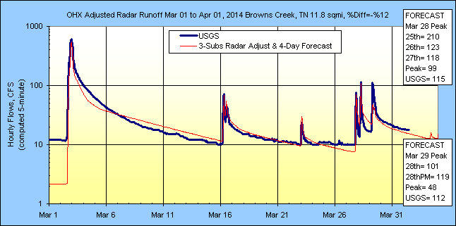
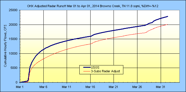
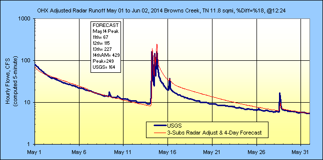
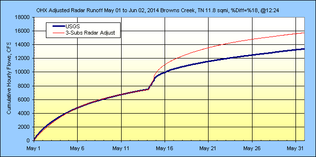
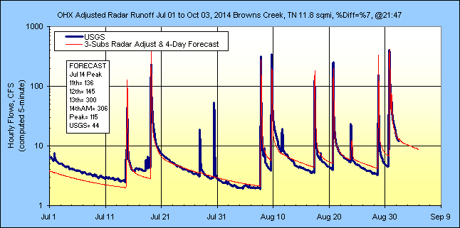
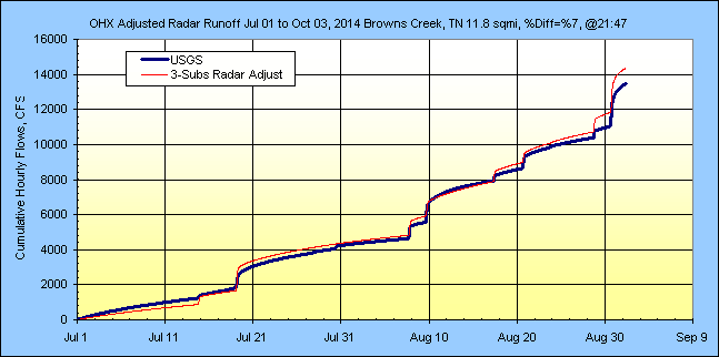
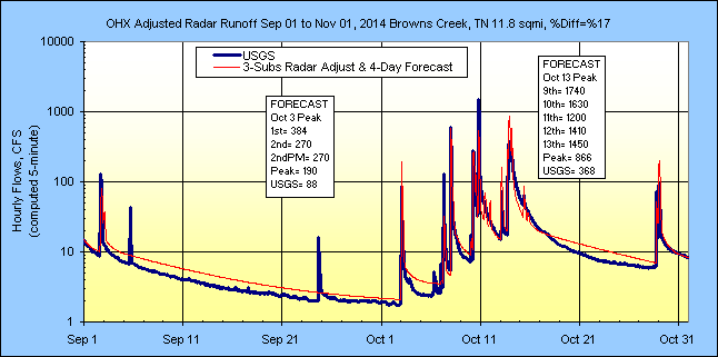
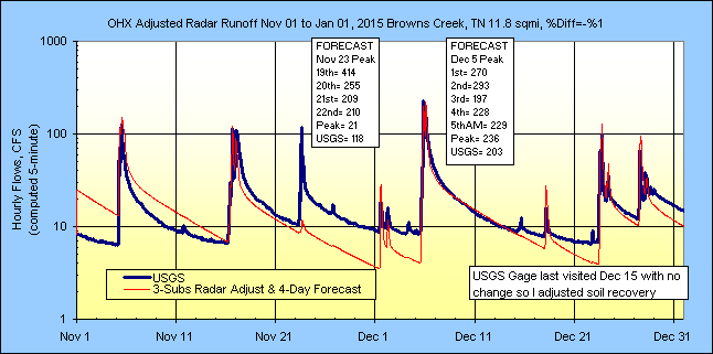
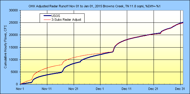
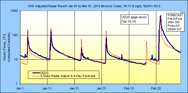
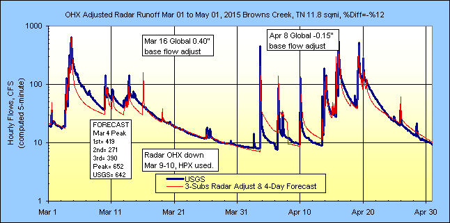
The adjusted radar runoff with 4-day forecast and
USGS...
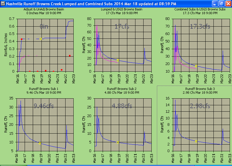
Adjutsted basin radar rainfall freqency and
depth at x-scale minute durations....
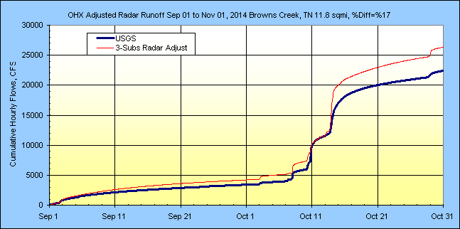
Hourly runoff by month:
(Month1: Update 3/20/2014, Soils need initialization befor fine
tuning so I have decided to just fit the longer recession for now and hope the
peak recession fixes itself. I will update the setups once this occurs.)
Month 2:
Northeast Sub 2 with industrial and commercial area percent impervious raised
from 20% to 50% and directrly connected raised from 0.4 to 0.8. This did
not change the historic 5/2/2010 peak but doubled the small 4/3/2014 peak here.
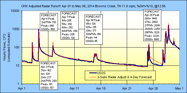
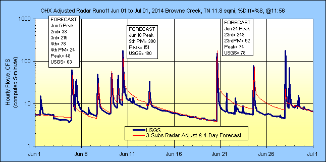
Month 3:
From the Month 2 peaks it looks like I raised the % impervious a wee too much.
I will adjust when a new peak comes in for May. Below is the current
coefficients for the large Sub 1 which is almost the same as the the other two.
I increased the recover rate to steepen the recession and shifted the increased
soil flow to the more rapid groundwater flows. Base flow increased to 4
cfs and soil losses increased a bit.
Month 4:
No change.
Month 5: Recovery factor lowered from 0.4 to 0.25 to lower recession, base
triange lowered, dry CN raised, and groundwater recovery factor adjusted.
Hey, it's getting there.
Months 6 & 7:
Months 8 & 9:
Months 10 & 11:
Months 12 & 13:
SCS Curve Number method adapted for continuous simulation:
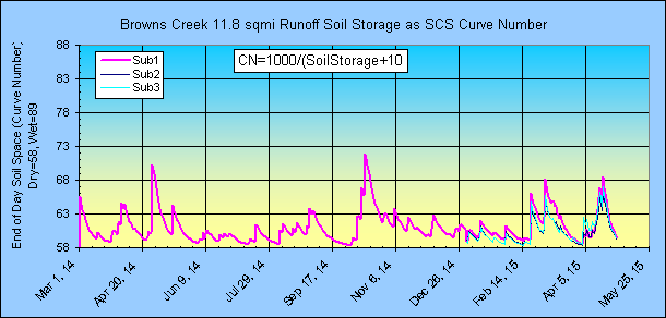
Current Sub1 runoff wizard coefficents:
More runoff to come....
***************** History in the Making *********************
REAL 5-MINUTE HISTORICAL EVENT May 1-2, 2010... WOW!!!
I used the NWS Weather Toolkit to download the May 1-3, 2010 N0Q radar which is
never fun but somebody has to do it (Iowa Mesonet missed these). The
Wundergages all crapped out so I used the nearby (2.5 miles east) KBNA airport
Wundergage to adjust the radar as a last resort. The USGS flow gage also crapped out so only their peak
of 8,540 cfs on May 2, 2010 is available. I had to develop a flow rating
to fill in what is shown below Q=15.95*(GH-0.43)^2.4491 from USGS gage heights and should be very good. The airport adjusted radar
subdivided peak came in as 7,900 cfs so thats good. The radar showed cells
continously above hail condaminated dbz >55 with a continuous maxima about 58-60
dbz and up to 64 dbz on the scope but over all the gage corrected hail capped radar z-r seems
adequate for this storm. No reports of hail for this periord. I deleted the N0H target type
so forget about downloading it twice, dang! I also tried using a daily Airport/Radar ratio instead of
hourly but that really reduced both day's peak flows so no help there.
I searched and found 5 reporting widely scattered Wundergages and only one had a 5-minute
rainfall above the hail cap and was just barely above at 6.12 in/hr so with storm
cells moving at 63 mph you get one shot so no loss of sleep there. Anyway what is
eye-popping is the 2,250 year recurrance 2-day storm duration and this is for a
11.8 sqmi basin rainfall average (but lag time is 1 hour). No wunder the gage washed out. So when the next big
one hits, you better have your radar trimmed and burning because the flow gages
may not be there.
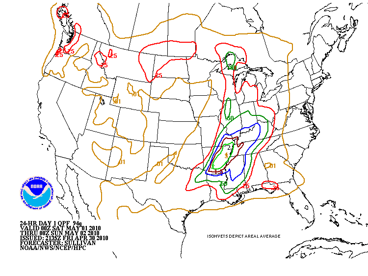
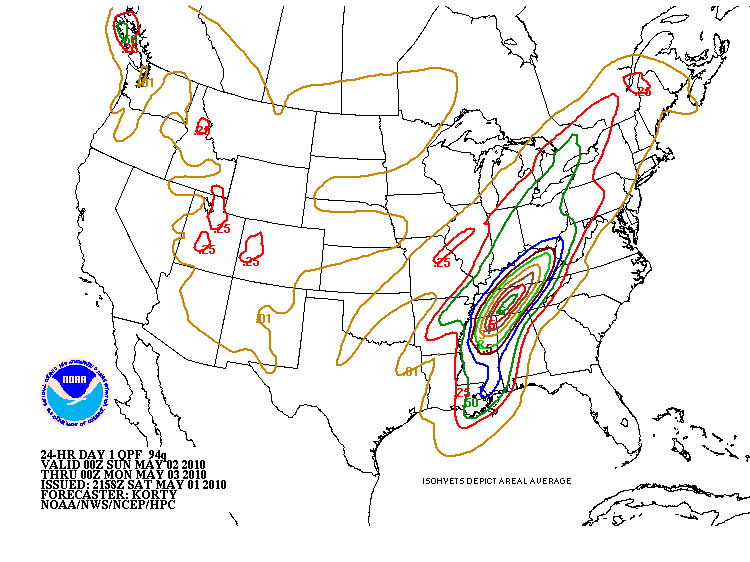
I wonder what the forecast was??? See below.

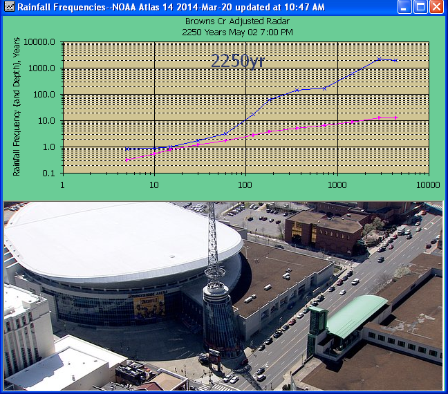
The first wave of the storm was a 169 year 12-hour event then followed the next
day by a 148 year 6 hour event. The odds of that occurring in Nashville
apparently is 1 in 2,250 years from a linear rainfall vs log recurrance
extrapolation beyond 1000 years in NOAA 14. As for the 8540 cfs USGS peak
flow, based on just the log Pearson stats ignoring regional skew, the mixed
population, and this peak,
the 8540 cfs has a recurrance somewhere out there past the age of the earth.
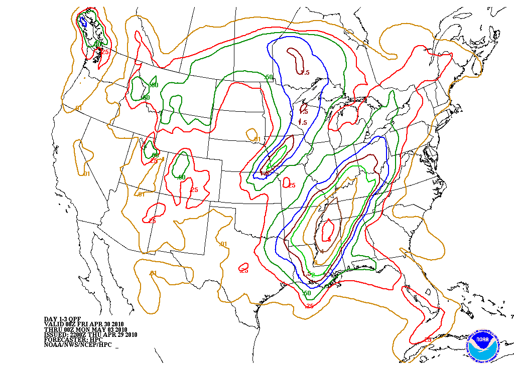
Here was Apr 30, 2010 at 0:00 Zulu (-5 hr dls so Apr 29 7 pm PM's shift, not
grave yards) 3-day forecast of 3 inches which should have put up an alert to
most in this business. May 1, 2010 24 hour forecast at 0:00 Zulu at the
start of the storm shows 1" for Nashville, nice try but 700% low.
Forcasting a 169 year event as 0.41 yr event is missing the bullseye a wee bit,
but was headed in the right direction with a forecast 3" for next day May 2.
After the May 1 deluge, the May 2 0:00 Zulu forecast shows 6", which is dead on,
and certain doom to follow. You really have
to view the radar loop that shows a frontal prarrie fire of rain descend on
Nashville out of nowhere and just continued to burn for 2 days. What I
find interesting on these extreme events in the Southeast is the lack of hail...
or everyone has better things to do than report on it:
The official spin:
http://www.nws.noaa.gov/os/assessments/pdfs/Tenn_Flooding.pdf
"The primary recommendation identifies the need for improved communication and
collaboration between WFO Nashville, the OHRFC, USACE Nashville (LRN) and the
Tennessee USGS." -- Beggar thy neighbor. Sounds like they all should have been
using GetRealtime on Windows with their GetAccess database in DropBox for better
communication!
Download the Nashville N0Q Radar images
for May 1-2, 2010, 58 mb and view with GetNexrad and create return frequencies
for any point you click.
If you would like to run the Nasville 3 day storm over your basin, download the
OHX zip file, unzip, and rename or copy KOHX_*.* Kyyy_*.* where yyy is your
radar id. In the now named HTX_N0Q_0.Kfw, change the lat/long values to
somewhere to the northwest of your basin location. You can try different
lat/longs to try and maximize rainfall over your basin.
6.27910352405173E-03 0 0
-6.27910352405173E-03
-88.5013032769104
37.5352091950734
Now treat these files as if you downdloaded them as a KML download from the
Weather and Climate Toolkit and convert or copy(?) your boundarys and point
files to this folder and there you go. GetNexrad or even GetRealtime can read
and compute the rainfalls for your basins
OR... put the Nasvhille hourlys in both runit and rhour with GetAccess and
'UPDATE database with Excel':
|
Pacific DST |
Adjusted |
Radar |
|
5/1/2010 |
0 |
0.01159 |
|
5/1/2010 1:00 |
0 |
0.02813 |
|
5/1/2010 2:00 |
0 |
0.02263 |
|
5/1/2010 3:00 |
0 |
0.00961 |
|
5/1/2010 4:00 |
0 |
0.00704 |
|
5/1/2010 5:00 |
0.25407 |
0.39162 |
|
5/1/2010 6:00 |
0 |
0.10446 |
|
5/1/2010 7:00 |
0.54295 |
0.10388 |
|
5/1/2010 8:00 |
0.90796 |
0.97607 |
|
5/1/2010 9:00 |
0.3551 |
0.36927 |
|
5/1/2010 10:00 |
0.61261 |
0.35932 |
|
5/1/2010 11:00 |
0.5594 |
0.64481 |
|
5/1/2010 12:00 |
0.39387 |
0.39201 |
|
5/1/2010 13:00 |
1.7454 |
1.77084 |
|
5/1/2010 14:00 |
0.50911 |
0.50824 |
|
5/1/2010 15:00 |
0.28635 |
0.29699 |
|
5/1/2010 16:00 |
0.21741 |
0.21796 |
|
5/1/2010 17:00 |
0.05712 |
0.05522 |
|
5/1/2010 18:00 |
0.04482 |
0.04735 |
|
5/1/2010 19:00 |
0.00176 |
0.00186 |
|
5/1/2010 20:00 |
0.08825 |
0.12093 |
|
5/1/2010 21:00 |
0.21762 |
0.21808 |
|
5/1/2010 22:00 |
0.13344 |
0.18712 |
|
5/1/2010 23:00 |
0 |
0.03015 |
|
5/2/2010 |
0 |
0.03641 |
|
5/2/2010 1:00 |
0 |
0.03419 |
|
5/2/2010 2:00 |
0.01744 |
0.03003 |
|
5/2/2010 3:00 |
0 |
0.01608 |
|
5/2/2010 4:00 |
0 |
0.00248 |
|
5/2/2010 5:00 |
0 |
0.00216 |
|
5/2/2010 6:00 |
1.00344 |
0.98361 |
|
5/2/2010 7:00 |
1.4319 |
1.38859 |
|
5/2/2010 8:00 |
1.48191 |
1.49433 |
|
5/2/2010 9:00 |
0.45237 |
0.45875 |
|
5/2/2010 10:00 |
0.26444 |
0.29862 |
|
5/2/2010 11:00 |
0.56889 |
0.52879 |
|
5/2/2010 12:00 |
0.30404 |
0.3307 |
|
5/2/2010 13:00 |
0.7429 |
0.70951 |
|
5/2/2010 14:00 |
0 |
0.50561 |
|
5/2/2010 15:00 |
0 |
0.0812 |
|
5/2/2010 16:00 |
0 |
0.00626 |
|
5/2/2010 17:00 |
0 |
0.02783 |
|
5/2/2010 18:00 |
0 |
0.03433 |
|
5/2/2010 19:00 |
0 |
0.02432 |
|
|
|
|
|
Total |
13.19 |
13.87 |
You could even
use s Forecast Wizard
to paste in just the values as a 44 hour forecast and save to all your subbasins.
Tip: Paste the above in Excel and then copy the values column and paste in
the Forecast Wizard.
After using the values and the forecast wizard for several of my projects I
found something interesting. Depending on lag times/basin size the runoff
can be very unremarkable. I don't know why the runoff frequency was so
high on this small basin so give it a try on yours. In New York it's a
124,000 year storm, in central Alabama just a 283 year storm, the 1-hour was 2.3
years, the 6-hour was 39 years, but for this 3.7hr lag 34 sqmi basin the runoff
frequency was 1,360 years so dont let a low frequency short duration storm fool
you if it happens 2 days in a row. The same storm but transposed radar in
northern Alabama had just a 20-year runoff frequency so who knows about yours.
Update Mar 27, 2014-- After being scolded by an expert for my
hail cap at 55 dbz I raised the hail cap to 62 dbz. This
made a slight change to the runoff hydrograph but... Now the first wave of the
storm was lowered from a 169 year to a 128 year 12-hour event then the
following day was raised from 148 year to a 161 year 6 hour event. The
2-day odds of that occurring in Nashville was raised from 1 in 2,250 years to 1
in 3530 years. My first thought was that raising the hail cap would really
increase the adjusted rainfall, but as you can see, rasing the R in the hourly
G/R ratio will reduce the adjustment. When applied to the basin increased
radar rainfall it actually looks much better. But like I say,
minor changes to the ruonff with the minor changes for the positive as compared
to my rated USGS flows. (NOTE: I would definately advise keeping a
hail cap at 53 to 55 dbz WEST of the Rockies where tropical conditions are
extremely rare (???) I have had terrible results with this 62 dbz cap
where my adjusting gage says 1.1 inches and the radar says 7.2 inches in an
hour.)
|