|
Rainfall Nowcasts MAE% Table begin Jan 2016:
|
Basin Run |
Start
Time |
Minimum
Used |
Storm
Type |
HR1 |
HR2 |
HR3 |
Adjust
Type |
Source |
Final Series |
|
BigCA 1 |
V |
0.1" |
S |
31% |
52% |
65% |
1 |
N0Q |
G/R adj |
|
BigCA 2 |
V |
0.1" |
S |
48% |
52% |
76% |
1 |
N0Q |
G/R adj |
|
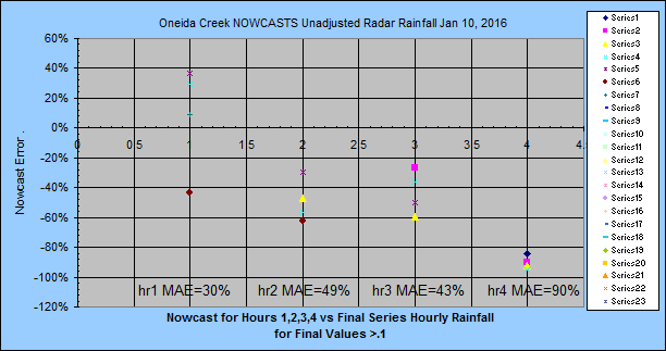
OneiNY 1 |
hh:33 |
0.1" |
S |
30% |
49% |
43% |
1 |
N0Q |
unadjusted |
|
BigCA 3 |
hh:01 |
0.1" |
S |
29% |
45% |
--- |
1 |
N0Q |
unadjusted |
|
BigCA 3 |
hh:01 |
0.1" |
S |
66% |
66% |
65% |
none |
NWS |
gage avg |
|
BigCA 4 |
hh:02 |
0.1" |
S |
24% |
64% |
62% |
1 |
N0Q |
unadjusted |
|
BigCA 4 |
hh:02 |
0.1" |
S |
52% |
49% |
58% |
none |
NWS |
gage avg |
|
AldriAL 1 |
hh:06 |
0.1" |
FS |
32% |
70% |
96% |
none |
N0Q |
unadjusted |
|
AldriAL 1 |
hh:06 |
0.1" |
FS |
31% |
81% |
100% |
1 |
N0Q |
unadjusted |
|
AldriAL 1 |
hh:06 |
0.1" |
FS |
74% |
69% |
62% |
none |
NWS |
gage avg |
|
BigCA 5 |
hh:10 |
0.1" |
S |
16% |
33% |
64% |
1 |
N0Q |
unadjusted |
|
BigCA 5 |
hh:10 |
0.1" |
S |
72% |
72% |
72% |
none |
NWS |
gage avg |
|
VillaAL 3 |
hh:07 |
0.1" |
FS |
22% |
31% |
51% |
none |
N0Q |
unadjusted |
|
VillaAL 3 |
hh:07 |
0.1" |
FS |
83% |
48% |
125% |
none |
N0Q |
G/R adj |
|
VillaAL 3 |
hh:07 |
0.1" |
FS |
59% |
53% |
48% |
none |
NWS |
gage avg |
|
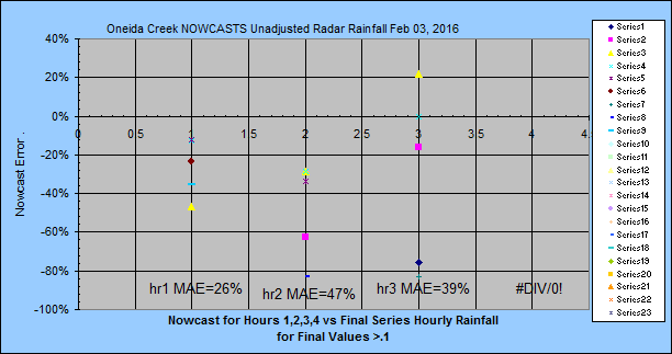
Oneida 2 |
hh:17 |
0.1" |
S |
26% |
47% |
39% |
none |
N0Q |
unadjusted |
|
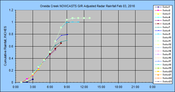
Oneida 2 |
hh:17 |
0.1" |
S |
25% |
47% |
44% |
none |
N0Q |
G/R adj |
|
Below |
are |
with |
out |
graphs |
or |
text. |
|
|
|
|
AldriAL 2 |
hh:05 |
0.1" |
T |
49% |
76% |
96% |
none |
N0Q |
unadjusted |
|
AldriAL 2 |
hh:05 |
0.1" |
T |
120% |
80% |
97% |
none |
N0Q |
G/R adj |
|
AldriAL 2 |
hh:05 |
0.1" |
T |
60% |
59% |
59% |
none |
NWS |
gage avg |
|
AldriAL 3 |
hh:10 |
0.1" |
T |
56% |
80% |
96% |
none |
N0Q |
unadjusted |
|
AldriAL 3 |
hh:10 |
0.1" |
T |
52% |
93% |
99% |
none |
N0Q |
G/R adj |
|
AldriAL 3 |
hh:10 |
0.1" |
T |
62% |
61% |
53% |
none |
NWS |
gage avg |
|
Oneida 3 |
hh:15 |
0.1" |
S |
23% |
46% |
93% |
none |
N0Q |
unadjusted |
|
AldriAL 4 |
hh:07 |
0.1" |
T |
60% |
54% |
83% |
none |
N0Q |
G/R adj |
|
Oneida 4 |
hh:07 |
0.1" |
T |
60% |
42% |
50% |
none |
N0Q |
unadjusted |
|
BigCA 6 |
hh:05 |
0.1" |
S |
36% |
71% |
91% |
1 |
N0Q |
unadjusted |
|
BigCA 6 |
hh:05 |
0.1" |
S |
27% |
56% |
86% |
1 |
N0Q |
G/R adj |
|
BigCA 6 |
hh:05 |
0.1" |
S |
63% |
66% |
76% |
none |
NWS-4 |
gage avg |
|
BigCA 7 |
hh:05 |
0.1" |
S |
22% |
41% |
68% |
1 |
N0Q |
unadjusted |
|
BigCA 7 |
hh:05 |
0.1" |
S |
45% |
54% |
71% |
1 |
N0Q |
G/R adj |
|
BigCA 7 |
hh:05 |
0.1" |
S |
50% |
45% |
51% |
none |
NWS-4 |
gage avg |
|
AldriAL 4 |
hh:06 |
0.1" |
T |
20% |
32% |
98% |
none |
N0Q |
G/R adj |
|
AldriAL 4 |
hh:06 |
0.1" |
T |
81% |
72% |
59% |
none |
NWS |
gage avg |
|
BigCA 8 |
hh:07 |
0.1" |
S |
speed/dir |
out of |
range |
none |
N0Q |
G/R adj |
|
BigCA 8 |
hh:07 |
0.1" |
S |
38% |
36% |
57% |
none |
NWS-4 |
gage avg |
|
BigCA 9 |
hh:05 |
0.1" |
S |
48% |
41% |
62% |
none |
N0Q |
G/R adj |
|
BigCA 9 |
hh:05 |
0.1" |
S |
33% |
45% |
65% |
none |
NWS-4 |
gage avg |
|
OneiNY 5 |
hh:06 |
0.1" |
T |
8% |
71% |
79% |
none |
N0Q |
G/R adj |
|
OneiNY 5 |
hh:06 |
0.1" |
T |
91% |
91% |
83% |
none |
NWS-3 |
gage avg |
|
AldriAL 5 |
hh:06 |
0.1" |
T |
60% |
83% |
135% |
none |
N0Q |
G/R adj |
|
AldriAL 5 |
hh:06 |
0.1" |
T |
52% |
51% |
60% |
none |
NWS-3 |
gage avg |
|
BigCA 10 |
hh:05 |
0.1" |
S |
59% |
17% |
61% |
none |
N0Q |
G/R adj |
|
BigCA 10 |
hh:05 |
0.1" |
S |
29% |
38% |
53% |
none |
NWS-4 |
gage avg |
|
AldriAL 6 |
hh:06 |
0.1" |
T |
31% |
64% |
64% |
none |
N0Q |
G/R adj |
|
AldriAL 6 |
hh:06 |
0.1" |
T |
32% |
51% |
75% |
none |
NWS-3 |
gage avg |
|
Fargo 1 |
hh:21 |
0.1" |
T |
66% |
64% |
91% |
none |
N0Q |
G/R adj |
|
Fargo 1 |
hh:21 |
0.1" |
T |
96% |
96% |
96% |
none |
NWS-3 |
gage avg |
|
OneiNY 6 |
hh:06 |
0.1" |
T |
53% |
79% |
100% |
none |
N0Q |
G/R adj |
|
OneiNY 6 |
hh:06 |
0.1" |
T |
76% |
82% |
91% |
none |
NWS-3 |
gage avg |
|
Fargo 2 |
hh:21 |
0.1" |
T |
9% |
54% |
100% |
none |
N0Q |
G/R adj |
|
Fargo 2 |
hh:21 |
0.1" |
T |
48% |
44% |
59% |
none |
NWS-3 |
gage avg |
|
Oneida 7 |
hh:06 |
0.1" |
T |
48% |
65% |
69% |
none |
N0Q |
G/R adj |
|
Oneida 7 |
hh:06 |
0.1" |
T |
26% |
21% |
59% |
none |
NWS-3 |
gage avg |
|
TuscaAL 1 |
hh:05 |
0.1" |
T |
33% |
65% |
72% |
none |
N0Q |
G/R adj |
|
TuscaAL 1 |
hh:05 |
0.1" |
T |
82% |
88% |
100% |
none |
NWS-3 |
gage avg |
|
OneiNY 8 |
hh:12 |
0.1" |
T |
34% |
92% |
98% |
none |
N0Q |
G/R adj |
|
OneiNY 8 |
hh:12 |
0.1" |
T |
98% |
98% |
98% |
none |
NWS-3 |
gage avg |
|
Fargo 3 |
hh:13 |
0.1" |
T |
60% |
99% |
100% |
none |
N0Q |
G/R adj |
|
Fargo 3 |
hh:13 |
0.1" |
T |
96% |
97% |
99% |
none |
NWS-3 |
gage avg |
|
DaltGA 1 |
hh:10 |
0.1" |
T |
69% |
100% |
100% |
none |
N0Q |
G/R adj |
|
DaltGA 1 |
hh:10 |
0.1" |
T |
95% |
94% |
79% |
none |
NWS-3 |
gage avg |
|
OneiNY 9 |
hh:08 |
0.1" |
T |
24% |
100% |
99% |
none |
N0Q |
G/R adj |
|
OneiNY 9 |
hh:08 |
0.1" |
T |
80% |
75% |
5% |
none |
NWS-3 |
gage avg |
|
Fargo 4 |
hh:23 |
0.1" |
SQ |
10% |
89% |
91% |
none |
N0Q |
G/R adj |
|
Fargo 4 |
hh:23 |
0.1" |
SQ |
20% |
86% |
78% |
none |
NWS-3 |
gage avg |
|
BEGIN |
+ or - |
MAE |
|
Errors |
see note |
below |
|
|
|
|
These start |
in July |
and are |
small |
Tstorms |
unlike |
the win |
ter/spring |
SQ, F |
& S above |
|
OneiNY 10 |
hh:10 |
0.1" |
SQ |
-41% |
-100% |
-100% |
none |
N0Q |
G/R adj |
|
OneiNY 10 |
hh:10 |
0.1" |
SQ |
-87% |
-87% |
-74% |
none |
NWS-3 |
gage avg |
|
OneiNY 10 |
hh:10 |
0.1" |
SQ |
-36% |
-90% |
-94% |
none |
N0Q |
G/R adj |
|
OneiNY 10 |
hh:10 |
0.1" |
SQ |
-100% |
-100% |
-61% |
none |
NWS-3 |
gage avg |
|
VillaAL 4 |
hh:07 |
0.1" |
T |
-73% |
-51% |
-100% |
3 |
NCQ |
G/R adj |
|
VillaAL 4 |
hh:07 |
0.1" |
T |
-93% |
-95% |
-97% |
none |
NWS-3 |
gage avg |
|
VillaAL 5 |
hh:07 |
0.1" |
T |
+493% |
-88% |
-100% |
3 |
NCQ |
G/R adj |
|
VillaAL 5 |
hh:07 |
0.1" |
T |
-88% |
-91% |
-95% |
none |
NWS-3 |
gage avg |
|
VillaAL 6 |
hh:11 |
0.1" |
T |
-78% |
-100% |
-99% |
3 |
NCQ |
G/R adj |
|
VillaAL 6 |
hh:11 |
0.1" |
T |
-100% |
-100% |
-100% |
none |
NWS-3 |
gage avg |
|
OneiNY 11 |
hh:10 |
0.1" |
T |
-65% |
-98% |
-100% |
none |
N0Q |
G/R adj |
|
OneiNY 11 |
hh:10 |
0.1" |
T |
-100% |
-100% |
-100% |
none |
NWS-3 |
gage avg |
|
Fargo 5 |
hh:10 |
0.1" |
T |
+-44% |
-59% |
-59% |
2 |
N0Q |
G/R adj |
|
Fargo 5 |
hh:10 |
0.1" |
T |
-97% |
-98% |
-99% |
none |
NWS-3 |
gage avg |
|
TuscaAL 2 |
hh:12 |
0.1" |
T |
+68% |
-74% |
-95% |
3 |
N0Q |
G/R adj |
|
TuscaAL 2 |
hh:12 |
0.1" |
T |
-92% |
-92% |
-76% |
none |
NWS-3 |
gage avg |
|
Aldridge 7 |
hh:12 |
0.1" |
T |
-60% |
-100% |
-100% |
3 |
N0Q |
G/R adj |
|
Aldridge 7 |
hh:12 |
0.1" |
T |
-96% |
-97% |
-98% |
none |
NWS-3 |
gage avg |
|
BurroAZ 1 |
hh:06 |
0.1" |
T |
-22% |
-59% |
+43% |
3 |
NCQ |
G/R adj |
|
BurroAZ 1 |
hh:06 |
0.1" |
T |
-96% |
-96% |
-96% |
none |
NWS-5 |
gage avg |
|
VillaAL 7 |
hh:07 |
0.1" |
T |
-100% |
-100% |
-100% |
3 |
NCQ |
G/R adj |
|
VillaAL 7 |
hh:07 |
0.1" |
T |
-100% |
-100% |
-100% |
none |
NWS-3 |
gage avg |
|
AldriAL 8 |
hh:12 |
0.1" |
T |
+6% |
-100% |
-100% |
3 |
N0Q |
G/R adj |
|
AldriAL 8 |
hh:12 |
0.1" |
T |
-95% |
-96% |
-98% |
none |
NWS-3 |
gage avg |
|
BurroAZ 2 |
hh:08 |
0.1" |
T |
+-40% |
-99% |
-100% |
3 |
NCQ |
G/R adj |
|
BurroAZ 2 |
hh:08 |
0.1" |
T |
-100% |
-100% |
-28% |
none |
NWS-2 |
gage avg |
|
BurroAZ 3 |
hh:08 |
0.1" |
T |
+-92% |
-51% |
-97% |
3 |
NCQ |
G/R adj |
|
BurroAZ 3 |
hh:08 |
0.1" |
T |
-91% |
-90% |
-84% |
none |
NWS-6 |
gage avg |
|
BurroAZ 4 |
hh:08 |
0.1" |
T |
-55% |
-86% |
-81% |
3 |
NCQ |
G/R adj |
|
BurroAZ 4 |
hh:08 |
0.1" |
T |
-100% |
-100% |
+21% |
none |
NWS-3 |
gage avg |
|
OneiNY 12 |
hh:12 |
0.1" |
T |
-20% |
-20% |
-80% |
3 |
N0Q |
G/R adj |
|
OneiNY 12 |
hh:12 |
0.1" |
T |
-96% |
-94% |
-84% |
none |
NWS-3 |
gage avg |
|
VillaAL 8 |
hh:15 |
0.1" |
T |
-85% |
-97% |
-97% |
3 |
N0Q |
G/R adj |
|
VillaAL 8 |
hh:15 |
0.1" |
T |
-93% |
-95% |
-98% |
none |
NWS-3 |
gage avg |
|
TuscaAL 3 |
hh:14 |
0.1" |
T |
-22% |
-100% |
--- |
3 |
N0Q |
G/R adj |
|
TuscaAL 3 |
hh:14 |
0.1" |
T |
-82% |
-69% |
--- |
none |
NWS-3 |
gage avg |
|
OneiNY 13 |
hh:10 |
0.1" |
T |
-43% |
-55% |
-100% |
3 |
N0Q |
G/R adj |
|
OneiNY 13 |
hh:10 |
0.1" |
T |
-84% |
-76% |
-65% |
none |
NWS-3 |
gage avg |
|
OneiNY 14 |
hh:06 |
0.1" |
T |
+87% |
-62% |
+101% |
3 |
N0Q |
G/R adj |
|
OneiNY 14 |
hh:06 |
0.1" |
T |
-87% |
-68% |
+-72% |
none |
NWS-3 |
gage avg |
|
OneiNY 15 |
hh:09 |
0.1" |
SQ |
+53% |
-74% |
-80% |
3 |
N0Q |
G/R adj |
|
OneiNY 15 |
hh:09 |
0.1" |
SQ |
-92% |
-92% |
-80% |
none |
NWS-3 |
gage avg |
|
TuscaAL 4 |
hh:06 |
0.1" |
T |
-83% |
+102% |
-88 |
3 |
N0Q |
G/R adj |
|
TuscaAL 4 |
hh:06 |
0.1" |
T |
-87% |
-87% |
-82 |
none |
NWS-3 |
gage avg |
|
BurroAZ 4 |
hh:10 |
0.1" |
T |
+-94% |
-97% |
-99% |
3 |
NCQ |
G/R adj |
|
BurroAZ 4 |
hh:10 |
0.1" |
T |
-82% |
-81% |
-65% |
none |
NWS-3 |
gage avg |
|
VillaAL 9 |
hh:08 |
0.1" |
T |
+-45% |
-98% |
-100% |
3 |
N0Q |
G/R adj |
|
VillaAL 9 |
hh:08 |
0.1" |
T |
-78% |
-90% |
-95% |
none |
NWS-3 |
gage avg |
|
Aldridge 8 |
hh:05 |
0.1" |
T |
-13% |
-97% |
-96% |
3 |
N0Q |
G/R adj |
|
Aldridge 8 |
hh:05 |
0.1" |
T |
-85% |
-89% |
-95% |
none |
NWS-3 |
gage avg |
|
TuscaAL 5 |
hh:06 |
0.1" |
T |
-+57% |
-90% |
-80 |
3 |
N0Q |
G/R adj |
|
TuscaAL 5 |
hh:06 |
0.1" |
T |
-56% |
-75% |
-84 |
none |
NWS-3 |
gage avg |
|
OneiNY 16 |
hh:10 |
0.1" |
T |
-+16% |
-+19% |
+39% |
3 |
N0Q |
G/R adj |
|
OneiNY 16 |
hh:10 |
0.1" |
T |
-+56% |
-+52% |
-50% |
none |
NWS-3 |
gage avg |
|
Aldridge 9 |
hh:05 |
0.1" |
SQ/T |
+-59% |
-+84% |
-85% |
3 |
N0Q |
G/R adj |
|
Aldridge 9 |
hh:05 |
0.1" |
SQ/T |
-86% |
-90% |
-95% |
none |
NWS-3 |
gage avg |
|
BurroAZ 5 |
hh:10 |
0.1" |
T |
-+32% |
-+73% |
-+48% |
3 |
NCQ |
G/R adj |
|
BurroAZ 5 |
hh:10 |
0.1" |
T |
-70% |
-78% |
-86% |
none |
NWS-3 |
gage avg |
|
Fargo 6 |
hh:11 |
0.1" |
T |
-+64% |
-91% |
-99% |
2 |
N0Q |
G/R adj |
|
Fargo 6 |
hh:11 |
0.1" |
T |
-31% |
-50% |
-75% |
none |
NWS-3 |
gage avg |
|
Aldridge 10 |
hh:05 |
0.1" |
T |
-66% |
-86% |
-100% |
3 |
N0Q |
G/R adj |
|
Aldridge 10 |
hh:05 |
0.1" |
T |
-100% |
-100% |
-100% |
none |
NWS-3 |
gage avg |
|
DaltGA 2 |
hh:06 |
0.1" |
T |
+300% |
-36% |
-61% |
none |
N0Q |
G/R adj |
|
DaltGA 2 |
hh:06 |
0.1" |
T |
-70% |
-89% |
-100% |
none |
NWS-3 |
gage avg |
|
Fargo 7 |
hh:11 |
0.1" |
T |
-64% |
-81% |
-100% |
3 |
N0Q |
G/R adj |
|
Fargo 7 |
hh:11 |
0.1" |
T |
+232% |
+40% |
-32% |
none |
NWS-3 |
gage avg |
|
Fargo 8 |
hh:11 |
0.1" |
T |
+32% |
-96% |
-100% |
3 |
N0Q |
G/R adj |
|
Fargo 8 |
hh:11 |
0.1" |
T |
-34% |
-52% |
-76% |
none |
NWS-3 |
gage avg |
|
OneiNY 17 |
hh:10 |
0.1" |
T |
+9% |
+15% |
+123% |
3 |
N0Q |
G/R adj |
|
OneiNY 17 |
hh:10 |
0.1" |
T |
+8% |
-21% |
-70% |
none |
NWS-3 |
gage avg |
|
Fargo 9 |
hh:07 |
0.1" |
T |
-14% |
+3% |
-3% |
3 |
N0Q |
G/R adj |
|
Fargo 9 |
hh:07 |
0.1" |
T |
-60% |
-71% |
-85% |
none |
NWS-3 |
gage avg |
|
BigCA 11 |
hh:05 |
0.1" |
OS |
-41% |
-92% |
-100% |
none |
N0Q |
G/R adj |
|
BigCA 11 |
hh:05 |
0.1" |
OS |
+-41% |
+-27% |
-40% |
none |
NWS-4 |
gage avg |
|
|
|
|
|
|
|
|
|
|
|
****************** ONLY RAINFALL > 0.8 in/hr ****************************
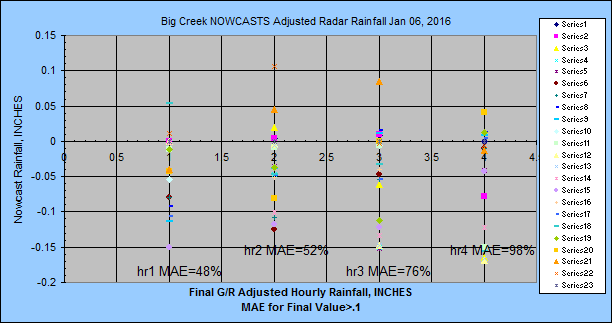
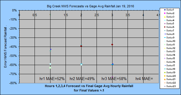
Table values above are for final rainfall greater than 0.1 inch over the hour.
Ok, let's up the ante. I just read that rainfall above 0.8 in/hr have zero
chance of being usable 1 hour out.
Values below are only for predicted OR final rainfall greater than 0.8 inches.
Begin Aug 2016.
|
Basin Run |
Start
Time |
Error Sources |
Storm
Type |
HR1 |
HR2 |
HR3 |
Adjust
Type |
Source |
Final Series |
Final Rainfall |
|
VillaAL 8 |
hh:15 |
growth |
T |
-85% |
-97% |
-97% |
3 |
NCQ |
G/R adj |
1.32 |
|
VillaAL 8 |
hh:15 |
|
T |
-93% |
-95% |
-98% |
none |
NWS-3 |
gage avg |
0.68 |
|
BurroAZ5 |
hh:10 |
G/R |
T |
+259% |
-94% |
-99% |
3 |
NCQ |
G/R adj |
0.48 |
|
BurroAZ5 |
hh:10 |
1.1 v .3 |
T |
-83% |
-94% |
-97% |
none |
NWS-3 |
gage avg |
0.48 |
|
AldrAL11 |
01:08 |
|
T |
-27% |
-99% |
--- |
3 |
N0Q |
G/R adj |
0.84 |
|
AldrAL11 |
01:08 |
|
T |
-78% |
-84% |
--- |
none |
NWS-3 |
gage avg |
0.43 |
|
AldrAL11 |
02:08 |
g/r |
T |
-46% |
-30% |
-57% |
3 |
N0Q |
G/R adj |
0.80 |
|
AldrAL11 |
02:08 |
|
T |
-83% |
-88% |
-94% |
none |
NWS-3 |
gage avg |
0.58 |
|
VillaAL9 |
hh:12 |
growth |
T |
-99% |
-100% |
-100% |
3 |
NCQ |
G/R adj |
0.80 |
|
VillaAL9 |
hh:12 |
|
T |
--- |
--- |
--- |
none |
NWS-3 |
gage avg |
0.00 |
|
NashTN1 |
hh:07 |
growth |
T |
-62% |
-100% |
-100% |
3 |
N0Q |
G/R adj |
0.84 |
|
NashTN1 |
hh:07 |
|
T |
-97 |
-97 |
-97 |
none |
NWS-3 |
gage avg |
0.55 |
|
HousTX1 |
hh:12 |
growth |
T |
-42% |
-100% |
-100% |
3 |
N0Q |
G/R adj |
2.01 |
|
HousTX1 |
hh:12 |
|
T |
-94 |
-93 |
-81 |
none |
NWS-3 |
gage avg |
0.77 |
|
DaltGA2 |
hh:07 |
g & d |
T |
+72% |
-100% |
-100% |
3 |
N0Q |
G/R adj |
0.51 |
|
DaltGA2 |
hh:07 |
|
T |
-87 |
-91 |
-95 |
none |
NWS-3 |
gage avg |
0.14 |
|
VillaAL10 |
hh:08 |
decay |
T |
+5800% |
630% |
-100% |
3 |
NCQ |
G/R adj |
0.03 |
|
VillaAL10 |
hh:08 |
|
T |
-99% |
-97% |
-96% |
none |
NWS-3 |
gage avg |
0.03 |
|
VillaAL10 |
hh:08 |
|
T |
-100% |
-100% |
-100% |
none |
HRRR |
gage avg |
0.03 |
|
VillaAL11 |
hh:10 |
|
T |
0% |
0% |
0% |
3 |
NCQ |
G/R adj |
0.01 |
|
VillaAL11 |
hh:10 |
|
T |
+300% |
+700% |
+1000% |
none |
NWS-3 |
gage avg |
0.01 |
|
VillaAL11 |
hh:10 |
|
T |
+9200% |
0% |
0% |
none |
HRRR |
gage avg |
0.01 |
|
BurroAZ6 |
hh:06 |
growth |
T |
-60% |
-83% |
-99% |
3 |
NCQ |
G/R adj |
0.79 |
|
BurroAZ6 |
hh:06 |
|
T |
-96% |
-98% |
-100% |
none |
NWS-3 |
gage avg |
0.79 |
|
BurroAZ6 |
hh:06 |
|
T |
-99% |
-84% |
-84% |
none |
HRRR |
gage avg |
0.79 |
|
HousTX2 |
hh:09 |
|
T |
+2638% |
+72% |
-99% |
none |
HRRR |
gage avg |
0.05 |
|
VillaAL12 |
hh:12 |
azmith |
T |
-100% |
-91% |
-93% |
3 |
NCQ |
G/R adj |
1.08 |
|
VillaAL12 |
hh:12 |
|
T |
-88% |
-94% |
-97% |
none |
NWS-3 |
G/R adj |
1.08 |
|
VillaAL12 |
hh:12 |
|
T |
-98% |
-100% |
-100% |
none |
HRRR |
G/R adj |
1.08 |
|
HousTX2 |
hh:10 |
|
|
-90% |
-99% |
-100% |
3 |
N0Q |
G/R adj |
1.30 |
|
HousTX2 |
hh:10 |
|
|
-81% |
-100% |
-100% |
3 |
N0Q |
G/R adj |
0.47 |
|
HousTX2 |
hh:10 |
|
|
-55% |
-93% |
-99% |
3 |
N0Q |
G/R adj |
2.50 |
|
HousTX2 |
hh:10 |
|
|
+16% |
-94% |
-100% |
3 |
N0Q |
G/R adj |
1.31 |
|
HousTX2 |
hh:10 |
|
|
-93% |
-95% |
-97% |
none |
NWS-3 |
G/R adj |
1.83 |
|
HousTX2 |
hh:10 |
|
|
-92% |
-94% |
-97% |
none |
NWS-3 |
G/R adj |
1.56 |
|
HousTX2 |
hh:10 |
|
|
-70% |
-79% |
-89% |
none |
NWS-3 |
G/R adj |
1.09 |
|
HousTX2 |
hh:10 |
|
|
-60% |
-71% |
-85% |
none |
NWS-3 |
G/R adj |
0.79 |
|
HousTX2 |
hh:10 |
|
|
-94% |
-98% |
-100% |
none |
HRRR |
G/R adj |
2.08 |
|
HousTX2 |
hh:10 |
|
|
-16% |
+55% |
-84% |
none |
HRRR |
G/R adj |
1.02 |
|
HousTX2 |
hh:10 |
|
|
-56% |
--- |
--- |
none |
HRRR |
G/R adj |
2.26 |
|
HousTX2 |
hh:10 |
|
|
-45% |
-48% |
--- |
none |
HRRR |
G/R adj |
1.07 |
|
TuscaAL6 |
hh:12 |
|
|
+32100% |
+7900% |
+9600% |
none |
HRRR |
G/R adj |
0.004 |
|
NashTN2 |
hh:06 |
|
|
-100% |
-100% |
+5734% |
none |
HRRR |
G/R adj |
0.03 |
|
HousTX3 |
hh:10 |
|
H |
-55% |
-97% |
-100% |
3 |
N0Q |
G/R adj |
1.48 |
|
HousTX3 |
hh:10 |
|
H |
+46% |
-69% |
-85% |
none |
NWS-3 |
G/R adj |
1.15 |
|
HousTX3 |
hh:10 |
|
H |
+226% |
+137% |
+12% |
none |
NWS-3 |
G/R adj |
0.35 |
|
HousTX3 |
hh:10 |
|
H |
+46% |
+789% |
+345% |
none |
NWS-3 |
G/R adj |
0.09 |
|
HousTX3 |
hh:10 |
|
H |
+1122% |
+2051% |
+976% |
none |
NWS-3 |
G/R adj |
0.09 |
|
HousTX3 |
hh:10 |
|
H |
+2857% |
+1487% |
+694% |
none |
NWS-3 |
G/R adj |
0.05 |
|
HousTX3 |
hh:10 |
|
H |
+2083% |
+958% |
+429% |
none |
NWS-3 |
G/R adj |
0.08 |
|
HousTX3 |
hh:10 |
|
H |
+1355% |
+14495 |
+7199% |
none |
NWS-3 |
G/R adj |
0.006 |
|
HousTX3 |
hh:10 |
|
H |
+840% |
+246% |
-313% |
none |
HRRR |
G/R adj |
0.17 |
|
HousTX3 |
hh:10 |
|
H |
-32% |
-15% |
-73% |
none |
HRRR |
G/R adj |
1.29 |
|
HousTX3 |
hh:10 |
|
H |
+1293% |
+1200% |
+1167% |
none |
HRRR |
G/R adj |
0.09 |
|
HousTX3 |
hh:10 |
|
H |
+1133% |
+951% |
+250% |
none |
HRRR |
G/R adj |
0.18 |
|
HousTX3 |
hh:10 |
|
H |
+9414% |
+4798% |
+4054% |
none |
HRRR |
G/R adj |
0.03 |
|
HousTX3 |
hh:10 |
|
H |
+12121% |
+5677% |
+5332% |
none |
HRRR |
G/R adj |
0.01 |
|
HousTX3 |
hh:10 |
|
H |
+118108 |
+36322 |
+26062 |
none |
HRRR |
G/R adj |
0.003 |
|
HousTX3 |
hh:10 |
|
H |
1331900 |
+61100 |
301767 |
none |
HRRR |
G/R adj |
.00009 |
|
HousTX3 |
hh:10 |
|
H |
+19970% |
+14495 |
+7199% |
none |
NWS-3 |
G/R adj |
0.006 |
|
HousTX3 |
hh:10 |
|
H |
+2560% |
+1835% |
+867% |
none |
NWS-3 |
G/R adj |
0.034 |
|
HousTX3 |
hh:10 |
|
H |
+273% |
+172% |
+36% |
none |
NWS-3 |
G/R adj |
0.24 |
|
HousTX3 |
hh:10 |
|
H |
+497% |
+334% |
+117% |
none |
NWS-3 |
G/R adj |
0.15 |
|
HousTX3 |
hh:10 |
|
H |
+1855% |
+1321% |
+611% |
none |
NWS-3 |
G/R adj |
0.047 |
|
HousTX3 |
hh:10 |
|
H |
+15876% |
+11518 |
+5709% |
none |
NWS-3 |
G/R adj |
0.006 |
|
HousTX3 |
hh:10 |
|
H |
+2594% |
+31984 |
+1337% |
none |
HRRR |
G/R adj |
0.012 |
|
HousTX3 |
hh:10 |
|
H |
+54% |
+1047% |
+3068% |
none |
HRRR |
G/R adj |
0.052 |
|
HousTX3 |
hh:10 |
|
H |
-98% |
+316% |
+530% |
none |
HRRR |
G/R adj |
0.16 |
|
HousTX3 |
hh:10 |
azim |
H |
-15% |
-100% |
-100% |
3 |
N0Q |
G/R adj |
1.90 |
|
HousTX3 |
hh:10 |
|
H |
-34% |
-84% |
-100% |
3 |
N0Q |
G/R adj |
1.50 |
|
HousTX3 |
hh:10 |
|
H |
-50% |
-74% |
-73% |
3 |
N0Q |
G/R adj |
1.06 |
|
HousTX3 |
hh:10 |
|
H |
-62% |
-89% |
-100% |
3 |
N0Q |
G/R adj |
2.18 |
|
HousTX3 |
hh:10 |
|
H |
+43% |
-27% |
-97% |
3 |
N0Q |
G/R adj |
1.12 |
|
HousTX3 |
hh:10 |
|
H |
-36% |
-95% |
-81% |
3 |
N0Q |
G/R adj |
1.17 |
|
HousTX3 |
hh:10 |
|
H |
-56% |
-76% |
-98% |
3 |
N0Q |
G/R adj |
1.53 |
|
HousTX3 |
hh:10 |
|
H |
+67% |
+22% |
-39% |
none |
NWS-3 |
G/R adj |
1.25 |
|
HousTX3 |
hh:10 |
|
H |
+24226 |
+17590 |
+8745% |
none |
NWS-3 |
G/R adj |
0.004 |
|
HousTX3 |
hh:10 |
|
H |
+2091% |
+1493% |
+697% |
none |
NWS-3 |
G/R adj |
0.10 |
|
HousTX3 |
hh:10 |
|
H |
+308% |
+197% |
+48% |
none |
NWS-3 |
G/R adj |
0.51 |
|
HousTX3 |
hh:10 |
|
H |
+47% |
+7% |
-46% |
none |
NWS-3 |
G/R adj |
1.41 |
|
HousTX3 |
hh:10 |
|
H |
+117% |
+103% |
+2% |
none |
NWS-3 |
G/R adj |
0.74 |
|
HousTX3 |
hh:10 |
|
H |
+141% |
+76% |
+13% |
none |
NWS-3 |
G/R adj |
0.67 |
|
HousTX3 |
hh:10 |
|
H |
+52% |
+11% |
-45% |
none |
NWS-3 |
G/R adj |
1.04 |
|
HousTX3 |
hh:10 |
|
H |
+3% |
-25% |
-63% |
none |
NWS-3 |
G/R adj |
1.54 |
|
HousTX3 |
hh:10 |
|
H |
+20% |
-12% |
-56% |
none |
NWS-3 |
G/R adj |
1.31 |
|
HousTX3 |
hh:10 |
|
H |
+250% |
+155% |
-14% |
none |
NWS-3 |
G/R adj |
0.54 |
|
HousTX3 |
hh:10 |
|
H |
-51% |
-26 |
-5% |
none |
HRRR |
G/R adj |
1.59 |
|
HousTX3 |
hh:10 |
|
H |
+54237% |
+81100 |
104067 |
none |
HRRR |
G/R adj |
1.60 |
|
HousTX3 |
hh:10 |
|
H |
+65951% |
+36847 |
+43456 |
none |
HRRR |
G/R adj |
0.034 |
|
HousTX3 |
hh:10 |
|
H |
+6102% |
+2979% |
+61% |
none |
HRRR |
G/R adj |
0.41 |
|
HousTX3 |
hh:10 |
|
H |
+513% |
-61% |
+141% |
none |
HRRR |
G/R adj |
1.93 |
|
HousTX3 |
hh:10 |
|
H |
+35% |
+46% |
+41% |
none |
HRRR |
G/R adj |
0.81 |
|
HousTX3 |
hh:10 |
|
H |
+25% |
+34% |
-25% |
none |
HRRR |
G/R adj |
1.35 |
|
HousTX3 |
hh:10 |
|
H |
-26% |
-53 % |
+99% |
none |
HRRR |
G/R adj |
1.02 |
|
HousTX3 |
hh:10 |
|
H |
+2688% |
+1485% |
+156% |
none |
HRRR |
G/R adj |
0.08 |
|
HousTX3 |
hh:10 |
|
H |
-52% |
+101% |
+26% |
none |
HRRR |
G/R adj |
0.66 |
|
HousTX3 |
hh:10 |
|
H |
-59% |
-43% |
-2% |
none |
HRRR |
G/R adj |
1.27 |
|
HousTX3 |
hh:10 |
|
H |
+48% |
-91% |
+93% |
none |
HRRR |
G/R adj |
1.14 |
|
NashTN3 |
hh:07 |
|
TD |
-19% |
-57% |
-54% |
3 |
N0Q |
G/R adj |
1.02 |
|
NashTN3 |
hh:07 |
|
TD |
-7% |
-48% |
-74% |
3 |
N0Q |
G/R adj |
1.73 |
|
NashTN3 |
hh:07 |
|
TD |
-56% |
-67% |
-73% |
3 |
N0Q |
G/R adj |
1.74 |
|
NashTN3 |
hh:07 |
|
TD |
+14% |
-17% |
-58% |
none |
NWS-3 |
gage avg |
0.92 |
|
NashTN3 |
hh:07 |
|
TD |
-47% |
-46% |
-73% |
none |
NWS-3 |
gage avg |
1.42 |
|
NashTN3 |
hh:07 |
|
TD |
-34% |
-52% |
-66% |
none |
NWS-3 |
gage avg |
1.12 |
|
NashTN3 |
hh:07 |
|
TD |
+83% |
+187% |
+8% |
none |
HRRR |
G/R adj |
0.46 |
|
NashTN3 |
hh:07 |
|
TD |
+54% |
+26% |
+115% |
none |
HRRR |
G/R adj |
0.50 |
|
NashTN3 |
hh:07 |
|
TD |
+88% |
+83% |
+47% |
none |
HRRR |
G/R adj |
0.92 |
|
NashTN3 |
hh:07 |
|
TD |
+68% |
+69% |
+57% |
none |
HRRR |
G/R adj |
1.42 |
|
NashTN3 |
hh:07 |
|
TD |
+83% |
+26% |
+55% |
none |
HRRR |
G/R adj |
1.12 |
|
VillaAL13 |
hh:09 |
azim |
TD |
-51% |
-91% |
-85 |
3 |
NCQ |
G/R adj |
1.82 |
|
VillaAL13 |
hh:09 |
|
TD |
-84% |
-88% |
-94% |
none |
NWS-3 |
G/R adj |
1.82 |
|
VillaAL13 |
hh:09 |
|
TD |
-95% |
-59% |
-29% |
none |
HRRR |
G/R adj |
1.51 |
|
NashTN4 |
hh:07 |
|
TD |
-62% |
-87% |
-34% |
3 |
N0Q |
G/R adj |
1.43 |
|
NashTN4 |
hh:07 |
|
TD |
-99% |
-97% |
-96% |
none |
NWS-3 |
gage avg |
1.40 |
|
NashTN4 |
hh:07 |
|
TD |
-100% |
-100% |
-100% |
none |
HRRR |
G/R adj |
1.40 |
|
TuscaAL1 |
hh:06 |
|
TD |
-68% |
+15% |
-100% |
3 |
N0Q |
G/R adj |
0.99 |
|
TuscaAL1 |
hh:06 |
|
TD |
-46% |
-61% |
-80% |
none |
NWS-3 |
gage avg |
0.89 |
|
TuscaAL1 |
hh:06 |
|
TD |
-79% |
-85% |
-84% |
none |
HRRR |
G/R adj |
0.99 |
|
TuscaAL2 |
hh:09 |
|
TD |
-55% |
-78% |
-100% |
3 |
N0Q |
G/R adj |
0.87 |
|
TuscaAL2 |
hh:09 |
|
TD |
-59% |
-70% |
-85% |
none |
NWS-3 |
gage avg |
0.83 |
|
TuscaAL2 |
hh:09 |
|
TD |
-93% |
-68% |
-93% |
none |
HRRR |
G/R adj |
0.87 |
|
HousTX4 |
hh:09 |
azim |
TD |
-84% |
-48% |
+33% |
3 |
N0Q |
G/R adj |
1.10 |
|
HousTX4 |
hh:09 |
|
TD |
-100% |
-86% |
-77% |
none |
NWS-3 |
gage avg |
1.43 |
|
HousTX4 |
hh:09 |
|
TD |
-99% |
-100% |
-96% |
none |
HRRR |
G/R adj |
1.43 |
|
DaltGA3 |
hh:05 |
decay |
SQ |
+2,257% |
+20% |
-100% |
3 |
N0Q |
G/R adj |
0.13 |
|
AldrAL12 |
hh:08 |
decay |
SQ |
+200% |
+761% |
-100% |
3 |
N0Q |
G/R adj |
0.15 |
|
VillaAL14 |
hh:09 |
speed |
SQ |
+41% |
-92% |
-100 |
3 |
NCQ |
G/R adj |
1.17 |
|
VillaAL14 |
hh:09 |
|
SQ |
-80% |
-86% |
-93% |
none |
NWS-3 |
G/R adj |
1.17 |
|
VillaAL14 |
hh:09 |
|
SQ |
-100% |
-45% |
-78% |
none |
HRRR |
G/R adj |
1.17 |
|
AldrAL13 |
hh:08 |
growth |
T |
+29% |
-100% |
-97% |
3 |
N0Q |
G/R adj |
0.86 |
|
AldrAL13 |
hh:08 |
|
T |
-88% |
-92% |
-96% |
none |
NWS-3 |
G/R adj |
0.86 |
|
AldrAL13 |
hh:08 |
|
T |
-45% |
-100% |
-87% |
none |
HRRR |
G/R adj |
0.86 |
|
TuscaAL3 |
hh:09 |
growth |
T |
+24% |
-100% |
-100% |
3 |
N0Q |
G/R adj |
0.87 |
|
TuscaAL3 |
hh:09 |
|
T |
-87% |
-90% |
-90% |
none |
NWS-3 |
gage avg |
0.87 |
|
TuscaAL3 |
hh:09 |
|
T |
-99% |
-100% |
-100% |
none |
HRRR |
G/R adj |
0.87 |
|
SlateKS1 |
hh:07 |
speed |
SQ |
+77% |
-52% |
-100% |
3 |
N0Q |
G/R adj |
0.61 |
|
FloGag1-1 |
hh:08 |
azim |
H |
-86% |
-54% |
-100% |
3 |
N0Q |
G/R adj |
1.13 |
|
FloGag1-1 |
hh:08 |
|
H |
-66% |
-39% |
-39% |
none |
NWS-0 |
G/R adj |
1.13 |
|
FloGag1-1 |
hh:08 |
|
H |
-98% |
-93% |
-78% |
none |
HRRR |
G/R adj |
1.13 |
|
FloGag1-2 |
hh:08 |
azim |
H |
-40% |
-78% |
-99% |
3 |
N0Q |
G/R adj |
1.07 |
|
FloGag1-2 |
hh:08 |
|
H |
-62% |
-59% |
-33% |
none |
NWS-0 |
G/R adj |
1.07 |
|
FloGag1-2 |
hh:08 |
|
H |
-66% |
-68% |
-84% |
none |
HRRR |
G/R adj |
1.07 |
|
FloGag1-3 |
hh:08 |
azim |
H |
-85% |
-40% |
-90% |
3 |
N0Q |
G/R adj |
1.18 |
|
FloGag1-3 |
hh:08 |
|
H |
-66% |
-63% |
-63% |
none |
NWS-0 |
G/R adj |
1.18 |
|
FloGag1-3 |
hh:08 |
|
H |
+17% |
-17% |
-98% |
none |
HRRR |
G/R adj |
1.18 |
|
FloGag1-4 |
hh:08 |
azim |
H |
-80% |
-97% |
-96% |
3 |
N0Q |
G/R adj |
1.91 |
|
FloGag1-4 |
hh:08 |
|
H |
-68% |
-77% |
-77% |
none |
NWS-0 |
G/R adj |
1.91 |
|
FloGag1-4 |
hh:08 |
|
H |
-55% |
-42% |
-48% |
none |
HRRR |
G/R adj |
1.91 |
|
FloGag1-5 |
hh:08 |
azim |
H |
+535% |
-73% |
-79% |
3 |
N0Q |
G/R adj |
0.88 |
|
FloGag1-5 |
hh:08 |
|
H |
-52% |
-48% |
-48% |
none |
NWS-0 |
G/R adj |
0.88 |
|
FloGag1-5 |
hh:08 |
|
H |
-87% |
-6% |
-72% |
none |
HRRR |
G/R adj |
0.88 |
|
FloGag2-1 |
hh:08 |
azim |
H |
-67% |
-74% |
-100% |
3 |
N0Q |
G/R adj |
1.57 |
|
FloGag2-1 |
hh:08 |
|
H |
-53% |
-59% |
-59% |
none |
NWS-0 |
G/R adj |
1.57 |
|
FloGag2-1 |
hh:08 |
|
H |
-98% |
-94% |
-85% |
none |
HRRR |
G/R adj |
1.57 |
|
FloGag2-2 |
hh:08 |
growth |
H |
-38% |
-85% |
-100% |
3 |
N0Q |
G/R adj |
0.88 |
|
FloGag2-2 |
hh:08 |
|
H |
-63% |
-59% |
-57% |
none |
NWS-0 |
G/R adj |
0.88 |
|
FloGag2-2 |
hh:08 |
|
H |
-100% |
-100% |
-97% |
none |
HRRR |
G/R adj |
0.88 |
|
HousTX5 |
hh:07 |
growth |
T |
+4% |
-48% |
-100% |
3 |
N0Q |
G/R adj |
0.83 |
|
HousTX5 |
hh:07 |
|
T |
-51% |
-64% |
-82% |
none |
NWS-3 |
gage avg |
0.43 |
|
HousTX5 |
hh:07 |
|
T |
-38% |
+195% |
+50% |
none |
HRRR |
G/R adj |
0.43 |
|
DaltGA4 |
hh:08 |
growth |
T |
-35% |
-48% |
-97% |
3 |
N0Q |
G/R adj |
1.26 |
|
DaltGA4 |
hh:08 |
|
T |
-87 |
-91 |
-95 |
none |
NWS-3 |
gage avg |
1.02 |
|
DaltGA4 |
hh:08 |
|
T |
-91% |
+96% |
+97% |
none |
HRRR |
gage avg |
1.02 |
|
HousTX6 |
hh:07 |
ratio |
SQ |
-45% |
-62% |
-100% |
3 |
N0Q |
G/R adj |
1.36 |
|
HousTX6 |
hh:07 |
|
SQ |
-52% |
-65% |
-82% |
none |
NWS-3 |
gage avg |
1.19 |
|
HousTX6 |
hh:07 |
|
SQ |
-67% |
-45% |
-80% |
none |
HRRR |
G/R adj |
1.19 |
|
NashTN5 |
hh:06 |
ratio |
SQ |
-67% |
-87% |
-95% |
3 |
N0Q |
G/R adj |
1.46 |
|
NashTN5 |
hh:06 |
|
SQ |
-66% |
-75% |
-88% |
none |
NWS-3 |
gage avg |
1.70 |
|
NashTN5 |
hh:06 |
|
SQ |
-83% |
-98% |
-82% |
none |
HRRR |
G/R adj |
1.70 |
|
HousTX7 |
hh:07 |
growth |
SQ |
-26% |
-92% |
-98% |
3 |
N0Q |
G/R adj |
1.29 |
|
HousTX7 |
hh:07 |
|
SQ |
-20% |
-41% |
-71% |
none |
NWS-3 |
gage avg |
1.04 |
|
HousTX7 |
hh:07 |
|
SQ |
-67% |
-44% |
-80% |
none |
HRRR |
G/R adj |
1.20 |
|
AldrAL14 |
hh:07 |
growth |
T |
-57% |
-100% |
-100% |
3 |
N0Q |
G/R adj |
1.48 |
|
AldrAL14 |
hh:07 |
& ratio |
T |
-94% |
-96% |
-98% |
none |
NWS-3 |
G/R adj |
1.48 |
|
AldrAL14 |
hh:07 |
|
T |
-100% |
-100% |
-98% |
none |
HRRR |
G/R adj |
1.48 |
|
NashTN6 |
hh:05 |
ratio |
SQ |
-61% |
-84% |
-70% |
3 |
N0Q |
G/R adj |
0.89 |
|
NashTN6 |
hh:05 |
|
SQ |
-80% |
-85% |
-90% |
none |
NWS-3 |
gage avg |
0.89 |
|
NashTN6 |
hh:05 |
|
SQ |
-97% |
-93% |
-93% |
none |
HRRR |
G/R adj |
0.89 |
|
VillaAL15 |
hh:09 |
growth |
SQ |
-16% |
-78% |
-92 |
3 |
NCQ |
G/R adj |
1.16 |
|
VillaAL15 |
hh:09 |
& ratio |
SQ |
-67% |
-76% |
-88% |
none |
NWS-3 |
G/R adj |
1.16 |
|
VillaAL15 |
hh:09 |
& count |
SQ |
-71% |
-86% |
-83% |
none |
HRRR |
G/R adj |
1.16 |
|
VillaAL16 |
hh:07 |
growth |
SQ |
-30% |
-51% |
-97 |
3 |
NCQ |
G/R adj |
0.96 |
|
VillaAL16 |
hh:07 |
|
SQ |
-95% |
-96% |
-98% |
none |
NWS-3 |
G/R adj |
0.96 |
|
VillaAL16 |
hh:07 |
|
SQ |
-100% |
-100% |
-100% |
none |
HRRR |
G/R adj |
0.96 |
|
TuscaAL4 |
hh:07 |
growth |
T |
-51% |
-73% |
-92% |
3 |
N0Q |
G/R adj |
0.86 |
|
TuscaAL4 |
hh:07 |
&ratio |
T |
-26% |
-46% |
-73% |
none |
NWS-3 |
gage avg |
0.65 |
|
TuscaAL4 |
hh:07 |
|
T |
-94% |
-89% |
-99% |
none |
HRRR |
G/R adj |
0.65 |
|
TuscaAL5 |
hh:06 |
growth |
S |
-58% |
-90% |
---% |
3 |
N0Q |
G/R adj |
1.38 |
|
TuscaAL5 |
hh:06 |
|
S |
-67% |
-76% |
---% |
none |
NWS-3 |
gage avg |
1.25 |
|
TuscaAL5 |
hh:06 |
|
S |
-100% |
-100% |
---% |
none |
HRRR |
G/R adj |
1.25 |
|
DaltGA5 |
hh:12 |
ratio & |
T |
-40% |
-76% |
-95% |
3 |
N0Q |
G/R adj |
1.11 |
|
DaltGA5 |
hh:12 |
growth |
T |
+35 |
-2 |
-50 |
none |
NWS-3 |
gage avg |
0.95 |
|
DaltGA5 |
hh:12 |
|
T |
-92% |
-94% |
-96% |
none |
HRRR |
gage avg |
0.95 |
|
TuscaAL6 |
hh:10 |
growth |
T |
+2% |
-94% |
-100% |
3 |
N0Q |
G/R adj |
1.18 |
|
TuscaAL6 |
hh:10 |
|
T |
-77% |
-84% |
-92% |
none |
NWS-3 |
gage avg |
1.32 |
|
TuscaAL6 |
hh:10 |
|
T |
-90% |
-94% |
-96% |
none |
HRRR |
G/R adj |
1.32 |
|
DaltGA5 |
hh:12 |
growth |
T |
-19% |
-48% |
-92% |
3 |
N0Q |
G/R adj |
0.96 |
|
DaltGA5 |
hh:12 |
|
T |
+37 |
0 |
-50 |
none |
NWS-3 |
gage avg |
0.93 |
|
DaltGA5 |
hh:12 |
|
T |
-55% |
-81% |
-55% |
none |
HRRR |
gage avg |
0.93 |
|
WarrVA1 |
hh:10 |
ratio |
TS |
-90% |
-94% |
-71% |
3 |
N0Q |
G/R adj |
1.06 |
|
WarrVA1 |
hh:10 |
|
TS |
-92 |
-92 |
-92 |
none |
NWS-3 |
gage avg |
1.06 |
|
WarrVA1 |
hh:10 |
|
TS |
-99% |
-99% |
-99% |
none |
HRRR |
gage avg |
1.06 |
|
VillaAL17 |
hh:07 |
azimth |
SQ |
-100% |
-71% |
-61 |
3 |
NCQ |
G/R adj |
2.19 |
|
VillaAL17 |
hh:07 |
|
SQ |
-95% |
-91% |
-97% |
none |
NWS-3 |
G/R adj |
2.19 |
|
VillaAL17 |
hh:07 |
|
SQ |
-100% |
-100% |
-100% |
none |
HRRR |
G/R adj |
2.19 |
|
HousTX8 |
hh:07 |
growth |
SQ |
+9% |
-96% |
+99% |
3 |
N0Q |
G/R adj |
1.30 |
|
HousTX8 |
hh:07 |
|
SQ |
+15% |
-17% |
-58% |
none |
NWS-3 |
gage avg |
0.96 |
|
HousTX8 |
hh:07 |
|
SQ |
-97% |
-99% |
-100% |
none |
HRRR |
G/R adj |
0.96 |
|
|
|
|
|
|
|
|
|
|
|
|
Note:
Update Jul 12, 2016 a lot more often than not, errors less than 100% are event under estimates
(alarm bells), 100% means 0 forecast, and greater than 100% means most event
predictions over by AT LEAST 100%. It's event mean UNSIGNED error
remember. I should probably add a sign to them as - under forecast, + over
forecast. Signed unsigned errors. Hey science aint science
till it's enginerring.
Storm types: S(stratiform), T(thunder),
F(front), SQ(squall line), O(orographic), H(hurricane), TD(tropical depression),
TS(tropical storm)
NWS=National Weather Service average 6 hour
QPF provided in equal hourly values.
NWS-2=Distribution type
2,
Dallas 4 hour.
NWS-3=Distribution type 3,
Vegas 5 hour.
(Type-3 distribution: Hr1 is
3*6hrAvg, Hr2 is 2*6hrAvg, Hr3 is
1*6hrAvg, 0, 0. 0 and future 6 hour periods use the 5-minute distribution
over the 6 hours.)
NWS-4=Distribution type 4, California 6 hour.
(Type-4 distribution: Hr1 is 2*6hrAvg, Hr2 is 1.6*6hrAvg, Hr3 is
1.2*6hrAvg, 0.8, 0.4. 0 and future 6 hour periods use the 5-minute distribution
over the 6 hours.)
NWS-5=Distribution type 5,
Stepped Pyrimid 6 hour.
NWS-6=Distribution type 6, Pyrimid 6 hour.
Adjust type 1=hour 2 values average of hours 2 and 3 and not recommended.
HRRR=Multi Radar Multi Sensor HRRR radar reflectivity forecast. I believe
HRRR is based on the highest reflectivity in the clouds and if it behaves like
the composite of angles then probably needs a 0.5 factor adjustment for surface
rainfall rates. I'll wait for some results before adjusting.
---------these adjusts below will change as I get wiser-----------
Adjust type 2=prorated adjust factor 0.6 to 0.4 for minutes 120 to 180 if count
of 5-min rain > 0.05" greater than 2. This means heavy rainfall 3 hours out will
only be 40% of that when it reaches the basin. I've been burned too often.
Adjust type 3=in addition to the decay of type 2, type 3 will decay hour 2 only
with a prorated 0.8 to 0.6 factor if 5-min hour 2 rain count > 0.05" decreases
by more than 3 from last run hour 3 or if count is > 6. Hour 1 will decay only with a prorated 1 to
0.7 factor if hour 1 count decreases by more than 3 from old hour 2. Have to try
something.
Adjust Type 3 Reduction Success (right direction) Rates (begin 8/18/2016):
Hour 1: 17
for 19
Hour 2: 17
for 19
Hour 3: 26
for 28
Note about Squalls:
Radar watching VillaAL14 above showed that NWS storm
cell direction for squall lines need a +30 degree correction if used for
rainfall forecasts. The cells are moving as they say but the squall line
is rapidly advancing +30 degrees and the squall line is moving faster than the
cells inbedded. GetRealtime's nowcast has the +30 direction corrected to
the winds aloft and works great but the squall line can surge at 2 to 3 times
the winds aloft speed. I could see the squall line approaching for several
hours but the slow wind speed showed zero rainfall untill wham! Then the
slow wind speed over estimates the time the squall is over the basin and
so over estimates rainfall. I should start a new section of comparisons
with manual speed and direction set using GetNexrad with a 6
hour expiration... but I don't have that much skin in this game.
Getrealtime
Nowcasting Help Page
Getting these comparisons up and going was a bit of a challenge for
me. The rainfall MAE is ok once I figured out what I was looking at.
But how the Hec to table the runoff on small basins and be fair to the NWS 6-hr
forecast is beyond me. You will just have to settle for "the vibe of the
thing" by looking at the hydrographs below with an eye toward volumes.
The Adjust Type comparisons use adjacent subbasins so are not the same. These comparisons make use of
GetRealtime's ability to write to M-tables as M-odel runs what ever is
written to the R-eal database tables and then not over written by the next run. I expect to improve all this with
experience but for now tighten your thinking cap cause you're in for a bumpy
ride.
Comparisons of "3" hour radar rainfall Nowcasts. The forecast period will
be at least 2.5 hours to 3.5 hours depending on when the
nowcast was made. All these model runs start just after the topof the hour
every hour so are close to 3.0 hours. Nowcasts are made using the last available radar
image and moving the basins upwind every 5 minutes to cover the 3 hour nowcast
and always ending at the top of the hour. Normally when rain is in the
area, model runs would be made at intervals of 30 or 15 minutes, but not for the
study here and I don't know what affect that has other than to replace a
bad hour 3 as soon as possible with nothing. The direction and speed is based on NWS OP40-latest winds aloft which is updated every hour. The
radar adjustment applied is the defualt Gage/Radar ratio Hour 2 (13th to 25th step) of the nowcast will
be the average of each 5-minute value and the value 60 minutes later if 'Adjust
Type=1' used. The last data series is considered the final G/R Adjusted
radar rainfall OR it may be final Unadjusted radar OR rain gage average for NWS
comparisons depending on what was being
saved with 'Run-' to the 'mtables'. Under all this is the
hourly average of the NWS 6 hour forecasts for the next 7 days, God luv'm, that
can change the runoff graphs abruptly as the NWS changes their forecasts.
These runs are being saved here to see what can be learned in some sort of
fashion and I have no idea how bad Nowcasts should be. The NWS forecasts
are usually pretty good for tomorrow or more and these Nowcasts are usually MUCH
better than the NWS 6 hour forecast for the next 3 hours but they've proved me
wrong before elsewhere... and often. MAE% is mean absolute error and generally
will use only final values greater than 0.1 inches rain. If you look closely at
the beginning of each graph you can spot the final series as
the one that is plotted on top of all the others.
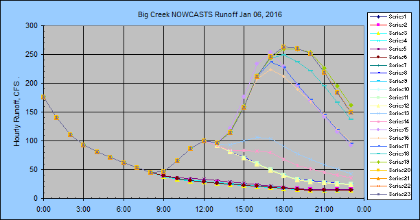
Big Creek Basin, California Sierra foothills:
Note:
There are 2 wind farms with very high reflectivities about 80-90 miles to the
west so the 3rd hour for wind speeds greater than 40 mph with headings 80 to 107
degrees East will not be good. Headings 92-97 should pass between the two
demons.
#1)
Jan 5, 2016
Nowcast period: 3-hour
Adjust type: 1 (n+12)/2 for hour 2 only
Stormtrack: SAC 12000ft winds aloft
Nowcast radar adjust factor: 1.25 (heavy rains tend toward 1.0 at
most radars)
Final series:
G/R adjusted
Precip type: Stratiform rain
Most nowcasts are every half
hour with some 1 hour and at noon there was no rain on the nowcast so the model
set it's schedule to be run next at 15:00... bad idea to use 3 hour schedule
when rain in the area. The stratiform winds aloft were verified manually a
few times using GetNexrad but seemed even better than my eyeball.
National Weather Service SAC 12,000 ft Wind as headings, not froms:
2016-01-05 00:36 :Date 44 MPH NNE 20° winds aloft
2016-01-05 06:36 :Date 20 MPH NE 40° winds aloft
2016-01-05 14:36 :Date 20 MPH ENE 70° winds aloft
2016-01-05 18:49 :Date 21 MPH ENE 70° winds aloft
Basin Lag Time: 3.0 hours
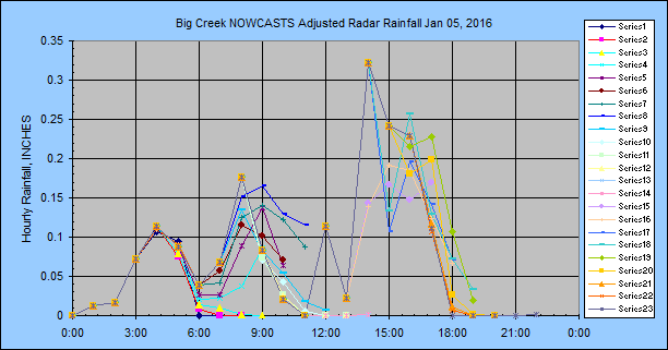
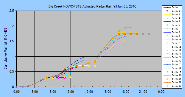
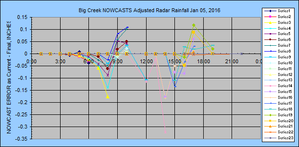
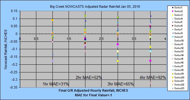
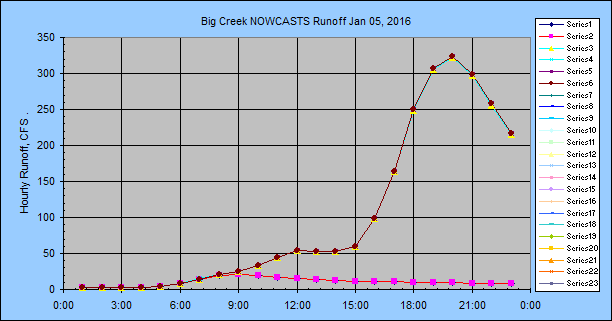
I had set the runoff to be written just every 6 hours so I missed most of it but
the NWS forecast did fine until hour 10:00.
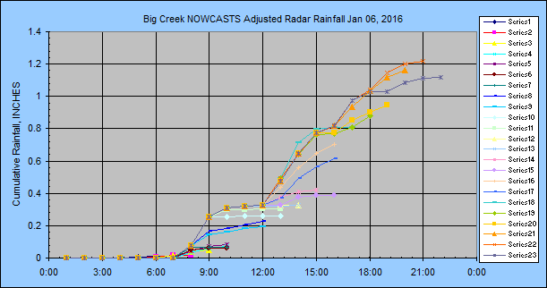
##)
Jan 6, 2016
Nowcast period: 3-hour
Adjust type: 1 (n+12)/2 for hour 2 only
Stormtrack: SAC 12000ft winds aloft
Nowcast radar adjust factor: 1.25 (heavy rains tend toward 1.0 at
most radars)
Final series:
G/R adjusted
Precip type: Stratiform rain
Most nowcasts are every half hour with some 1 hour. The stratiform winds
aloft were verified manually a few times using GetNexrad. Snow occurred
and Wundergages showed about 0.5" of melt the next day and who knows how much
wind induced undercatch due to snow there was so radar adjustments are iffy.
So take with a grain of salt and why final values should be unadjusted raw radar
for the mission here.
National Weather Service SAC 12,000 ft Wind as headings, not froms:
2016-01-06 00:49 :Date 43 MPH NE 40° winds aloft
2016-01-06 06:20 :Date 31 MPH NNE 30° winds aloft
2016-01-06 12:50 :Date 17 MPH NE 40° winds aloft
2016-01-06 18:55 :Date 12 MPH NNE 30° winds aloft
Basin Lag Time: 3.0 hours
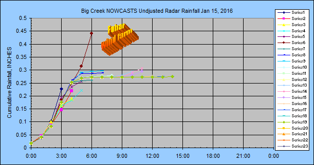
#3)
Jan 15, 2016
Nowcast period: 3-hour
Adjust type: 1 (n+12)/2 for hour 2 only
Stormtrack: OP40 :25 miles west of Buck Meadows
Nowcast radar adjust factor: 1.25 (heavy rains tend toward 1.0 at
most radars)
Final series: raw N0Q radar
Precip type: Stratiform rain
Most nowcasts are
every half hour with some 1 hour. No final hourly radar>0.1" so no MAE.
There are 2 wind farms with very high reflectivities about 80-90 miles to the
west so the 3rd hour for wind speeds greater than 40 mph with headings 80 to 107
degrees East will not be good and explains the high 3:19 hour 3. And to
top it off, this is the typical direction for rain events. Where did the
good ol' days of nuclear go?
National Weather Service
OP40 - 9,800 ft Wind as headings, not froms:
Jan 15, 02:19: 51 MPH East 99° ALT 9967
Jan 15, 03:19: 58 MPH ESE 103° ALT 9917
Jan 15, 04:19: 51 MPH ESE 110° ALT 9983
Jan 15, 05:19: 51 MPH ESE 110° ALT 9983
Jan 15, 08:19: 35 MPH SE 127° ALT 9976
Jan 15, 09:19: 34 MPH SE 132° ALT 9970
Jan 15, 10:19: 36 MPH SE 133° ALT 10032
Basin Lag Time: 3.0 hours
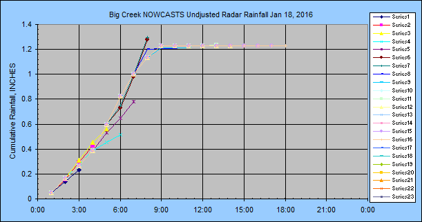
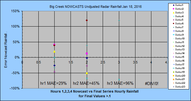
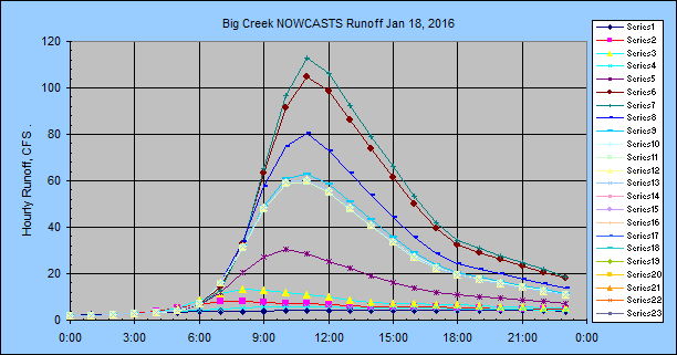
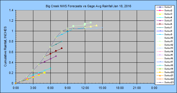
#3)
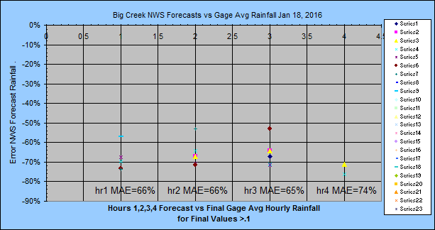
Jan 18, 2016
Nowcast period: 3-hour
Adjust type: none
Stormtrack: OP40 :25 miles west of Buck Meadows
Nowcast radar adjust factor: 1.25 (heavy rains tend toward 1.0 at
most radars)
Final series: raw N0Q radar
Precip type: Stratiform rain
Nowcasts are
every 1 hour. The wind speeds and direction missed the wind farms. I
screwed up the hourly radar flagging until about 10AM where only 2 hours were
being flagged. So I think hours 1 and 2 are really hours 2 and 3... but
I'm not sure so I will leave it alone.
National Weather Service
OP40 - 9,800 ft Wind as headings, not froms:
Jan 17, 23:01: 26 MPH NE 46° ALT 10098'
Jan 18, 00:01: 26 MPH NE 46° ALT 10098'
Jan 18, 01:03: 19 MPH NE 51° ALT 10088'
Jan 18, 02:01: 17 MPH ENE 64° ALT 10125'
Jan 18, 03:01: 14 MPH East 86° ALT 10121'
Jan 18, 04:01: 13 MPH ENE 64° ALT 10098'
Jan 18, 05:01: 13 MPH ENE 64° ALT 10098'
Jan 18, 07:01: 24 MPH ENE 59° ALT 10059'
Jan 18, 08:01: 18 MPH NE 52° ALT 10072'
Jan 18, 09:01: 18 MPH NE 52° ALT 10072'
Jan 18, 10:01: 28 MPH SE 132° ALT 10151'
Jan 18, 11:01: 27 MPH ESE 120° ALT 10138'
Jan 18, 12:01: 29 MPH ESE 114° ALT 10161'
Basin Lag Time: 3.0 hours
NWS Forecasts:
#4)
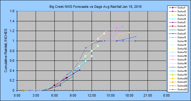
Jan 19, 2016
Nowcast period: 3-hour
Adjust type: none
Stormtrack: OP40 :25 miles west of Buck Meadows
Nowcast radar adjust factor: 1.25 (heavy rains tend toward 1.0 at
most radars)
Final series: raw N0Q radar
Precip type: Stratiform rain
Nowcasts are every 1 hour. The wind speeds
and direction missed the wind farms. After the rain stopped I raised the winds aloft altitude from 10,000 ft
to 12,000 ft because I didn't like the direction and speed. The change put
it back in line with what I was seeing but now it's right back over the wind
farms.
National Weather Service
OP40 - 9,800 ft Wind as headings, not froms:
Jan 19, 04:02: 27 MPH NE 40° ALT 10128'
Jan 19, 05:02: 27 MPH NE 40° ALT 10128'
Jan 19, 06:02: 25 MPH NNE 31° ALT 10092'
Jan 19, 07:02: 35 MPH NNE 29° ALT 10092'
Jan 19, 08:02: 44 MPH NE 50° ALT 10082'
Jan 19, 09:02: 63 MPH NE 45° ALT 10065'
Jan 19, 10:02: 58 MPH NE 47° ALT 10046'
Jan 19, 11:02: 69 MPH ENE 61° ALT 10065'
Reusing Winds Aloft: Jan-19 12:02
Jan 19, 13:02: 56 MPH East 88° ALT 12164'
Jan 19, 14:02: 59 MPH ESE 103° ALT 12144'
Basin Lag Time: 3.0 hours

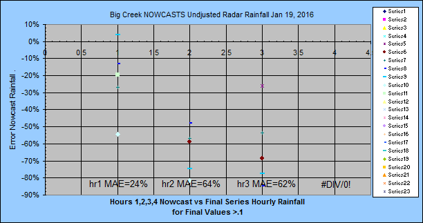
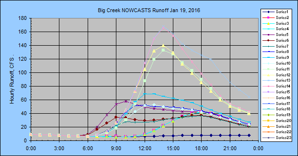
NWS Forecasts:
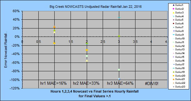
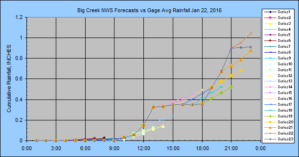
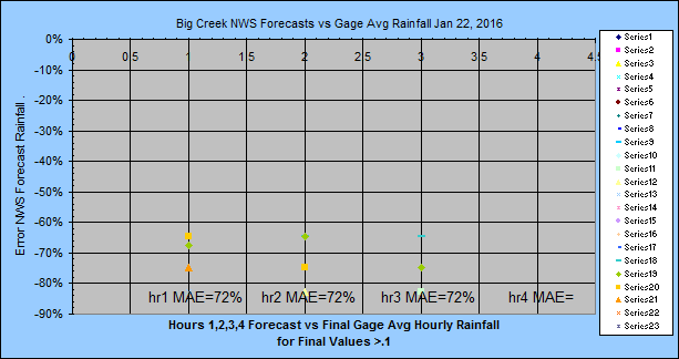
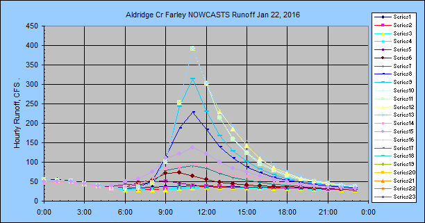
#5)
Jan
22, 2016
Nowcast period: 3-hour
Adjust type: none
Stormtrack: OP40 :25 miles west of Buck Meadows
Nowcast radar adjust factor: 1.25 (heavy rains tend toward 1.0 at
most radars)
Final series: raw N0Q radar
Precip type: Stratiform rain
Nowcasts are every 1 hour. The wind speeds
and direction missed the wind farms.
National Weather Service OP40 -Speed 11,000 ft, Direction 11,000 ft Wind as headings, not froms:
Jan 22, 15:10: 37 MPH NE 34° ALT 12157'
Jan 22, 16:11: 35 MPH NE 41° ALT 12171'
Jan 22, 16:42: 35 MPH ENE 60° ALT 12171'
Jan 22, 17:10: 35 MPH ENE 60° ALT 12171'
Jan 22, 18:10: 36 MPH NE 56° ALT 12180'
Jan 22, 19:10: 39 MPH NE 56° ALT 12184'
Jan 22, 20:10: 37 MPH NE 42° ALT 12161'
Jan 22, 21:10: 35 MPH NNE 32° ALT 12134'
Jan 22, 22:10: 44 MPH NE 44° ALT 12138'
Reusing Winds Aloft: Jan-22 23:10
Jan 23, 00:11: 49 MPH NE 37° ALT 12125'
Basin Lag Time: 3.0 hours
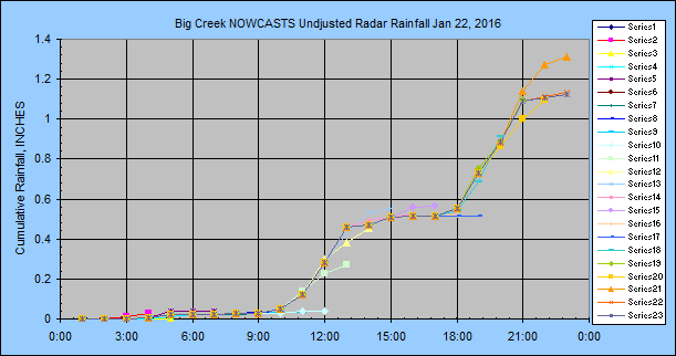

NWS Forecasts:
Birmingham, Alabama:
#1)
Jan 9, 2016
Nowcast period: 3-hour
Adjust type:
0 and 1 (n+12)/2 for hour 2 only
Stormtrack: BHM 18000ft winds aloft
BAD IDEA!!!
Nowcast radar adjust factor: 1.0 (heavy rains tend toward 1.0 at
most radars)
Final series: Unadjusted radar
Precip type:
Thunderstoms small squall lines
Nowcasts are every 1 hour
at hh:46. The winds aloft at 18000ft were 101 MPH.
Not a good thing. I loaded the winds aloft file on a GetNexrad loop and
the 3 rd hour was halfway to New Orleans. This completely missed the
storms traveling about 50 mph and I have since lowered the altitude to 12000ft.
National Weather Service BHM 18,000 ft Wind as headings, not froms:
2016-01-09 00:47 :Date 55 MPH NE 40° winds aloft
2016-01-09 06:46 :Date 86 MPH NE 50° winds aloft
2016-01-09 12:36 :Date 101 MPH ENE
60° winds aloft
altitude lowered from 18000ft to 12000ft
2016-01-09 16:50 :Date 60 MPH NE 50° winds aloft
2016-01-09 18:51 :Date 54 MPH ENE 60° winds aloft
Basin Lag Time: 3.7 hours
The NWS had the right volume
from the start of the day but a few hours early (probably used 100mph winds)
and I had nothing with 100 mph winds.
#2)
Jan
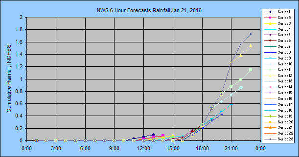
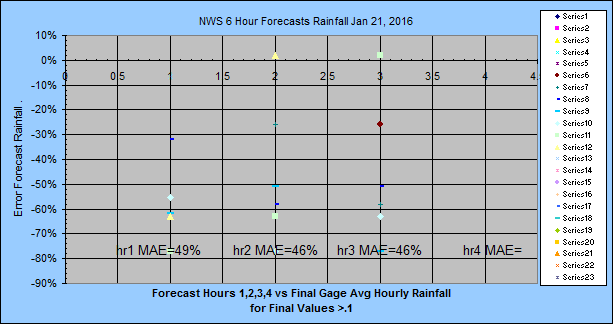
21, 2016
Nowcast period: 3-hour
Adjust type: none
Stormtrack: OP40 :
lat/long of basin
Nowcast radar adjust factor: 1.0 (heavy rains tend toward 1.0 at
most radars)
Final series: raw N0Q radar
Precip type: Cold front.
Nowcasts are every 1 hour.
I was comparing wind speed and direction every hour with my eyeball using
GetNexrad and didn't like what I saw. 17:11 shows typical eyeball speed
and direction. I finally decided to hardwire the direction in GetRealtime
at 18,000 ft and let the user set the speed altitude which I kept at 9800 ft.
This put the direction and speed right on target but a little late in the game
starting 21:08.
National Weather Service
OP40 - 9,800 ft Wind as headings, not froms:
Jan 21, 16:11: 29 MPH NNE 26° ALT 9937'
Jan 21, 17:11: 29 MPH NNE 26° ALT 9937'
Jan 21, 17:32: 55 MPH NE 52° GetNexrad ***Expires 0 hours
so not used***
Jan 21, 18:11: 31 MPH NNE 33° ALT 9947'
Jan 21, 19:11: 39 MPH NNE 25° ALT 9930'
Jan 21, 20:11: 49 MPH NE 37° ALT 9930'
begin direction from 18000 ft, speed at same 9800 ft.
Jan 21, 21:08: 58 MPH NE 45° ALT 9884'
Jan 21, 22:08: 56 MPH NE 46° ALT 9865'
Jan 21, 23:08: 56 MPH NE 46° ALT 9865'
Basin Lag Time: 3.0 hours
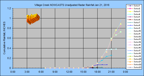
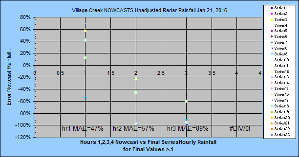
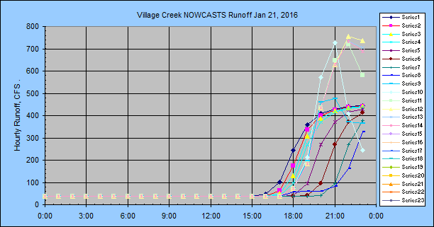
NWS Forecasts:
#3)
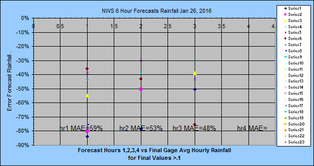
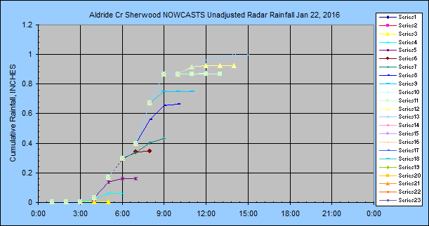
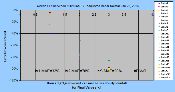
Jan
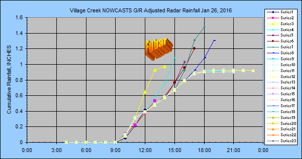
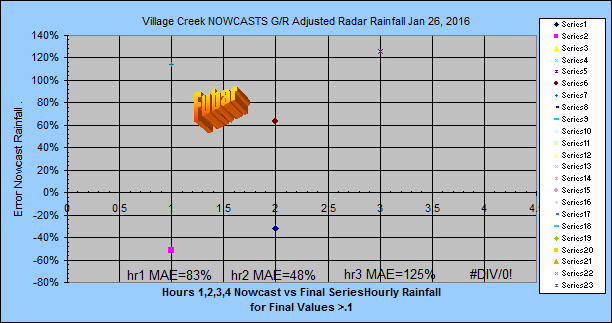
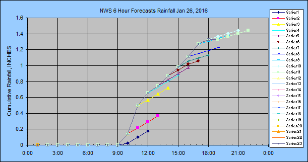
26, 2016 FUBAR FUBAR FUBAR! Although the MAE's were 22%, 31%, 51%.
Nowcast period: 3-hour
Adjust type: none
Stormtrack: OP40 :
lat/long of basin
Nowcast radar adjust factor: 1.0 (heavy rains tend toward 1.0 at
most radars)
Final series: raw N0Q radar
Precip type: Cold front
stratiform rain.
Nowcasts are every 1 hour.
I checked each Nowcast and speed and direction was right on... until the cold
front approached and thats bad news. You have to manually do the nowcast
then. I didn't till to late. The major problem was not the
Nowcast radar, it was that the radar was so far out of wack it needed a 0.5 G/R
adjustment, not the default 1.0.
National Weather Service
OP40 - 9,800 ft Wind as headings, not froms:
Jan 25, 10:33: 38 MPH NE 53° ALT 9907'
Jan 26, 09:02: 39 MPH ENE 61° ALT 9993'
Jan 26, 10:07: 41 MPH ENE 57° ALT 9980'
Jan 26, 11:07: 40 MPH ENE 61° ALT 9970'
Jan 26, 12:07: 40 MPH ENE 61° ALT 9970'
Jan 26, 13:07: 33 MPH ENE 61° ALT 9940'
Jan 26, 14:07: 37 MPH ENE 58° ALT 9927'
Reusing Winds Aloft: Jan-26 15:07
Jan 26, 16:07: 17 MPH NE 43° ALT 9891'
Jan 26, 16:46: 53 MPH ENE 71° GetNexrad and set to expire in 4 hours
Basin
Lag Time: 3.0 hours
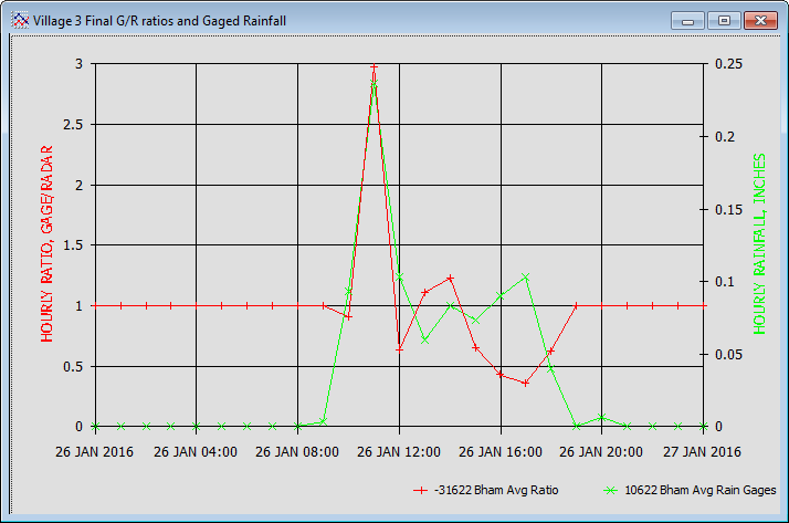
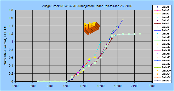
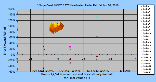
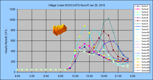
The NWS whipped the snot out of this runoff compared to Nowcasts. FUBAR!!!
But the problem wasn't the Nowcasts as shown by their nice MAE's, it was this
Unadjusted radar compared to final G/R adjusted radar:
NWS Forecasts:
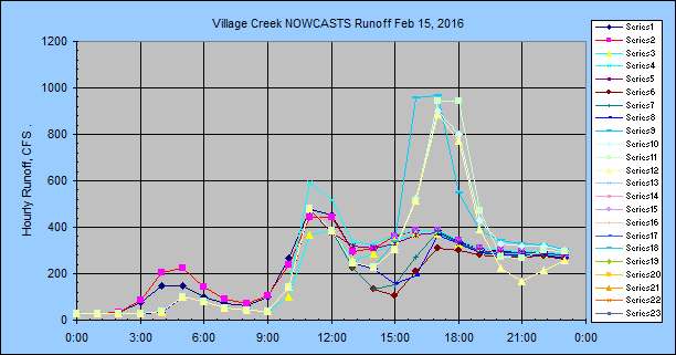
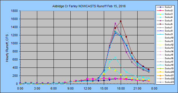
#5)
Feb 15, 2016
Nowcast period: 3-hour
Adjust type: none
The hour 1 adjusted radar nowcast MAE was 89%... but the peak flow looks fine,
just early:
Huntsville, Alabama (you would think same as
Birmingham... NOT!!!!:
#1)
Jan
22, 2016
Nowcast period: 3-hour
Adjust type: none
(and type 1 not shown)
Stormtrack: OP40 :
lat/long of basin
Nowcast radar adjust factor: 1.82
UH OH! Bad Idea??? (heavy rains tend toward 1.0 at
most radars)
Final series: raw N0Q radar
Precip type: Cold front rain
then snow
Nowcasts are every 1 hour. I
only checked the radar at the end of the event and the directions were going
120% apart from one side of the basin to the other. Must have had a low
pressure move right over the basin screwing all of this completely up.... and
SNOW did not help the rain gage readings.
National Weather Service
OP40 - 9,000 ft Wind as headings, not froms:
Jan 22, 00:06: 38 MPH NNE 27° ALT 9782'
Jan 22, 01:06: 44 MPH NNE 18° ALT 9746'
Jan 22, 02:06: 31 MPH NNE 28° ALT 9713'
Jan 22, 03:06: 30 MPH NNE 26° ALT 9680'
Jan 22, 04:05: 33 MPH NNE 27° ALT 9723'
Jan 22, 05:06: 33 MPH NNE 27° ALT 9723'
Jan 22, 06:06: 18 MPH NNE 20° ALT 9638'
Jan 22, 07:06: 18 MPH NNE 20° ALT 9638'
Jan 22, 08:06: 36 MPH North 7° ALT 9598'
Jan 22, 09:06: 37 MPH NNW 339° ALT 9565'
Jan 22, 10:06: 30 MPH NNE 13° ALT 9555'
Basin Lag Time: 3.0 hours
NWS Forecasts:
#3)
Feb 15, 2016
Nowcast period: 3-hour
Adjust type: none
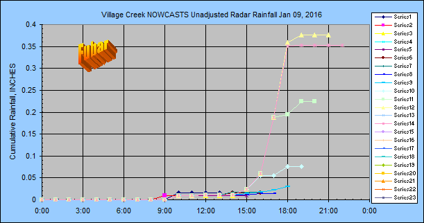
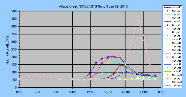
Oneida Creek Subbasin, central New York:
#1)
Jan
10, 2016
Nowcast period: 3-hour
Adjust type: 1 (n+12)/2 for hour 2 only
Stormtrack: SYR 12000ft winds aloft
Nowcast radar adjust factor: 1.14 (heavy rains tend toward 1.0 at
most radars)
Final series: Unadjusted radar
Precip type: I wasn't watching but afterwards I see a squall line to the
southeast
Nowcasts made once an hour at hh:33.
National Weather Service SYR 12,000 ft Wind as headings, not froms:
2016-01-10 00:33 :Date 59 MPH North 350° winds aloft
2016-01-10 06:33 :Date 63 MPH North 10° winds aloft
Basin Lag Time
to Gage: ~12 hours
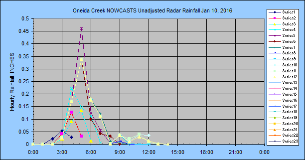
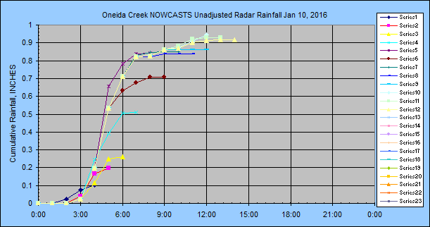
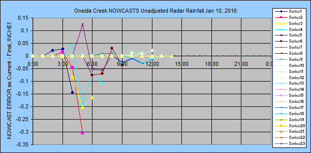
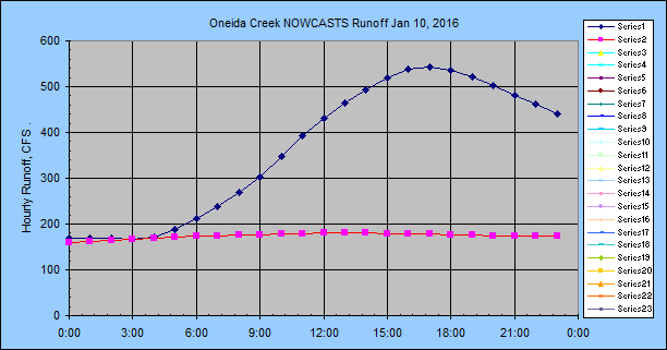
I didn't think conditions warranted running the runoff... dang. The pink
series is using yesterday morning's NWS forecast. In this business you
need the USA radar going 24/7 to keep up with it all.... or have all your basins
running everything 24/7.
Lucky I only dabble in this business... although I do have a Win10 laptop doing
24/7 for California with web updates. I recently put it on a Windows
HomeGroup to copy the database to my REAL Win7 desktop for daily web graphs but
I don't like it. I could map my daily Excel updates to my laptop
database over my HomeGroup but I don't know. Maybe I should see how much
can be done with that foul Win10 laptop without database copying. Cloud
avoidance, although my cable provider is not very reliable when it rains.... or
a new Star Wars movie comes out. Stay tuned... Ah.. it works. I just set
my connectins for GetAccess and GetGraphs and Excel to //laptop and it works
great. So no more copy database. But it aint no cloud and I don't
like the taste of it yet. I'll try it for a while...
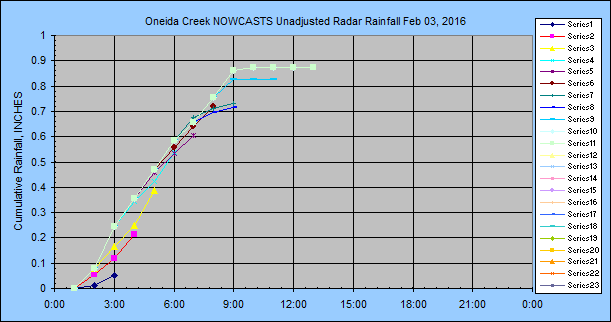
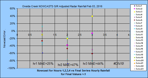
Oneida Creek Subbasin, central New York:
#2)
Feb 3, 2016
Nowcast period: 3-hour
Adjust type: none
Stormtrack: OP40 :
lat/long of basin
Nowcast radar adjust factor: 1.14 (heavy rains tend toward 1.0 at
most radars)
Final series: Unadjusted radar
and G/R Adjusted
Precip type: I wasn't watching.
Nowcasts made once an hour at hh:33.
National Weather Service SYR
7,900 ft speed and direction, Wind as headings, not froms:
Feb 03, 00:17: 55 MPH ENE 58° ALT 8289'
Feb 03, 01:17: 55 MPH ENE 58° ALT 8289'
Feb 03, 02:17: 46 MPH ENE 63° ALT 8312'
Feb 03, 03:17: 40 MPH ENE 58° ALT 8312'
Feb 03, 04:17: 40 MPH ENE 58° ALT 8312'
Feb 03, 05:17: 40 MPH ENE 58° ALT 8312'
Feb 03, 06:17: 64 MPH ENE 62° ALT 8384'
Feb 03, 08:17: 76 MPH ENE 64° ALT 8391'
Feb 03, 09:17: 54 MPH ENE 65° ALT 8411'
Feb 03, 10:14: 55 MPH ENE 72° ALT 8463'
Basin Lag Time
to Gage: ~12 hours
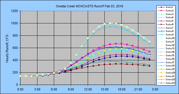
Findings So Far:
1--Ive seen enough alreadty to say Woo Hoo!!! And you don't have to do
anything... but it can and will bite you if your snoozing during the Big One...
the NWS winds aloft aint your mama.
2--Based on hour 2 MAE I'm starting to think my simple Adjust Type 1 is a bad idea.
I'm saving both Adjust Types at Birmingham so we will see eventually.
I have since stopped using Adjust Type 1 and will now try Adjust Type 2 which is
a proration of adjust factor 1 to 0.4 for minutes 60 to 180 if 5-minute rain >
0.05".
3--Beginning Jan 10 after 9:00 AM I changed the nowcast period from at
least 3 hours but possibly 4 to 2.5 to 3.5 hours based on the final radar image
time. The nowcast always ends at the top of the hour so if it's minute hh:30 to hh:00 then 3 to 3.5 hours will actually be
forecast where hh:00 would be 3 hours. If it's hh:05 to hh:25 then 2.5 to 3 hours where hh:05 would be
2 hrs and 55 min. This also means for last images dates hh:00 to hh:25
then 3 hourly values will be flagged 14, else 4 hourly values will be flagged 14
for nowcast for database queries used in the analysis here. So hourly runs
NEAR the top of the hour should provide reasonably consistent populations.
When I move to 30-minute samples I.... 'll cross that bridge then.
4--I've also added 'Mtables OFF' checkbox under the batch so you can make runs
without disturbing the Mtable sequences by injecting ill timed runs. You would only want to do this if
your doing something like what I'm trying to do here with automated Excel
sheets. M-tables are used by GetRealtime to save whatever you want as the model
is writing to the 'real' database R-tables also.
5--The lake effect snows comming off of Lake Erie are a lot closer to the ground
than radar mid-beam scan elevation of 10,000 ft. I set my winds aloft
altitude to 4000 ft for the winter in New York based on manual GetNexrad
tracking. Apparently radar sees everything whether it's looking at it or
not. It will probably bite me when the wind shifts from the south.
6--If your wind direction runs you off your N0Q radar image, then set GetRealtime
to use the Iowa Mesonet's map cutting web service to create real-time radar
images for any location at any size and you probably can get by with half the
1000x1000 pixels of N0Q.
7--The
Birmingham storms have led me to hard wire the wind direction at altitude 18,000
ft and the user will set the speed altitude to suite, probably below 12,000
ft... or optionally both altitudes may be set. GetRealtime.exe has been updated.
8--Cold/Warm Fronts tend to end badly. The winds aloft countinue as they
have but the trailing edge of the front rapidy moves eastward as the storm ends leaving high hour 2
and 3 rains which then turn out to be zero. I have added the option to use
the Maddox 30R70 rule to shift direction and speed if needed.
9--But this was a minor snafu
compared to unadjusted radar vs G/R adjusted which can be running at 0.5, not 1.
I have updated GetRealtime.exe to use the average of the last ratio and the
default ratio for adjusting the nowcast period to help this... but this could be
tricky when the last ratio is 3 and then the next is 0.6 like what happened here
so I'll keep an eye on this.
10--When the winds are blowing 60 to 90 mph to the SE, hour 3 is just looking at
some greenish haze, not real radar. Nowcasts aside, I've been getting
better results at Village Cr with the NCQ of Iowa's composite compared to GWX at
this basin's 100 mile range so this is a simple change for making Nowcasts get a
fair deal. NCQ way over estimate rainfall and generally need at least a
0.5 G/R ratio adjust. If as I think it will turn out, hour 3 nowcasts are a pipe
dream for Thunderstorms so I doubt much help will be found with composite radar,
but we shall see.
11--Nowcasts 3 hours out ALWAYS if big never pan out. I
have updated GetRealtime to take hours 2 and 3 with a grain of salt but will
probably still over shoot.
12--In Arizona
mountains with summer winds at 15 mph, sometimes the storm cells advance
from the oppisite direction at about the same speed. I guess condensation
is advancing thru the water supply at twice the speed of air mass movement.
In this case one could manually set speed and direction using GetNexrad with
expiration in 24 hours.
13.--If the best the NWS QPF can do is 50% low then,
adding 2*P1 to the GetRealtime setup NWS forecast line is beginning to look like
a good idea.
14--Using one of the distribution types on the NWS 6-hour QPF's will
definately improve NWS forecast if you should decide not to use Nowcasts.
I recommend a 2 hour Nowcast with a NWS distribution. The 3rd hour of a
Nowcast will likely be worse than the distributed NWS QPF for hour 3. If
using a Nowcast then you may (see 11 above) want to copy distribution 2, 3, or 4 to a
distribution greater than 4 so that the average NWS QPF is used for the next 6
hours but still distributed beyond 6 hours (see Help).
All seems to work
pretty well out to 3 hours unless you are in the Southern US with prairee fire
squalls and mega thunderstorms the norm rather than exception. The problem
then becomes from what direction to look at the radar. So 1-hour nowcast
is the easy way out here and go with the NWS QPF with a distribution (always use
a distribution). You can manually override winds aloft with GetNexrad for
storm direction if your not asleep. Or like I'm now testing in Alabama,
just a permanate 30R70 adjust for the 3 hours and go back to bed.... Or just use
the NWS 6-hour forecast with a distribution, my adjustments for hours 1, 2 and 3
seem to work pretty darn well... sometimes.
The literature says:
"Lee et al. (2009) found that the Critical Success Index CSI decreased with
increasing rain rate and forecast lead time: the CSI for 60 minute rainfall
forecasts decreased from 0.60 for 0.1 mm/h to 0.2 for 10 mm/h rain rates. Ebert
et al. (2004) reported that the CSI for rain greater than 20 mm/h is essentially
zero. This implies that the use of nowcasting techniques to predict the precise
location of extreme rain for flash flood warning may not be viable." Hence
the 0.8 in/hr table at top to see how true this is.
Hurricane Florence and low pressure centers in
general:
Because of their high speed and curved wind directions using a Radar Nowcast is
not a good option, maybe 1 hour nowcast may work. Looking at the HRRR
future radar forecast vs the NWS 6-hour blocked average foecast it looks like
the NWS forecast is the best way to go for the NEXT 3 HOURS. You can see 2
gages I watched, FloGage#1 and FloGage#2, at the top for listings rain>0.8
in/hr.
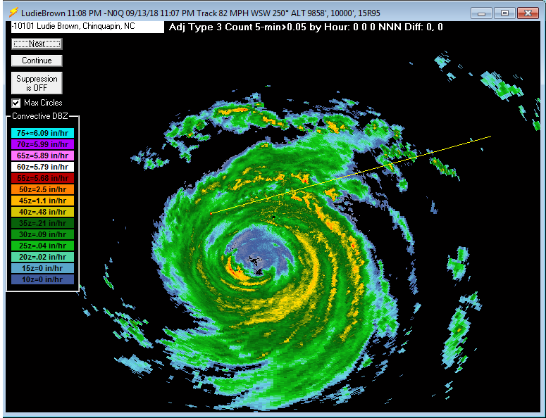
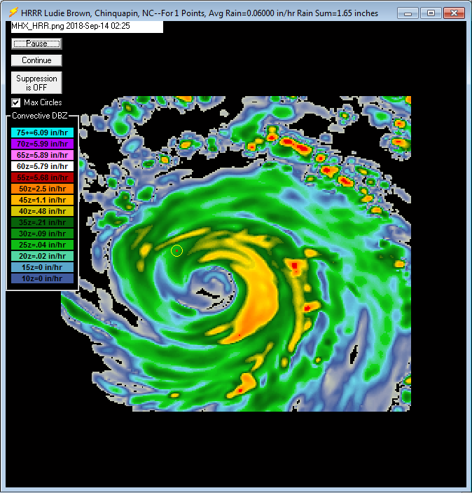
Some additional page links about
ET and Nexrad Radar help and comparisons:
List of How To Videos on Youtube
Help Page for GetNexrad.exe
Nexrad
Rainfall-Runoff Comparison Big Creek, San Jouqin Valley, CA
Nexrad Snowfall Comparisons in western
central Sierras, CA
WEBSITE MAP


WU USGS USBR USCS CWRD NWS
More Free Downloads
Comments/Questions
Email: getmyrealtime@yahoo.com
Label
|