|

source:
Intellicast/Wunderground
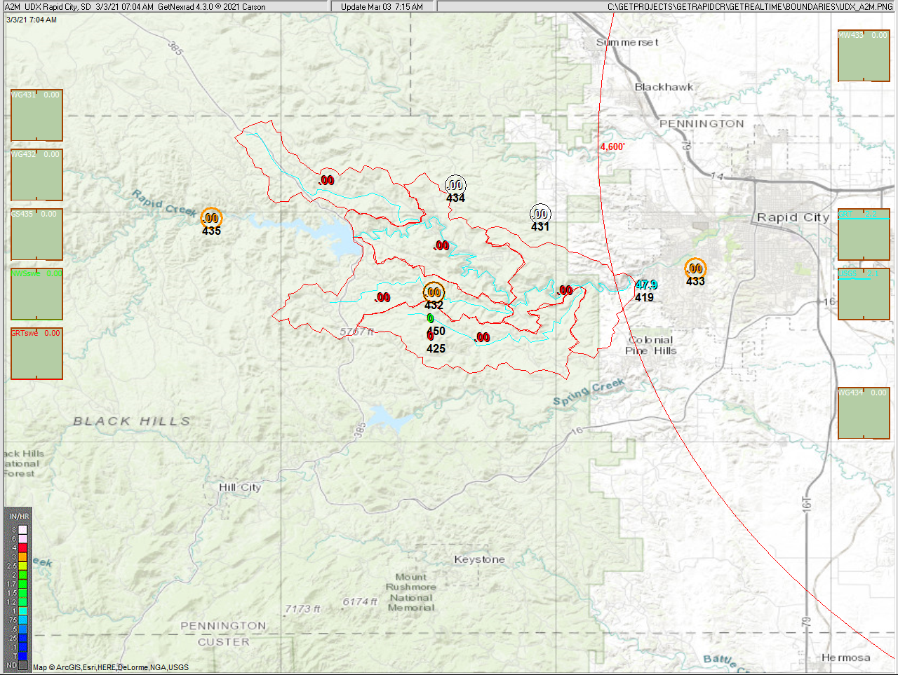
Current radar reflectivity loop above. Below is zoomed N0Q
hi-res Rapid City UDX radar, Wundergages, and
adjusted N0Q at watersheds. Note that the raw N0Q radar here almost always
shows "ground clutter" because of being so close to the radar site. Ground
clutter (0.05" to 0.1" a day) is just another simple matter that rain gage
adjustment removes. No rain at the rain gages for the hour then no radar rain.
Also ground clutter disappears when the radar is in rain mode. (MRMS
adjusted A2M radar product used in winter with frozen rain gages.)
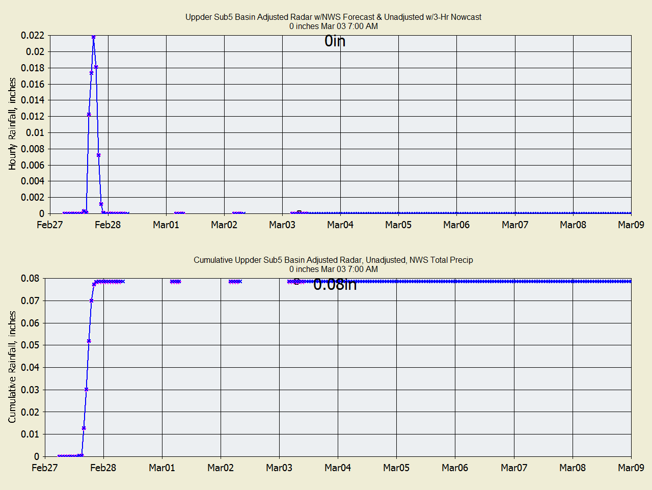
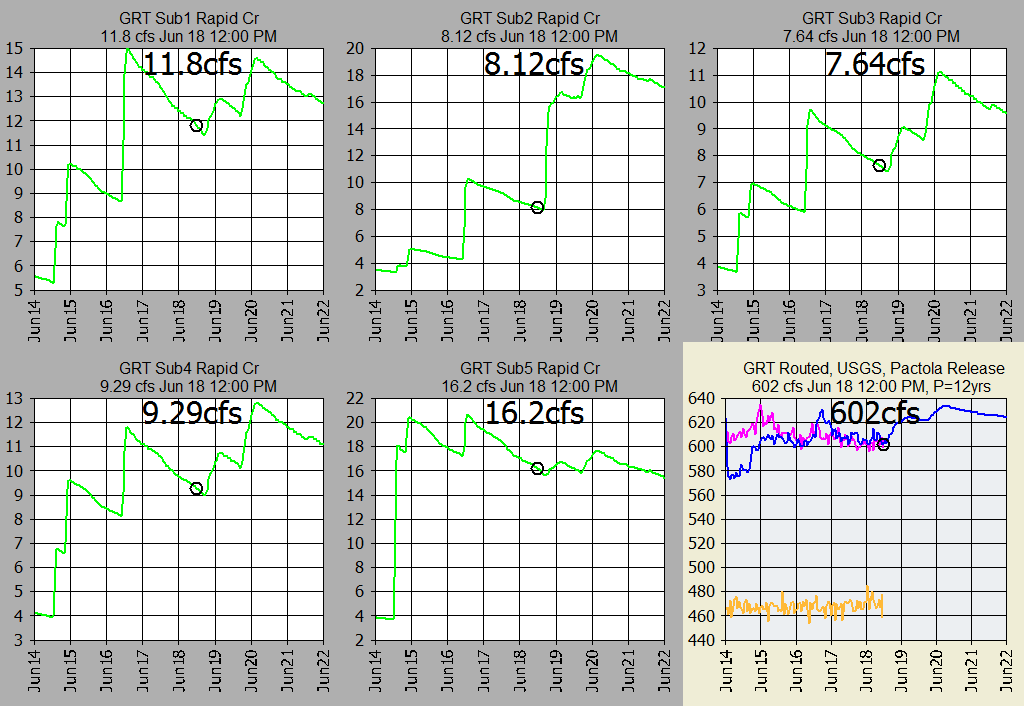
The Rapid Creek basin was subdivided into 5 basins and channel routings were
optimized step Modpul. Forecast scheduled release from Pactola Dam is the
last hourly flow at the USGS gage right below the dam. The June 10, 2019
Pactola Dam release was at a 14 year flood event (encroaching lake levels into
flood control space). GRT uses my continuous
soil moisture adjsted SCS Curve Number method.
GRT model uses the Kansas monthly ET values distribued on an hourly basis over
the year (ET is computed w and w/o gaged Solar for display only here but could
have also been used.
Last model run info from database as text each run
(GetFromAccessNOW.exe):
National Weather Service Flood Stage Forecast:

NWS Model Point VAVS2 Compared to GRT Using NWS Rain+Snow Precip:

Current NWS snowpack:

NOTE ALL TIMES ARE FOR MY PACIFIC TIME ZONE
Current automated graphs and radar (updated often when runoff)
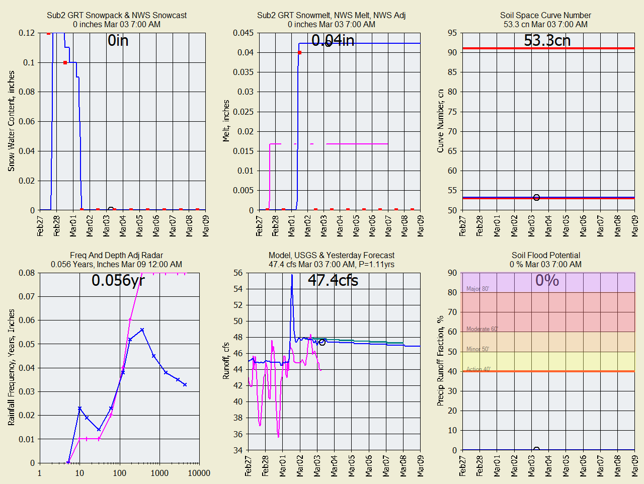
Summary of Snowmelt (Series 1=Blue, Series 2=Pink, Series 3=Orange):
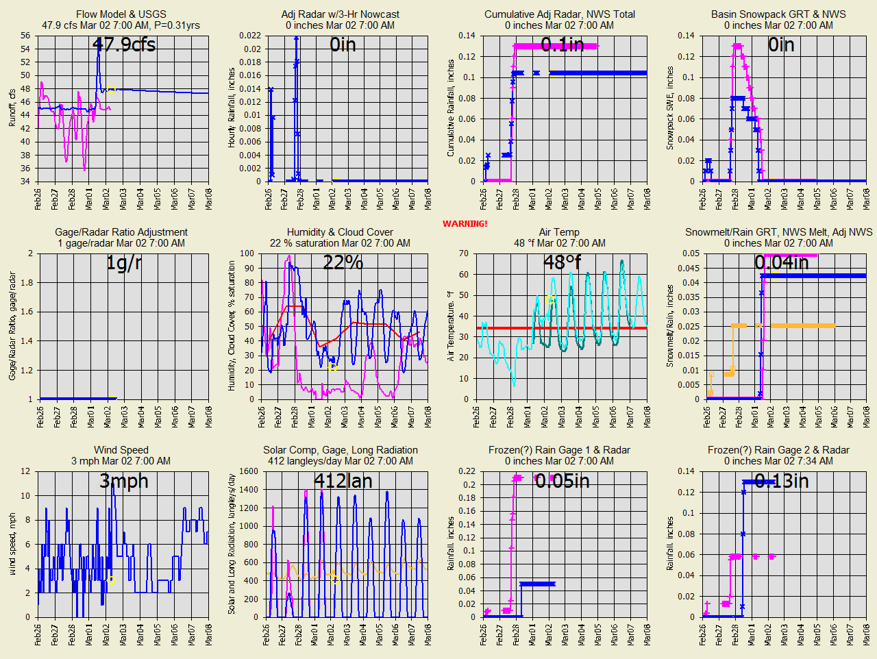
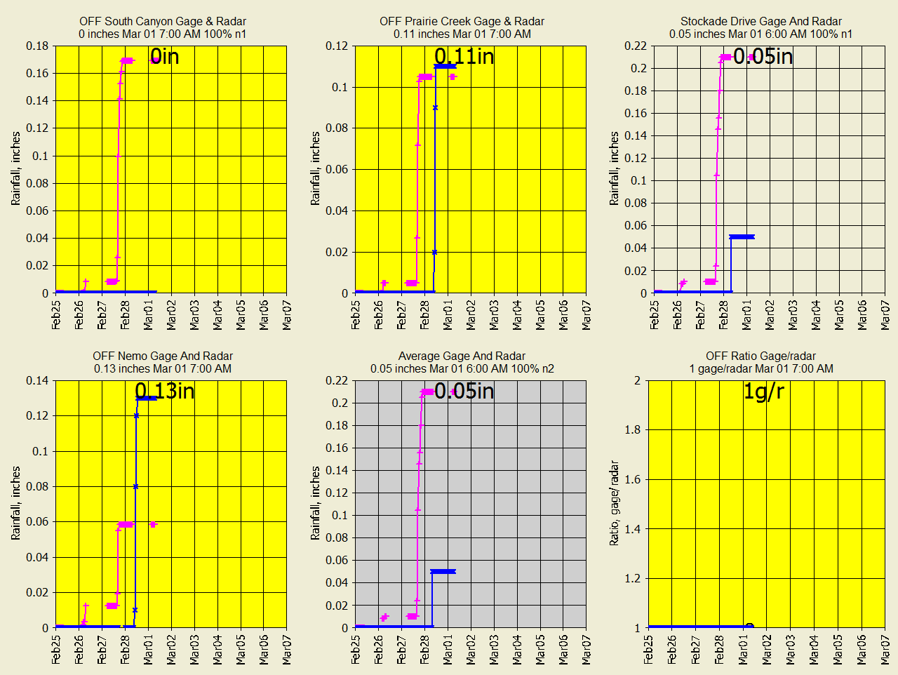
Radar ratio adjusted rainfall and
Wundergages (pink is second parameter referred to) :
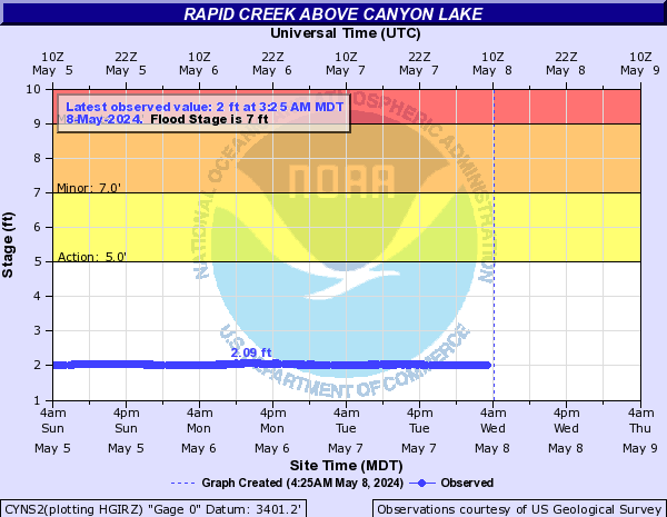
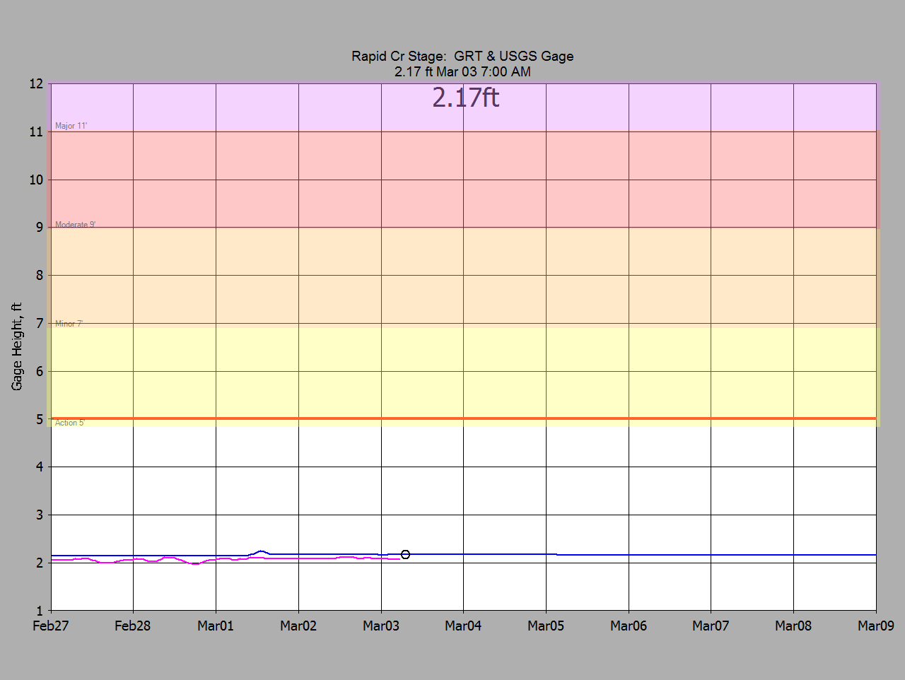
Stage from GRT Forecast
and USGS Gage Rapid Cr above Canyon Lake Dam:
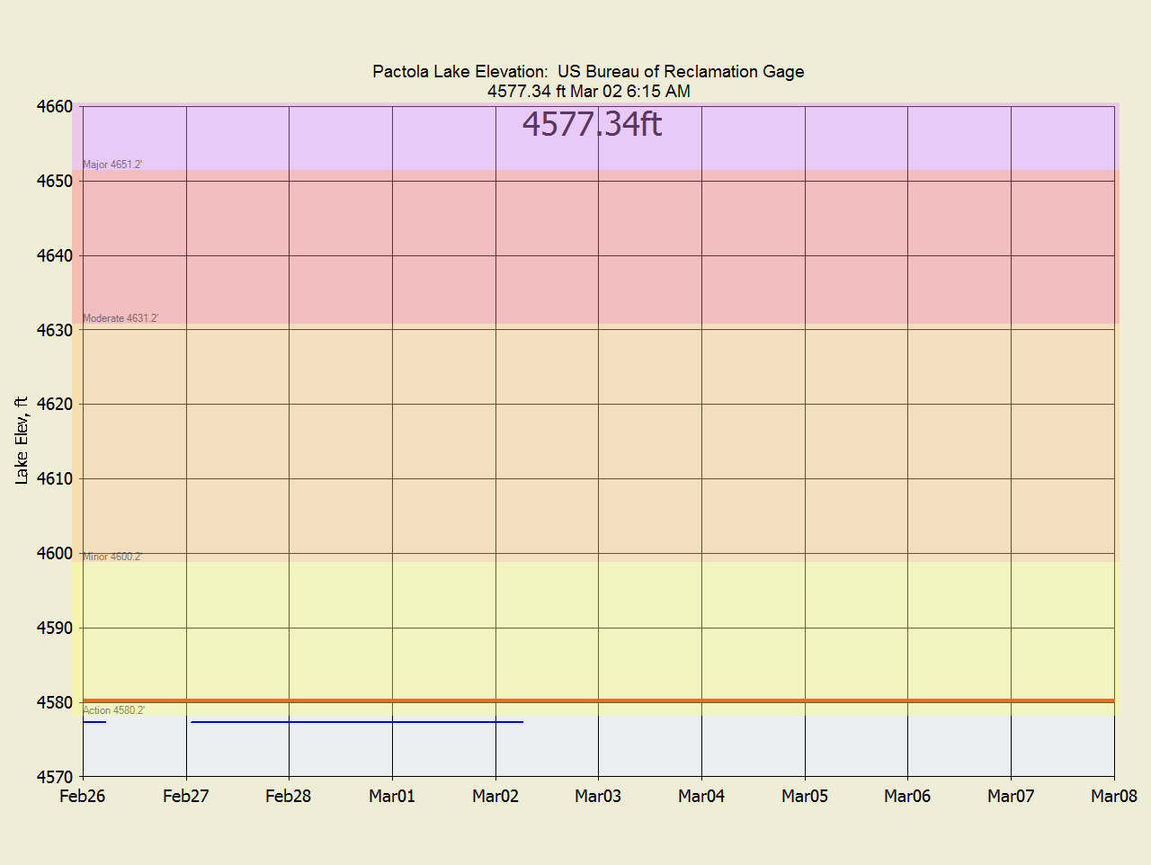
Upstream
Pactola Lake Elevations:
Subbasin runoff (2nd parameter is pink):

Wundergages and radar ratio adjustment (Yellow rain gages turned off, radar MRMS
adjusted A2M is used in winter when all the rain gages are frozen:
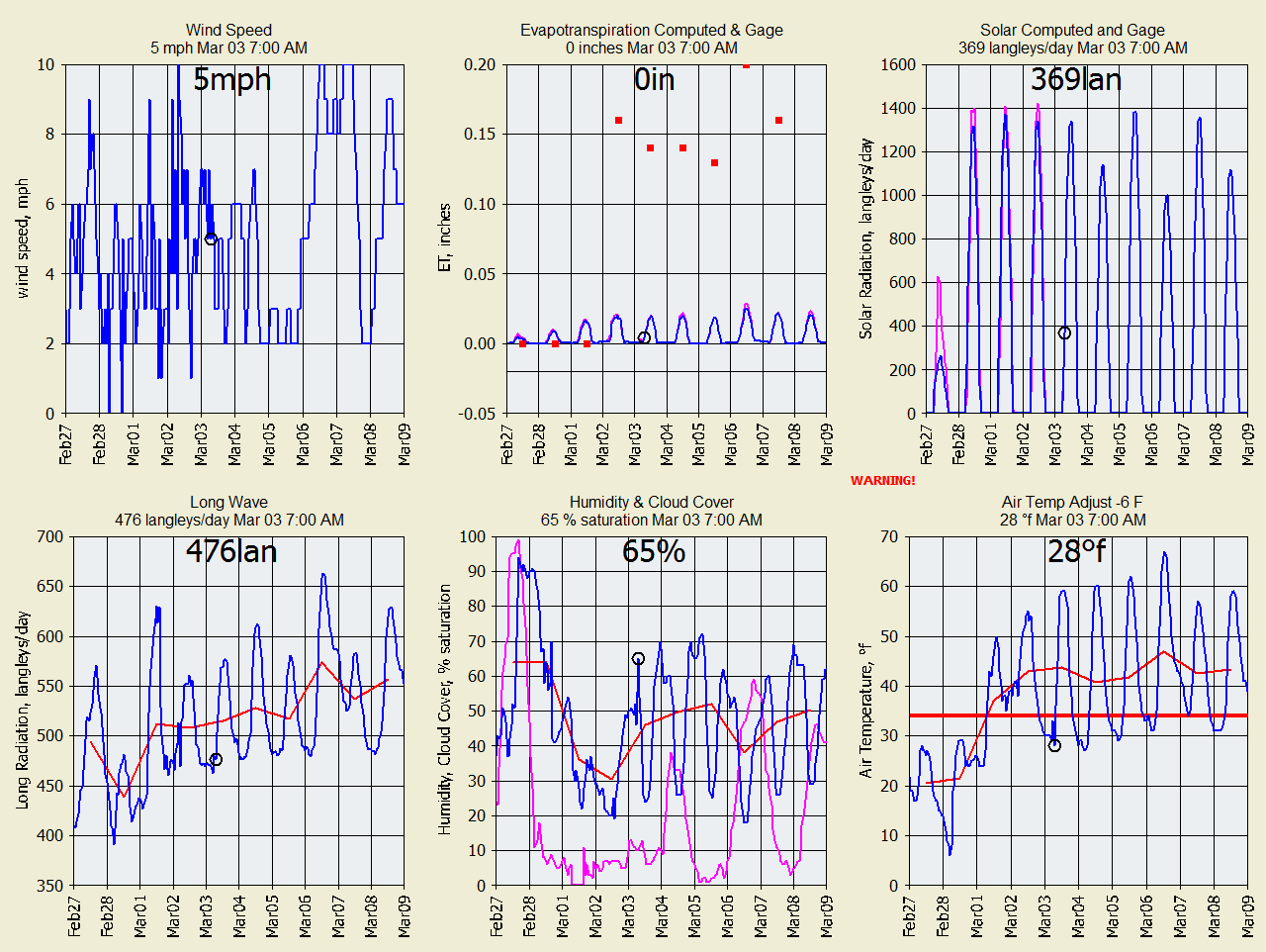
Meteorlogical data from Wundergages for snowmelt and evapotranspiration used by
GRT:
Snowpack and soil moisture info used by GRT:
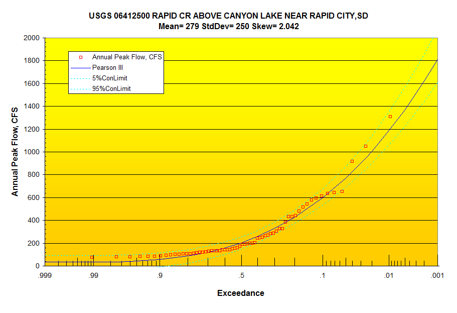
Pearson III Annual Peak Flow Distribution (regulated flow):
NOAA Atlas 14
|
PRECIPITATION FREQUENCY ESTIMATES |
|
|
|
|
|
|
|
by duration for ARI (years): |
1 |
2 |
5 |
10 |
25 |
50 |
100 |
200 |
500 |
1000 |
|
5-min: |
0.293 |
0.364 |
0.49 |
0.605 |
0.778 |
0.924 |
1.08 |
1.25 |
1.49 |
1.68 |
|
10-min: |
0.43 |
0.533 |
0.718 |
0.886 |
1.14 |
1.35 |
1.58 |
1.83 |
2.18 |
2.46 |
|
15-min: |
0.524 |
0.65 |
0.875 |
1.08 |
1.39 |
1.65 |
1.93 |
2.23 |
2.66 |
3.01 |
|
30-min: |
0.712 |
0.883 |
1.19 |
1.47 |
1.9 |
2.25 |
2.63 |
3.05 |
3.64 |
4.12 |
|
60-min: |
0.879 |
1.08 |
1.47 |
1.85 |
2.45 |
2.97 |
3.55 |
4.2 |
5.13 |
5.91 |
|
2-hr: |
1.05 |
1.28 |
1.76 |
2.23 |
3 |
3.7 |
4.47 |
5.34 |
6.63 |
7.7 |
|
3-hr: |
1.15 |
1.39 |
1.9 |
2.43 |
3.33 |
4.16 |
5.09 |
6.16 |
7.76 |
9.1 |
|
6-hr: |
1.42 |
1.64 |
2.16 |
2.75 |
3.78 |
4.75 |
5.89 |
7.19 |
9.17 |
10.8 |
|
12-hr: |
1.76 |
1.99 |
2.51 |
3.11 |
4.14 |
5.12 |
6.26 |
7.57 |
9.55 |
11.2 |
|
24-hr: |
2.11 |
2.39 |
2.99 |
3.63 |
4.72 |
5.73 |
6.88 |
8.2 |
10.2 |
11.8 |
|
2-day: |
2.28 |
2.77 |
3.67 |
4.52 |
5.82 |
6.94 |
8.15 |
9.48 |
11.4 |
12.9 |
|
3-day: |
2.43 |
2.99 |
3.98 |
4.9 |
6.28 |
7.45 |
8.71 |
10.1 |
12 |
13.6 |
Routing file:
Pactola USGS scheduled release and combine with 5 subs
GET 4 -30425 Runoff Sub 5
RELEASE 1415 -1 get USGS release from rhour dsid hourly
ADD +1 remove release value times -1, use +1 to add
ROUTE Modpul RapidCr5_4XsecIn.Rat -1 optimal N cascades
GET 4 -30424 Runoff Sub 4
COMBINE
GET 4 -30423 Runoff Sub 3
COMBINE
ROUTE Modpul RapidCr3_2XsecIn.Rat -1 optimal N cascades
GET 4 -30422 Runoff Sub 2
COMBINE
ROUTE Modpul RapidCr2_1XsecIn.Rat -1 optimal N cascades
GET 4 -30421 Runoff Sub 1
COMBINE
ADD 150 base flow <<I'm working on this as groundwater return fraction (good
luck)
END
Past runoff comparisons for the 5 subs and routed basin runoff:
GetRealtime_setup.txt reads:
Database Connection String=Provider=Microsoft.Jet.OLEDB.4.0;Data
Source=C:\GetProjects\GetRapidCr\GetAccess\GetAccessHDB_RapidCr.mdb;User
Id=admin;Password=;
Station_ID; Datatype_Site_ID; Datatype_Name; Site_Name; base1; shift1; formula1;
base2; shift2; formula2; base3; shift3; formula3
*******; ********; *********; *** FORECASTS ***************** **
FORECAST-NWS; -11420; Rainfall; FORECAST Slate Cr; -2; 44.0878,-103.4479, 3
FORECAST-NWS; -11421; Rainfall; FORECAST Sub1 Rapid Cr; -2; 44.0878,-103.4479, 3
FORECAST-NWS; -11422; Rainfall; FORECAST Sub2 Rapid Cr; -2; 44.0878,-103.4479, 3
Run-FORECAST-NWS; -11423; Rainfall; FORECAST Sub3 Rapid Cr; -2;
44.0878,-103.4479, 3
FORECAST-NWS; -11424; Rainfall; FORECAST Sub4 Rapid Cr; -2; 44.0878,-103.4479, 3
FORECAST-NWS; -11425; Rainfall; FORECAST Sub4 Rapid Cr; -2; 44.0878,-103.4479, 3
Run-FORECAST-NWS; 17433; Temperature; KSDRAPID84; -2; 44.0878,-103.4479
FORECAST-NWS; 18433; Humidity; KSDRAPID84; -2; 44.0878,-103.4479
FORECAST-NWS; 28433; Wind Speed; KSDRAPID84; -2; 44.0878,-103.4479
FORECAST-NWS; 26433; Cloud Cover; KSDRAPID84; -2; 44.0878,-103.4479
************; ************; ************; *****NWS Model Point*******
SNOWCAST-NWS,VAVS2; 11450,23450; Melt, SWE; Victoria Creek
SNOWCAST-NWS,VAVS2; 10450,-10450; Rain,snow; Victoria Creek; 0; 0; P1+P2
SNOWCAST-NWS,VAVS2; 17450,-17450; Air Temp, Surface Temp; Victoria Creek
COMPUTE-Hour; 10453; Rain/melt; NWS Precip Adjust Snowcast Melt; P1=0; 0; P3;
P1>0; 0; P2
*******; ********; *********; *** RADAR ***************** **
NEXRAD-UDX; -10420; Rainfall; Full Rapid Cr, KS; 2; Nowcast 3, adjust type 3
Run-NEXRAD-UDX; -10421; Rainfall; Sub1 Rapid Cr, KS; 2; Nowcast 3, adjust type 3
NEXRAD-UDX; -10422; Rainfall; Sub2 Rapid Cr, KS; 2; Nowcast 3, adjust type 3
NEXRAD-UDX; -10423; Rainfall; Sub3 Rapid Cr, KS; 2; Nowcast 3, adjust type 3
NEXRAD-UDX; -10424; Rainfall; Sub4 Rapid Cr, KS; 2; Nowcast 3, adjust type 3
NEXRAD-UDX; -10425; Rainfall; Sub5 Rapid Cr, KS; 2; Nowcast 3, adjust type 3
NEXRAD-UDX; -10431; Rainfall; Ridgeland Loop, SD; 2
NEXRAD-UDX; -10432; Rainfall; Schmeidler/burke, KS; 2
NEXRAD-UDX; -10433; Rainfall; KSDRAPID84; 2
NEXRAD-UDX; -10434; Rainfall; Peakweather, SD; 2
NEXRAD-UDX; -10435; Rainfall; RAPID CR ABOVE PACTOLA RES AT SILVER CITY, SD; 2
*******; ********; *********; *** HRRR *****************
Run-HRR-UDX; -11422; Forecast Rain; FORECAST Sub2 Rapid Cr; 0; 6
*******; ********; *********; *** Wundergages *****************
KSDRAPID71; 10431; Precip; Ridgeland Loop, SD
KSDRAPID7; 10432; Precip; Prairie Creek, SD
KSDRAPID198; 10434; Precip; Peakweather, SD
06410500; 10435; Precip; RAPID CR ABOVE PACTOLA RES AT SILVER CITY, SD
MW-RWES2; 10433; Precip; Rapid City West Was KSDRAPID84
MW-RWES2; 17433; Temperature; Stockade Drive; -44; 0; P1-6
MW-RWES2; 18433; Humidity; Stockade Drive
MW-RWES2; 28433; Wind Speed; Stockade Drive
MW-RWES2; 29433; Solar Radiation; Stockade Drive; 0; 0; 2.065*P1
*******; ********; *********; *** COMPUTE WEATHER *****************
COMPUTE; 29443; Solar Radiation; C & J Property, KS; 0; 44.0878,-103.4479,-105,
4100
COMPUTE; -29443; Long Radiation; C & J Property, KS; 0
COMPUTE; 27433; Ettall; W/solar C & J Property, KS; 0; 44.0878,-103.4479, -105,
4100, 1; P5
COMPUTE; -27433; ET Alfalfa; C & J Property, KS; 0; 44.0878,-103.4479,-105,
4100,1; P4
*******; ********; *********; *** RATIOS *****************
COMPUTE-Hour; 10430; Rainfall; Buck Meadows Avg of 4 Rain Gages; 0; 0;
(P1+P2+P3+P4)/N
COMPUTE-Hour; -10430; Rainfall; Buck Meadows Avg of 4 Radars; 0; 0;
(P1+P2+P3+P4)/N
Run-COMPUTE-Hour; 31427; Ratio; Buck Meadows, Ca Gage/dax; 0; 9.02, 1, 4; P1/P2
*******; ********; *********; *** ADJ RADAR ***************** **
COMPUTE-5unit; -11420; Rainfall; Slate Cr Basin Adjusted DAX Radar; 0; -1,
1,0.25, 0.80; P1*P2
Run-COMPUTE-5unit; -11421; Rainfall; Sub1 Slate Cr, KS Adjusted DAX Radar; 0;
-1, 1,0.25, 0.80; P1*P2
COMPUTE-5unit; -11422; Rainfall; Sub2 Slate Cr, KS Adjusted DAX Radar; 0; -1,
1,0.25, 0.80; P1*P2
COMPUTE-5unit; -11423; Rainfall; Sub3 Slate Cr, KS Adjusted DAX Radar; 0; -1,
1,0.25, 0.80; P1*P2
COMPUTE-5unit; -11424; Rainfall; Sub4 Slate Cr, KS Adjusted DAX Radar; 0; -1,
1,0.25, 0.80; P1*P2
COMPUTE-5unit; -11425; Rainfall; Sub5 Slate Cr, KS Adjusted DAX Radar; 0; -1,
1,0.25, 0.80; P1*P2
*******; ********; *********; *** Snowmelt ***************** **
SNOWMELT-Unit; 11420,-23420; Melt, SWC; Slate Cr Snowmelt; 0; 0, 1, 1.15, 1, 1,
1, 1, 34
SNOWMELT-Unit; 11421,-23421; Melt, SWC; Sub1 Slate Cr, KS Snowmelt; 0; 0, 1,
1.15, 1, 1, 1, 1, 34
SNOWMELT-Unit; 11422,-23422; Melt, SWC; Sub2 Slate Cr, KS Snowmelt; 0; 0, 1,
1.15, 1, 1, 1, 1, 34
SNOWMELT-Unit; 11423,-23423; Melt, SWC; Sub3 Slate Cr, KS Snowmelt; 0; 0, 1,
1.15, 1, 1, 1, 1, 34
SNOWMELT-Unit; 11424,-23424; Melt, SWC; Sub3 Slate Cr, KS Snowmelt; 0; 0, 1,
1.15, 1, 1, 1, 1, 34
SNOWMELT-Unit; 11425,-23425; Melt, SWC; Sub3 Slate Cr, KS Snowmelt; 0; 0, 1,
1.15, 1, 1, 1, 1, 34
************; ************; ************; *****NWS GRT Adjust******
COMPUTE-Hour; 11451; Rain/melt; Sub2 Precip Adjust NWS Snowcast Melt; P1=0; 0;
P3; P1>0; 0; P2
SNOWMELT-hour; 11453,-23453; Melt, SWC; NWS Model Point NY-MD-22; 0; 0, 1, 1.15,
1, 1, 1, 1, 34
*******; ********; *********; *** Runoff *****************
COMPUTE-5unit; -30421; RUNOFF; Sub1 Slate Cr; 0; 1, 54, 0.10, 3, 10.5, 1.67,
0.09, 0, 2.5, 0, 6.0, 91, 53, 0.4, 0.5, 3, 0.3, 0.8, 0.05, 1, 0, 0.2, 0, 1, 0,
LagV; P1; 0; VillageCreek.DGF
COMPUTE-5unit; -30422; RUNOFF; Sub2 Slate Cr; 0; 1, 54, 0.10, 1, 12.1, 1.67,
0.09, 0, 4, 0, 6.0, 91, 53, 0.4, 0.5, 3, 0.3, 0.8, 0.05, 1.0, 0, 0.2, 0, 1, 0,
LagV; P1; 0; GreatPlains.DGF
COMPUTE-5unit; -30423; RUNOFF; Sub3 Slate Cr; 0; 1, 54, 0.10, 1, 10.8, 1.67,
0.09, 0, 2.5, 0, 6.0, 91, 53, 0.4, 0.5, 3, 0.3, 0.8, 0.05, 1.0, 0, 0.2, 0, 1, 0,
LagV; P1; 0; GreatPlains.DGF
COMPUTE-5unit; -30424; RUNOFF; Sub4 Slate Cr; 0; 1.5, 54, 0.10, 1, 11.6, 1.67,
0.09, 0, 2.5, 0, 6.0, 91, 53, 0.4, 0.5, 3, 0.3, 0.8, 0.05, 1.0, 0, 0.2, 0, 1, 0,
LagV; P1; 0; GreatPlains.DGF
COMPUTE-5unit; -30425; RUNOFF; Sub5 Slate Cr; 1; 1.5, 54, 0.10, 0, 8.88, 1.67,
0.09, 0, 2.5, 0, 6.0, 91, 53, 0.4, 0.5, 3, 0.3, 0.8, 0.05, 1.0, 0, 0.2, 0, 1,
-1, LagV; P1; 0; GreatPlains.DGF
06411500; 1415; Flow; Rapid Cr below Pactola Dam, SD
Run-Route; -1419; ROUTED FLOWS; Subs 1-5 + Pactola Release
Lookup; -2419; Stage; Slate Creek at Wellington, KS
COMPUTE-hour; -6425; Future Runoff Fraction; Basin Future Fraction Runoff; 0; 0;
0; P2>0.2*P1; 0; 100*(P2-0.2*P1)^2/(P2+0.8*P1)/P2
COMPUTE-hour; -5425; SCS CN; Full Slate Cr Basin; 0; 0; 1000/(P1+10)
USBRGP-ptr; 3414; Elevation; Pactola Dam, SD 06412500; 1419; Flow; RAPID CR
ABOVE CANYON LAKE
06412500; 2419; Stage; RAPID CR ABOVE CANYON LAKE
*******; ********; *********; *** SHELL *****************
SHELL-C:\GetProjects\GetRapidCr\GetGraphs\GetFromAccessNOW.exe rdaymax, 10430
-10430 -11425 -23425 -1419 1419, -2, 5, RapidCreekNOW.txt, mypassword; 0; Flow
Data to Web; Put Flow Data Text File on Web; 0
****SET-INTERVAL; -11420; Rainfall; Big Creek Adj & Forecast; +3,rhour; 60;
P1>.001; 0; 30; P1>.02 **IF; -1419; Flow Check; Adj & Forecast Runoff; rdaymax;
SKIP-2; P1<20
SHELL-C:\GetProjects\GetRapidCr\GetNexrad\GetNexrad.exe -2 mypassword; 0;
Picture; Rapid Creek Nexrad Picture; 0
SHELL-C:\GetProjects\GetRapidCr\GetGraphs\GetGraphs.exe 4 mypassword; 0; Graphs;
Getgraphs to Web; 0 END
Important Note: Nothing on this page is intended as
interpretation of any legal authority such as water rights and supply. This page
is intended solely as a demonstration of techniques in flood potential
monitoring. The reader assumes all risk for any damages whatsoever in connection
with the access, use, quality, or performance of the supplied data just so you
know.
|